
Mülligen facts for kids
Quick facts for kids
Mülligen
|
||
|---|---|---|
 |
||
|
||

Mülligen
Location in Switzerland

Mülligen
Location in Canton of Aargau
|
||
| Country | Switzerland | |
| Canton | Aargau | |
| District | Brugg | |
| Area | ||
| • Total | 3.16 km2 (1.22 sq mi) | |
| Elevation | 363 m (1,191 ft) | |
| Population
(Dec 2020 )
|
||
| • Total | 1,074 | |
| • Density | 339.9/km2 (880.3/sq mi) | |
| Postal code |
5243
|
|
| Surrounded by | Birmenstorf, Birr, Hausen, Lupfig, Windisch | |


Mülligen is a small town, also called a municipality, in Switzerland. It's located in the Aargau canton, which is like a state, and is part of the Brugg district.
Contents
History of Mülligen
Mülligen has a long history. The first known settlement here was during the Early Middle Ages. We know this because two groups of old graves were found.
The town was first mentioned in old writings in the 12th century. Back then, it was called Mülinon. It was known as Mülinen until the 17th century.
For a long time, Mülligen was controlled by the Habsburg family. Later, the city of Bern took over these rights.
How Mülligen Grew
At first, most people in Mülligen worked in farming and making wine. After 1730, some people started making textiles at home to earn more money.
In 1849, a factory opened that processed Gypsum, a mineral used in building. Around 1830, many people from Mülligen also started working in a big spinning mill in Windisch.
The first industrial factory in Mülligen itself opened in 1909. A gravel plant started in 1924 and got bigger in 1955. In 1964, a special center for animal breeding opened.
A bridge was built in 1940 to replace a ferry across the Reuss river. Today, Mülligen is a popular place to live. Many people who live here travel to nearby cities like Brugg, Baden, and Zurich for work. This is because it's close to major highways.
Geography of Mülligen
Mülligen covers an area of about 3.16 square kilometers (1.22 square miles). A big part of this land is used for farming, about 36.7%. Forests cover another 32.0% of the area.
About 28.2% of the land has buildings or roads. A small part, 2.5%, is rivers or lakes. The rest, 0.3%, is land that cannot be used for anything.
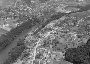
The town is located in the Brugg district. It sits near the Reuss river and on the southern side of a hill called the Eiteberg. Mülligen includes the main village and a small hamlet called Trotte.
Mülligen's Coat of Arms
The coat of arms for Mülligen shows a black mill wheel on a gold background. Below the wheel are three green hills.
This design is an example of a "canting arm." This means the picture on the coat of arms gives a hint about the town's name. In German, "Mühlrad" means "mill wheel," which sounds like "Mülligen."
Population and People
Mülligen has a population of about 1,000 people. As of June 2009, about 12.7% of the people living here were from other countries. Over ten years, the population grew by about 17.3%.
Most people in Mülligen speak German (94.9%). A smaller number speak French (1.3%) or Italian (1.0%).
Age Groups and Homes
In Mülligen, about 9.8% of the population are children aged 0 to 9 years old. Teenagers aged 10 to 19 make up about 13.0% of the population.
Many homes in Mülligen are owned by the people who live in them. In 2000, there were many homes with 3 or 4 people, and also many with 5 or more people. On average, there were about 2.57 people living in each home.
In 2008, about 38.7% of all homes were single-family houses. There were very few empty apartments, showing that Mülligen is a popular place to live.
Education in Mülligen
Most adults in Mülligen (aged 25 to 64) have finished high school or gone on to higher education. This could be a university or a specialized college.
In the 2008/2009 school year, there were 55 students attending primary school in Mülligen.
Historical Population Numbers
Here's how Mülligen's population has changed over time:
| Historical population | ||
|---|---|---|
| Year | Pop. | ±% |
| 1764 | 151 | — |
| 1803 | 320 | +111.9% |
| 1850 | 397 | +24.1% |
| 1900 | 374 | −5.8% |
| 1950 | 377 | +0.8% |
| 2000 | 780 | +106.9% |
Economy of Mülligen
In 2007, Mülligen had a low unemployment rate of 1.44%. This means most people who wanted to work had jobs.
What People Do for Work
The economy of Mülligen is divided into three main parts:
- Primary sector: This includes jobs like farming. About 36 people worked in this area in 2005.
- Secondary sector: This includes manufacturing and factories. About 34 people worked in this area.
- Tertiary sector: This includes services, like shops, offices, and healthcare. About 44 people worked in this area.
Many people who live in Mülligen travel to other towns for work. In 2000, about 83.3% of residents worked outside Mülligen. However, 106 people came into Mülligen for work.
Most people (59.7%) use a private car to get to work. About 13.6% use public transportation.
Religion in Mülligen
Based on a census from 2000, about 34.7% of the people in Mülligen were Roman Catholic. About 52.7% belonged to the Swiss Reformed Church.
Weather in Mülligen
Mülligen usually has about 133.5 days of rain or snow each year. The total amount of rain or snow is about 1036 millimeters (40.8 inches) per year.
The wettest month is August, with about 113 millimeters (4.4 inches) of rain or snow. It rains or snows for about 11.7 days in August. May has the most days of precipitation, with an average of 13 days, but less rain overall. The driest month is October, with about 70 millimeters (2.8 inches) of precipitation.
See also
 In Spanish: Mülligen para niños
