M4 motorway facts for kids
Quick facts for kids
M4 motorway |
||||
---|---|---|---|---|
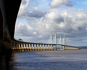
Prince of Wales Bridge looking towards Wales
|
||||
Route information | ||||
Part of | ||||
Maintained by Highways England South Wales Trunk Road Agent |
||||
Length | 189 mi (304 km) | |||
Existed | 1963–present | |||
History | Opened: 1959 (Chiswick Flyover), 1961 (as A4(M)), 1963, 1966 (as A48(M)) Completed: 1996 |
|||
Major junctions | ||||
East end | Chiswick 51°29′23″N 0°16′41″W / 51.4897°N 0.2781°W |
|||
J4b → M25 motorway / J8/9 → A308(M) motorway/A404(M) motorway J10 → A329(M) motorway J19 → M32 motorway J20 → M5 motorway J21 → M48 motorway J22 → M49 motorway J23 → M48 motorway J29 → A48(M) motorway |
||||
To | Pont Abraham 51°44′42″N 4°03′54″W / 51.7451°N 4.0651°W |
|||
Location | ||||
Counties: | Greater London, Berkshire, Wiltshire, Gloucestershire, Monmouthshire, Newport, Cardiff, Vale of Glamorgan, Rhondda Cynon Taf, Bridgend, Neath Port Talbot, Swansea, Carmarthenshire | |||
Primary destinations: |
London London Heathrow Airport Slough Maidenhead Reading Newbury Swindon Bristol Newport Cardiff Bridgend Port Talbot Neath Swansea |
|||
Road network | ||||
|
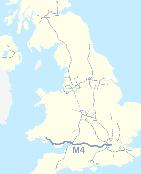
The M4 is a long motorway in the United Kingdom. It goes from London to South Wales. It also passes Bristol. It was first called the London–South Wales Motorway.
Contents
Junctions
M4 motorway | ||||
mile | km | Eastbound exits (B carriageway) | Junction | Westbound exits (A carriageway) |
---|---|---|---|---|
7.3 | 11.8 | Road continues as A4 to Central London | J1 |
Start of motorway |
8.3 8.5 |
13.4 13.7 |
North Circular A406 South Circular A205 Chiswick A315 |
J2 | Staines, Hounslow, Brentford A4 |
12.5 12.8 |
20.1 20.6 |
Heston services | Services | Heston services |
13.4 13.7 |
21.5 22.1 |
Heathrow (Terminals 4, 5 & Cargo), Hayes, Harrow, Hounslow A312 | J3 | Heathrow (Terminals 4, 5 & Cargo), Hayes, Harrow, Hounslow A312 |
15.2 15.7 |
24.5 25.2 |
Heathrow (Terminals 2 & 3) (A4) Uxbridge A408 |
J4a | Heathrow (Terminals 2 & 3) (A4) Uxbridge A408 |
16.8 17.7 |
27.0 28.5 |
Heathrow (Terminals 4, 5 & Cargo) , Gatwick Airport , Watford (M3), (M23), (M40), (M1) M25 | J4b |
Heathrow (Terminals 4, 5&Cargo), Gatwick, Watford (M3), (M23), (M40), (M1), M25 |
19.1 19.5 |
30.7 31.4 |
Colnbrook, Langley, Slough (East) A4 Eton, Datchet B470 |
J5 | Colnbrook, Langley, Slough (East) A4, Datchet B470 |
22.9 23.2 |
36.8 37.4 |
Slough (Central) A355 Windsor A322 |
J6 | Slough (Central) A355 Windsor A322 |
24.7 25.0 |
39.8 40.3 |
Slough (West) A4 | J7 | Slough (West) A4 |
27.8 28.2 |
44.7 45.4 |
High Wycombe, Henley A404(M) Maidenhead A308(M) |
J8/9 | High Wycombe, Henley A404(M) Maidenhead A308(M) |
35.0 35.8 |
56.4 57.6 |
Reading (East), Wokingham, Bracknell A329(M) | J10 | Reading (East), Wokingham, Bracknell A329(M) |
40.6 41.2 |
65.4 66.3 |
Basingstoke, Reading (Central & South) A33 | J11 | Basingstoke, Reading (Central & South) A33 |
43.5 43.8 |
70.0 70.5 |
Reading services | Services | Reading services |
45.3 45.7 |
72.9 73.5 |
Reading (West), Theale A4 | J12 | Reading (West), Theale A4 |
56.9 57.2 |
91.5 92.1 |
Newbury, Oxford A34 Chieveley services (Moto) |
J13 Services |
Newbury, Oxford A34 Chieveley services (Moto) |
64.4 64.8 |
103.7 104.3 |
Hungerford, Wantage A338 | J14 | Hungerford, Wantage A338 |
68.7 | 110.5 | Membury services | Services | Membury services |
76.4 77.1 |
122.9 124.0 |
Swindon (East) A419 Marlborough A346 Oxford (A420) |
J15 | Swindon A419, Marlborough A346 |
82.4 82.8 |
132.6 133.2 |
Swindon (West), Royal Wootton Bassett, Wroughton, MoD Lyneham, Calne A3102 | J16 | Swindon (West), Royal Wootton Bassett, Wroughton, MoD Lyneham, Calne A3102 |
94.8 95.3 |
152.5 153.4 |
Chippenham A350 Cirencester A429 |
J17 | Chippenham A350 Cirencester A429 |
96.7 | 155.7 | Leigh Delamere services | Services | Leigh Delamere services |
104.9 105.6 |
168.8 170.0 |
Bath, Stroud A46 | J18 | Bath, Stroud A46 |
112.8 113.2 |
181.5 182.1 |
Bristol M32 | J19 | Bristol M32 |
115.8 116.3 |
186.3 187.2 |
The SOUTH WEST, Bristol (West), The MIDLANDS, Gloucester, Bristol Airport , M5 | J20 Almondsbury Interchange |
The SOUTH WEST, Bristol (West) M5(S) The MIDLANDS, Gloucester M5(N) |
117.7 189.5 |
189.5 190.0 |
No access | J21 | Chepstow M48 |
121.3 121.6 |
195.2 195.7 |
Avonmouth M49 | J22 | Avonmouth M49 |
121.7 124.1 |
195.9 199.8 |
Entry into England | Second Severn Crossing |
Entry into Wales |
127.0 | 204.4 | No toll plaza | Bridge Toll | Former Toll plaza (closed Dec 2018) |
129.2 | 208.0 | Chepstow M48 | J23 | No access |
131.4 132.2 |
211.4 212.8 |
Magor, Caldicot A4810 Magor services |
J23A Services |
Magor, Caldicot A4810 Magor services |
134.8 135.6 |
217.0 218.3 |
City centre A48 Newport (East) B4237 Monmouth A449 The MIDLANDS (M50) |
J24 | City centre A48 Newport (East) B4237 Monmouth A449 |
137.9 | 222.0 | No access | J25 | Caerleon B4596 |
138.3 | 222.6 | No access | J25A | Newport, Cwmbran A4042 |
138.8 139.1 |
223.4 223.8 |
Brynglas Tunnels | Tunnel | Brynglas Tunnels |
139.1 139.5 |
223.8 224.5 |
Newport, Cwmbran, Caerleon A4051 | J26 | Newport A4051 |
140.8 141,4 |
226.6 227.6 |
High Cross B4591 | J27 | High Cross B4591 |
142.0 142.9 |
228.5 230.0 |
Newport A48 Risca, Brynmawr A467 |
J28 | Newport A48 Risca, Brynmawr A467 |
143.6 | 231.1 | No access | J29 | Cardiff (East and South) A48(M) |
146.6 147.3 |
236.0 237.0 |
Cardiff (East) A4232 Cardiff Gate services |
J30 Services |
Cardiff (East) A4232 Cardiff Gate services |
151.9 244.5 |
244.5 246.1 |
Merthyr Tydfil, Cardiff A470 | J32 | Cardiff (North), Merthyr Tydfil A470 |
155.4 156.0 |
250.1 251.1 |
Cardiff (West), Barry, Penarth A4232 Cardiff Airport Cardiff West services |
J33 Services |
Cardiff (West), Barry, Penarth A4232 Cardiff Airport Cardiff West services |
157.5 158.1 |
253.5 254.4 |
Llantrisant, Rhondda A4119 Royal Glamorgan Hospital |
J34 | Llantrisant, Rhondda A4119 Royal Glamorgan Hospital |
163.9 164.4 |
263.7 264.5 |
Pen-coed A473 | J35 | Bridgend, Pen-coed A473 |
167.5 168.3 |
269.6 270.8 |
Bridgend A4061 Maesteg A4063 Princess of Wales Hospital Sarn Park services |
J36 Services |
Bridgend A4061 Maesteg A4063 Princess of Wales Hospital Sarn Park services |
172.8 173.5 |
278.1 279.3 |
Pyle, Porthcawl A4229 | J37 | Porthcawl, Pyle A4229 |
177.0 177.3 |
284.9 285.3 |
Port Talbot A48 | J38 | Port Talbot A48 |
178.3 | 286.9 | No access (on-ramp only) | J39 | No access |
179.7 179.9 |
289.2 289.6 |
Port Talbot A4107 | J40 | Port Talbot A4107 |
180.9 181.3 |
291.1 291.8 |
Port Talbot A48 | J41 | Briton Ferry A48 |
183.9 184.9 |
295.9 297.3 |
Briton Ferry A48 Swansea (South) A483 |
J42 | Swansea (South) A483 |
184.9 185.7 |
297.5 298.8 |
Neath, Merthyr Tydfil A465 | J43 | Neath, Merthyr Tydfil A465 |
187.0 187.4 |
300.9 301.6 |
Swansea (East) A48 | J44 | Swansea (East) A48 |
188.8 189.3 |
303.9 304.7 |
Pontardawe, Swansea (North) A4067 | J45 | Pontardawe, Swansea (North) A4067 |
190.8 191.4 |
307.0 308.0 |
Llangyfelach B4489 Felindre Morriston Hospital |
J46 | Llangyfelach B4489 Felindre Morriston Hospital |
192.4 193.1 |
309.6 310.7 |
Swansea (West) A483 Gorseinon A48 Swansea services |
J47 Services |
Swansea (West) A483 Gorseinon A48 Swansea services |
196.4 197.1 |
316.0 317.2 |
Pontarddulais, Llanelli A4138 | J48 | Pontarddulais, Llanelli A4138 |
199.2 | 320.6 | Start of motorway | J49 Terminus Services |
Motorway terminates at a roundabout: Carmarthen A48 Ammanford, Llandeilo A483 Pontarddulais A48 Pont Abraham services |
1.000 mi = 1.609 km; 1.000 km = 0.621 mi |
Coordinates
Images for kids
-
M4 bridge over the River Neath (left) original A48(M) bridge (right)
-
Brynglas Tunnels – western portals
See also
In Spanish: Autopista M4 para niños
All content from Kiddle encyclopedia articles (including the article images and facts) can be freely used under Attribution-ShareAlike license, unless stated otherwise. Cite this article:
M4 motorway Facts for Kids. Kiddle Encyclopedia.