
Macquarie Place Park facts for kids
Quick facts for kids Macquarie Place Park |
|
|---|---|

Macquarie Place in the 1920s.
|
|
| Lua error in Module:Location_map at line 420: attempt to index field 'wikibase' (a nil value). | |
| Location | Macquarie Place, Sydney central business district, Sydney, New South Wales, Australia |
| Created | October 1810 |
| Operated by | City of Sydney |
| Open | 24 hours |
| Status | Open all year |
| Public transit access | Circular Quay |
| Built | 1810–1818 |
| Official name | Macquarie Place Precinct; The Obelisk; Macquarie Obelisk; Sirius anchor and gun/ canon; Statue of T. S. Mort; Underground Public Conveniences; Christie Wright Memorial Fountain |
| Type | State heritage (landscape) |
| Designated | 5 March 2010 |
| Reference no. | 1759 |
| Type | Urban Park |
| Category | Parks, Gardens and Trees |
| Builders | Edward Cureton (obelisk) |
Macquarie Place Park is a special triangular park in the heart of Sydney. It's also known as the Macquarie Place Precinct. This park is super old, being one of the first public spaces in Australia, created way back in 1810. It's named after Governor Lachlan Macquarie, who was a very important leader in early Sydney.
The park is home to several historic items. You can see The Obelisk, which is like a giant stone needle, and the Sirius anchor and gun/cannon from a famous old ship. There's also a Statue of Thomas Sutcliffe Mort, who was a big name in Australian business. You might also spot the historic Underground Public Conveniences and the Christie Wright Memorial Fountain. This whole area was added to the New South Wales State Heritage Register in 2010 because it's so important to history.
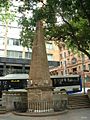
Macquarie Place was Sydney's first planned public space in 1810. It was like the town square back then. Along with Hyde Park, it's the oldest public park in Australia! The park is smaller now than it used to be. The Obelisk, built in 1818, was designed by Francis Greenway, a famous architect. It was used to measure distances to other towns in New South Wales. Later, an anchor and a cannon from the First Fleet flagship, HMS Sirius, were placed here. The start of the Great North Walk to Newcastle is at the Obelisk.
Many important places started near Macquarie Place. In 1817, Australia's first bank, the Bank of New South Wales (now Westpac), opened here. The State Library of New South Wales was also here for a short time in the 1830s.
In 1883, a statue of Thomas Sutcliffe Mort, an early Australian businessman, was put in the park. In 1954, Queen Elizabeth II and the Duke of Edinburgh planted two trees in the park. This marked the start of the Remembrance Driveway.
Contents
History of Macquarie Place
This area was originally a swampy mangrove land next to the Tank Stream, which was Sydney's first water supply. It was a very important spot! In 1792, a path from Bridge Street met the road to the First Government House right here. This was close to the water's edge back then.
Maps from 1792 and 1793 show Macquarie Place as a triangular area next to the First Government House garden. It was near Circular Quay (then called Sydney Cove) and the Tank Stream. The triangle shape came from the natural land and where three early roads met. These roads connected important buildings like the Guard House, a bridge over the Tank Stream, and early forts. Macquarie Place might have been a public meeting spot as early as 1791.
By 1807, the triangular shape was officially set, and a guard house was built near the main entrance of Government House.
Macquarie's Vision for Sydney
In 1810, Governor Macquarie officially named Sydney's main roads and set aside Macquarie Place as a public area. He wanted Sydney to have a clear, organised layout. During his time (1810–1821), many new towns and roads were built, pushing further into the country. Bathurst Plains were opened up with a road over the Blue Mountains in 1814-15.
Macquarie's wife, Elizabeth Macquarie, helped him plan public spaces. She knew a lot about designing beautiful landscapes. She and architect Francis Greenway had big ideas for Sydney. They wanted to create pretty parks and design buildings carefully to make the city look grand. This style of landscaping was popular in English country estates at the time.
Elizabeth Macquarie helped bring landscape gardening to Australia. As the Governor's wife, she influenced the design of public buildings. The Macquaries changed the Sydney and Parramatta areas to look more like a picturesque garden.
Governor Macquarie hired Francis Greenway, a convict architect, in 1814. Greenway was made the Acting Government Architect in 1816. He designed many important buildings and planned landscaped gardens. Of his grand plans for Sydney, only the stables (now the Conservatorium of Music) and the Obelisk in Macquarie Place remain. Convicts helped clear and level the park area.
Macquarie Place was the first planned town square in Sydney. It was also the very centre of the early Colony, marked by the Obelisk built there in 1818. Governor Macquarie was responsible for its official layout, making it a very important spot. The park and its memorials show how Sydney has grown since it was founded.
Macquarie Place separated the town from the Governor's private land, which included the First Government House. So, Macquarie Place was the boundary between the Governor's property and the homes of important officials and wealthy citizens. This park, with the Obelisk, was Sydney's main town square. Many artists, like Conrad Martens, drew it in the early days. This land was officially named Macquarie Place in 1810.
The Obelisk: Sydney's Zero Point
The Obelisk is the oldest surviving milestone in Australia. It was built to mark the spot from where all public roads in the Colony were measured. It's the second oldest known European monument in Australia. The oldest is an obelisk from 1811 at Watsons Bay. The Macquarie Obelisk was designed to make the entrance to Government House look grand and to create beautiful views. It was once easily seen from many parts of early Sydney.
Obelisks were originally sacred symbols in ancient Egypt. Later, they were used in Roman public squares and then by Renaissance designers to mark special spots. English gentlemen on "Grand Tours" saw them and brought the idea back to England. Elizabeth Macquarie and Francis Greenway likely got their ideas from these European examples.
Governor Macquarie had the sandstone Obelisk built in Macquarie Place in 1818. It marked the starting point for measuring all roads as the colony expanded. "New South Wales" on maps back then covered a huge area, but the Obelisk's inscriptions show how small the actual settled colony was in 1818. It only listed distances to places like Bathurst, Windsor, Parramatta, Liverpool, and Botany Bay. This was still a big step for Sydney, as roads had only gone about 40 miles inland before Macquarie became Governor. The Obelisk is truly the "hub" of NSW, the point from which all distances in the state were measured from Sydney.
The Obelisk was the "zero point" for measuring road distances from Sydney starting in 1818. It was key to surveying, mapping, and planning the colony's growth. Surveyors like John Oxley and James Meehan used it to lay out new roads. Even today, many roads from Sydney are still measured from the Macquarie Obelisk.
Francis Greenway designed the Obelisk, and stonemason Edward Cureton built it between 1818 and 1820. Greenway was a former convict who became a very important architect. He based his design on a similar obelisk in Bath, England. The sandstone used for the Obelisk was quarried locally, but its exact source is unknown. It's unique because no other buildings in Sydney are made from this specific type of fine white sandstone. Unlike most obelisks, this one was built from many sandstone blocks, not a single piece, because the technology to cut a single large block wasn't available in colonial Sydney.
The Obelisk shows Governor Macquarie's big plans for the colony. He wanted Sydney to be a proper city, not just a prison outpost. The British Government, however, thought his projects were too grand for a penal settlement. Commissioner Bigge, sent from England, even found the Obelisk too fancy. Governor Macquarie strongly defended it, calling it a "little unadorned Obelisk" that was "somewhat ornamental to the Town" and not too expensive.
The Obelisk and Macquarie Place are rare examples of Macquarie's efforts to build Sydney as a Georgian town with a planned layout and elegant buildings. Other examples include the Hyde Park Barracks and St James Church. They show how Sydney changed from a rough settlement to a planned city under Governor Macquarie.
The Obelisk also shows that even ex-convicts like Francis Greenway could succeed. Greenway was sentenced to death for forgery but was sent to New South Wales instead. In 1816, Governor Macquarie made him the first Colonial Architect.
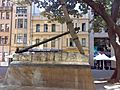
The Greenway Fountain
In 1819, Macquarie also asked Greenway to design a fountain. It was located at the western corner of the park, where the statue of T. S. Mort is now. It was outside the fenced area so everyone could use it, and it was as far from Government House as possible while still looking nice. Macquarie Place today is about half its original size.
Elizabeth Macquarie was very involved in the fountain's design. She even had a large part of it rebuilt when she didn't like how it looked. The fountain caused some arguments, with people saying Macquarie was spending too much money. Macquarie strongly defended it.
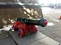
The Sirius Anchor and Cannon
Macquarie Place also has items from the first defenses of the Colony. The salvaged anchor and cannon from the Sirius are still in the park. The Sirius was the main warship that brought the First Fleet to Australia in 1788. It was wrecked off Norfolk Island in 1790.
The Sirius cannon and anchor have been in Macquarie Place for over a hundred years. The iron cannon was made in England between 1767 and 1786. It was brought ashore from the Sirius in 1788 or 1796 to help defend the new colony and signal ships.
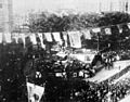
The cannon was moved to Macquarie Place in the 1880s. In 1905, the anchor of the Sirius was found from the wreck and placed in the park with the cannon in 1907.
Macquarie Place was also the site of Sydney Cove's first defenses, called the First Redoubt, built from 1788-1791. This was a temporary fort. The park became its current size in the 1830s when Loftus Street was built, making the park smaller.
The park has many old trees, including fig trees from a planting plan in the 1860s.
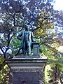
Statue of Thomas Sutcliffe Mort
In the 1880s, large government buildings were built around Bridge Street. The fountain was removed around 1887 to make way for the statue of Thomas Sutcliffe Mort.
The bronze statue of Thomas Sutcliffe Mort, who died in 1878, shows the growth of business and industry in Sydney. The inscription on the statue says he was "A pioneer of Australian resources, a founder of Australian industries." He was one of the first people in Australia to make it possible to export food using refrigeration. He also helped build the shipping industry. His statue represents Sydney becoming a proud, growing city.
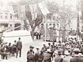
The statue was put up in 1883. It replaced the older fountain from 1819-1820. There might still be parts of the old fountain buried underground beneath the statue. Hundreds of workers, who gave up a day's pay, came to see the statue unveiled as a tribute to their former boss.
Thomas Mort (1816–1878) came to NSW in 1838 and became a successful auctioneer, especially in wool sales. He used his wealth to pursue his love for gardening, creating a famous garden called Greenoaks. He was also the President of the NSW Horticultural Society.
By the 1890s, tall trees made it hard to see the Obelisk. The park was redesigned in the 1930s. Around 1910, a wrought iron fence was removed, and some fig trees were taken out. During World War I, the area around the Obelisk was changed, and Loftus Street was raised, requiring new stairs.
In 1954, Queen Elizabeth II and the Duke of Edinburgh planted two London Plane trees in Macquarie Place. These trees remember their first visit to Australia and mark the start of the Remembrance Driveway to Canberra.
Other memorials in the park include an 1857 drinking fountain (moved here in the 1970s) and a 1908 domed public toilet (now partly an archaeological site).
Fountain and Pond by Gerald Lewers
In 1960, a small bronze fountain was added to the park. It was designed by sculptor Gerald Lewers to remember an Australian sculptor, Lieutenant John Christie Wright, who died in France in 1917. The wall and steps around the Obelisk were also built at this time.
Around 1970, a truck hit the Obelisk, damaging its base. The new letters carved into the replacement panels are not as good as the original ones. In 1976, more changes were made, including extending the park's western corner and changing pathways. Macquarie Place was closed to cars, and the iron drinking fountain was moved.
Even though the park is smaller now, it has been a public space since 1810. Its design and levels have changed, but the Obelisk is still in its original spot. Today, tall buildings and trees surround the park. In 2006, Sydney City Council spent $450,000 to help restore the Obelisk.
What You Can See in Macquarie Place
Macquarie Place is a triangular public space. It has a low sandstone wall on two sides.
The park has many mature trees. You'll see three plane trees along Loftus Street, two Moreton Bay figs on the western side, and an evergreen oak with two clumps of Lord Howe Island palms and soft tree ferns on the Bridge Street side. There's also a young weeping lily pilly tree.
The park used to be about twice its current size but became smaller between 1836 and 1843 when Loftus Street was built.
The park has several important monuments and memorials:
- The Obelisk
This sandstone obelisk was designed by Francis Greenway and built by Edward Cureton between 1816 and 1818. It was made to decorate Sydney's first public square and to mark the spot from where all public roads in the colony were measured. It's truly the "hub" of NSW, the starting point for all distances measured from Sydney. Its carvings show how far the road network reached in 1818.
The Obelisk has a Georgian design with Greek revival details. It looks like a tall pyramid on a square base with decorative edges. The base has the original inscriptions and is surrounded by a low stone wall with a simple wrought iron fence. It's made of sandstone, likely from a local quarry, but its exact location is unknown. No other buildings in Sydney are made from this specific fine white sandstone.
The letters on the Obelisk are carved and blackened, in a Roman style typical of the Georgian period. They show distances to important settlements in 1818, like Bathurst, Windsor, Parramatta, and Liverpool.
- The Sirius Anchor and Cannon
These are parts of the HMS Sirius, the main ship of the First Fleet, which was wrecked in 1790. The bronze statue of Thomas Sutcliffe Mort, who died in 1878, has an inscription saying he was "A pioneer of Australian resources, a founder of Australian industries, one who established our wool market." You'll also see 1869 sandstone gate posts facing Bridge Street, marked with "Walter Renny, Esq., Mayor 1869," remembering a former Mayor of Sydney. Other old public memorials include a 1908 domed public toilet (now partly an archaeological site) and an 1857 cast iron drinking fountain. A small bronze fountain by sculptor Gerald Lewers was added in 1960. Two London Plane trees were planted in 1954 by Queen Elizabeth II and the Duke of Edinburgh. These trees mark the start of the Remembrance Driveway to Canberra.
- Archaeological Remains
There might be buried parts of the old fountain designed by Francis Greenway and Mrs Macquarie. This fountain was built by Edward Cureton around 1819-1820 and provided water to local residents. It was taken down around 1887 to make way for the Thomas Mort statue.
- Thomas Sutcliffe Mort Statue
This statue, from around 1887, looks out over Bridge Street, Sydney's main financial street. It honors businessman and horticulturist Thomas Sutcliffe Mort (1816–1878). He came to NSW in 1838 and became a successful auctioneer, especially in wool sales. He used his wealth to create a famous garden called Greenoaks. Mort was also a leader in the NSW Horticultural Society.
- Memorial Gate Pillars
These sandstone gate pillars facing Bridge Street remember Walter Renny, who was the Mayor of Sydney in 1869.
- Fountain and Pond by Gerald Lewers
This fountain remembers Australian sculptor Lieutenant John Christie Wright, who died at age 28 in France in 1917.
Condition of the Park
As of 2005, the trees, monuments, and the park itself were generally in good condition. The City of Sydney Council was working on restoring and maintaining the Obelisk.
The site might also hold archaeological clues about early Sydney. This is rare because most old sites in Sydney have been built over. Macquarie Place has remained largely undeveloped since 1814, making it special.
The Obelisk is mostly original but needs some restoration. The Heritage Council is helping the City of Sydney Council with this.
Changes Over Time
Macquarie Place has changed a lot since Governor Macquarie's time. Here are some key changes:
- 1792: Maps show Macquarie Place as a triangular area.
- 1793: The triangular shape was influenced by the natural land and early roads.
- 1807: The triangular layout was made official, and a guard house was built.
- 1810: Governor Macquarie officially set aside Macquarie Place as public land.
- 1818/19: The Obelisk and Doric Fountain were built. The park had paths leading to the Obelisk and a low wall around it.
- 1830s: The park's size was reduced.
- 1869-1910: Various monuments were added.
- 1910: Changes included fewer fig trees.
- 1954: Two Plane trees were planted by Queen Elizabeth II and the Duke of Edinburgh.
- 1960: A new fountain was added.
- 1976: More changes were made, including closing Macquarie Place to cars.
Why Macquarie Place is Important
Macquarie Place is one of the most historically important urban spaces in Sydney and Australia. It was created less than 25 years after the First Fleet arrived. The park and its monuments show how Sydney developed from its very beginnings. It was Sydney's first main town square, located next to the First Government House (which is no longer there) and near the original Sydney Cove shoreline.
The Obelisk, built in Macquarie Place in 1818, was the geographic centre of Sydney and the Colony in the 1800s. It marked the spot from where all public roads were measured for over 190 years. The park and Obelisk were famous landmarks in colonial Sydney and appeared in many old paintings.
Even though Macquarie Place's original importance as the main town square and centre of the Colony is less obvious today due to surrounding changes, the park and its monuments are still a strong link to Sydney's earliest history. It might even be the only remaining part of the original Sydney Cove shoreline that hasn't changed much in over 200 years. This means it can represent the first meeting place between Aboriginal people of the Eora Country and British settlers in 1788.
Macquarie Place is the oldest planned town square in Australia. Along with Hyde Park, it's also the oldest urban park in Australia and has been used continuously as a public space for at least 195 years. The Obelisk is the oldest milestone for measuring roads in Australia and the second oldest European monument. The inscriptions on the Obelisk show how small the colony was in 1818 when it first started expanding inland. The Obelisk was also a "symbolic peg" showing how far the British Empire reached in the early 1800s.
Macquarie Place and the Obelisk show how the Colony changed from a rough prison settlement to a planned town under Governor Macquarie. This change is seen in the Obelisk's role in expanding the Colony, creating a formal centre, and the high quality of the park and monument design. The Obelisk and Macquarie Place are great examples of Georgian style planning and design in Sydney. They are rare surviving parts of Macquarie's plan for Sydney, along with Hyde Park Barracks and St James Church. The Obelisk was designed by Francis Greenway, a famous architect, and built by Edward Cureton with convict labor.
These features show Macquarie's vision for a permanent, planned settlement, which was much bigger than the British Government's idea of NSW as just a prison. When the Obelisk was built, Commissioner Bigge, representing the British Government, thought it was too grand for a penal colony. Governor Macquarie defended it, saying it was "little unadorned" and "somewhat ornamental." This disagreement about spending money on a prison colony contributed to Governor Macquarie's resignation, meaning many of his and Greenway's plans for an elegant Georgian town were never finished.
The Sirius cannon and anchor in Macquarie Place are rare items from the First Fleet's main warship, which arrived in Sydney Cove in 1788. Both have been in Macquarie Place for over a century. Macquarie Place was also the site of Sydney Cove's first defenses, called the First Redoubt, built from 1788-1791.
Later monuments in Macquarie Place show the park's continued importance and Sydney's growth in planning, services, and industry since colonial times. The statue of Thomas Sutcliffe Mort shows the growth of business, especially the wool industry. The 1869 stone gate posts remember Mayor Walter Renny. The 1908 domed public toilet shows improvements in public health and city design. The London Plane trees planted by Queen Elizabeth II and the Duke of Edinburgh in 1954 remember their visit and mark the start of the Remembrance Driveway to Canberra. The bronze fountain by Gerald Lewers remembers Australian sculptor John Christie Wright.
Macquarie Place Precinct was listed on the New South Wales State Heritage Register on 5 March 2010 because it meets several important criteria:
- It shows the history of New South Wales.
Macquarie Place is one of the most important historical urban spaces in Sydney and Australia. It has many monuments that show Australia's history from its beginning. It was Sydney's first main town square and a part of the original Sydney Cove area. The Obelisk and Macquarie Place mark the geographic centre of the Colony in the early 1800s and are rare reminders of early Sydney and Governor Macquarie's planning.
- It is linked to important people in New South Wales history.
The Obelisk was designed by Francis Greenway, a famous architect (and former convict), and built by Edward Cureton with convict labor. It was one of Greenway's first major projects after he became the first Colonial Architect. Macquarie Place and the Obelisk are strongly linked to Governor Macquarie and his plans for the colony. They represent the difference between Macquarie's vision for a permanent settlement and the British Government's view of the Colony as just a prison.
- It shows great design and creativity.
The Obelisk and Macquarie Place are rare examples of Governor Macquarie's Georgian town plan for Sydney, which aimed for a planned layout and elegant buildings in a picturesque setting. They are fine examples of early colonial planning and urban design. Macquarie Place is also a good example of triangular parks and street patterns from the early colonial period that followed the natural shape of the land. The Obelisk's design is an early example of the Neo-Classical style, possibly influenced by Bath, England.
- It is important to the community.
Macquarie Place is an important green space in Sydney's city centre, offering a nice area for people to relax. Historically, it was Sydney's main town square, a popular place for early citizens to walk around. Its continuous use as a public space for over 200 years makes it socially significant.
- It can teach us about history.
The Obelisk is important for research because it was the central point for measuring highways built in New South Wales from 1818. It's a well-preserved example of a marker stone used for this purpose for a long time. The site also has the potential for archaeological remains from before 1814, which could help us understand early Sydney. This is rare because most archaeological sites from that period have been destroyed by later development.
- It has rare or unique features.
Macquarie Place and the Obelisk are very rare examples of early Sydney's development and planning. They show Governor Macquarie's vision for a permanent settlement, which started Sydney's change from a rough prison to a planned town. They are rare evidence of the early colonial town centre where roads were measured, the colony was governed, and the First Fleet landed.
Macquarie Place is the first planned town square in Australia, officially named in 1810. It's also the oldest urban park in Australia, along with Hyde Park, and has been continuously used for over 195 years. The Obelisk is the second oldest surviving European monument in Australia, dating from 1818, and is very rare as the first and oldest "zero point" milestone for measuring public roads.
The inscriptions on the Obelisk are also rare because they are a physical record of the colony's size at a specific time, showing its expansion inland. The Obelisk is a rare example of Francis Greenway's work, and it's one of the few of his designs that were actually built and still survive. It's also one of the few remaining convict-built structures in the inner city.
The Sirius anchor and cannon are rare items from the First Fleet's flagship, representing Australia's earliest European settlement and defense.
- It shows the main features of similar places in New South Wales.
The Obelisk and Macquarie Place represent the geographic and symbolic centre of Sydney during the early colonial period. The triangular shape of Macquarie Place shows early town planning in Sydney, where streets followed the natural land, rather than a strict grid. The remaining fig trees show the street planting style of the time.
The Obelisk is an example of markers used as starting points for measuring distances in major cities. It was the "zero point" for roads from Sydney until the General Post Office took over this role. Macquarie Place and the Obelisk are fine examples of early colonial planning and urban design based on Governor Macquarie's and Francis Greenway's plans for an elegant Georgian town.
Gallery
-

Gateway Plaza building at 1 Macquarie Place.
-
The Macquarie Obelisk.
-
The anchor from HMS Sirius as it stands today.
-
Cannon from HMS Sirius.
-
The statue of Thomas Mort that was unveiled in 1883
-
Unveiling of HMS Sirius' anchor at Macquarie Place in 1907
-
Unveiling of the Thomas Mort statue in Macquarie Place, 1883
-
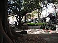
Macquarie Place in 2019


Images for kids
-

Macquarie Place Park in 2019
-
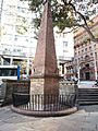
The Obelisk in Macquarie Place Park


