Madeira Beach, Florida facts for kids
Quick facts for kids
Madeira Beach, Florida
|
|
|---|---|
| City of Madeira Beach | |

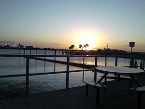
Sunset at Madeira Beach
|
|
| Nickname(s):
Mad Beach
|
|
| Motto(s):
"Two Miles Long and a Smile Wide"
|
|

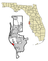
Location in Pinellas County and the state of Florida
|
|
| Country | |
| State | |
| County | Pinellas |
| Incorporated (town) | May 5th, 1947 |
| Incorporated (city) | August 8th, 1951 |
| Government | |
| • Type | Commissioner-Manager |
| Area | |
| • Total | 3.19 sq mi (8.27 km2) |
| • Land | 0.98 sq mi (2.54 km2) |
| • Water | 2.21 sq mi (5.72 km2) |
| Elevation | 3 ft (1 m) |
| Population
(2020)
|
|
| • Total | 3,895 |
| • Density | 3,966.40/sq mi (1,531.69/km2) |
| Time zone | UTC-5 (Eastern (EST)) |
| • Summer (DST) | UTC-4 (EDT) |
| ZIP codes |
33708, 33738
|
| Area code(s) | 727 |
| FIPS code | 12-42400 |
| GNIS feature ID | 0286267 |
Madeira Beach (pronounced mə-DAIR-ə) is a city in Pinellas County, Florida. It is located on the west side of Florida, right next to the Gulf of Mexico. To its east is the city of St. Petersburg. In 2020, about 3,895 people lived here.
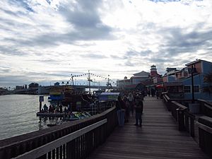
A popular area called John's Pass is part of Madeira Beach. It's a fun place located on the Intracoastal Waterway. Locals often call the city "Mad Beach." The city gets its name from a beautiful island in Portugal called Madeira.
Contents
History of Madeira Beach
Before Europeans arrived, the area that is now Madeira Beach was not a permanent home for people. The local Tocobaga tribe used the land to gather seafood. However, they did not live there all the time.
The way Madeira Beach looks today was largely shaped by a big storm. In 1848, a powerful hurricane, known as the "Gale of '48," created a new waterway. This waterway is now called John's Pass. It was named after an early settler, John (Juan) Levique.
There were a few tries to settle the area in the early 1900s, but they didn't last. In 1926, a special road called a causeway was built. This road connected the mainland to Madeira Beach. After that, the first houses could be built in the area. A year later, a bridge was built over John's Pass.
Madeira Beach officially became a town in May 1947. In 1951, it added the nearby area of South Madeira. In the 1950s and 1960s, the land area of Madeira Beach grew a lot. This happened because of major "dredging" work. Dredging means digging up sand and dirt from the water to create more land. Also, in 1955, the town added some land on the mainland. This was for building a shopping center and a school, which is now Madeira Beach Fundamental School.
Many new buildings, like beach condos and hotels, were built in the 1970s and 1980s. Today, Madeira Beach is still a quiet beach town. It is a popular spot for people to visit on vacation.
Geography of Madeira Beach
Madeira Beach is located at about 27.795853 degrees North and 82.790623 degrees West.
The city covers a total area of about 3.3 square miles (8.27 square kilometers). About 1.0 square mile (2.54 square kilometers) of this is land. The rest, about 2.2 square miles (5.72 square kilometers), is water. This means a large part of the city's area is water!
Madeira Beach is on a barrier island. This is a long, narrow island that protects the mainland from ocean waves. The Gulf of Mexico is to the southwest. To the northeast is the Boca Ciega Bay. One bridge, the Tom Stuart Causeway, connects Madeira Beach to the mainland. This mainland area is called Bay Pines. To the northwest of Madeira Beach is the town of Redington Beach. To the southeast, across John's Pass, is the city of Treasure Island.
Climate
Madeira Beach has a humid subtropical climate. This means it has mild winters and hot, humid summers. It gets rain throughout the year.
Population and People
| Historical population | |||
|---|---|---|---|
| Census | Pop. | %± | |
| 1950 | 916 | — | |
| 1960 | 3,943 | 330.5% | |
| 1970 | 4,177 | 5.9% | |
| 1980 | 4,520 | 8.2% | |
| 1990 | 4,225 | −6.5% | |
| 2000 | 4,511 | 6.8% | |
| 2010 | 4,263 | −5.5% | |
| 2020 | 3,895 | −8.6% | |
| U.S. Decennial Census | |||
In 2020, there were 3,895 people living in Madeira Beach. There were 2,001 households and 1,310 families. In 2010, the city had 4,263 people and 2,278 households.
Fun Places to Visit
The Chicken Church
Madeira Beach is home to the Church By The Sea. This church welcomes people from many different Christian backgrounds. It serves the beach towns nearby, like Treasure Island and Redington. The church was built between 1944 and 1946.
Many tourists visit this church because its tower looks like a chicken! Because of this, it is often called the "Chicken Church."
John's Pass Marina
On September 24, 1848, a very strong hurricane hit the west coast of Florida. This storm split the barrier island and created the waterway we now know as John's Pass. John Levique, along with Joseph Silva, found this new passage and named it after John. Today, it is a canal owned by the federal government.
In 2022, the Governor of Florida, Ron DeSantis, set aside $1,500,000 in the budget. This money was for "dredging" John's Pass. This means making the waterway deeper so boats can pass through more easily.
See also
 In Spanish: Madeira Beach para niños
 | Georgia Louise Harris Brown |
 | Julian Abele |
 | Norma Merrick Sklarek |
 | William Sidney Pittman |


