Maiden Island facts for kids
| OS grid reference | NM847319 |
|---|---|
| Coordinates | 56°25′50″N 5°29′33″W / 56.4305°N 5.492532°W |
| Physical geography | |
| Island group | Firth of Lorn |
| Area | 3 ha (7 acres) |
| Highest elevation | 28 m (92 ft) |
| Administration | |
| Sovereign state | United Kingdom |
| Country | Scotland |
| Council area | Argyll and Bute |
| Demographics | |
| Population | 0 |
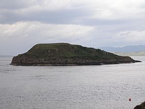
Maiden Island is a small island off the west coast of Scotland. It is located right at the mouth of Oban Bay. No one lives on this tiny island.
Exploring Maiden Island's Location
Maiden Island is very close to the mainland of Scotland. It sits west of Dunollie Castle and Camas Bàn. The island is just north of the narrow entrance to Oban Bay. It is also about 0.5 kilometers (0.3 miles) north of the bigger island of Kerrera.
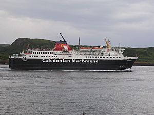
The water channel between Maiden Island and Kerrera is quite deep. This means large ships, like the Caledonian MacBrayne ferry MV Isle of Mull, use this path often. Maiden Island itself rises about 28 meters (92 feet) above the sea.
From Maiden Island, you can see the Hutchison Memorial. This tall monument is on the north end of Kerrera. It honors David Hutchison, who helped start the Caledonian MacBrayne ferry company.
The Story Behind the Name
There are a few interesting stories about how Maiden Island got its name. One idea connects it to King Malcolm IV of Scotland. He ruled from 1153 to 1165 and was sometimes called "Malcolm the Maiden." He had links to the nearby island of Kerrera.
Another, simpler explanation is that many Scottish islands share this name. It might have been a safe place for women during times of war.
Shipwrecks Near Maiden Island
Maiden Island has been part of some important events. On December 23, 1940, during World War II, a group of ships near Lismore were attacked. Two German planes, called Heinkel He 111 bombers, caused damage.
A cargo ship named the Breda was hit. It had to be moved to a nearby bay called Ardnamucknish Bay. Pieces from the damaged ship floated into Oban Bay. Four days later, a Sunderland Flying Boat from 210 Squadron was trying to land in the dark. It hit a large object floating in the water. The aircraft broke apart and sank right off Maiden Island. Sadly, only one person survived from the 11 crew members on board.
 | Jewel Prestage |
 | Ella Baker |
 | Fannie Lou Hamer |


