
Mammern facts for kids
Quick facts for kids
Mammern
|
||
|---|---|---|
 |
||
|
||

Mammern
Location in Switzerland

Mammern
Location in Canton of Thurgau
|
||
| Country | Switzerland | |
| Canton | Thurgau | |
| District | Frauenfeld | |
| Area | ||
| • Total | 5.44 km2 (2.10 sq mi) | |
| Elevation | 400 m (1,300 ft) | |
| Population
(Dec 2020 )
|
||
| • Total | 677 | |
| • Density | 124.45/km2 (322.3/sq mi) | |
| Postal code |
8265
|
|
| Surrounded by | Eschenz, Herdern, Homburg, Hüttwilen, Öhningen (DE-BW), Steckborn | |

Mammern is a small town, also called a municipality, in the Frauenfeld District of Thurgau canton in Switzerland. It is located right on the beautiful Lake Constance.
Contents
History of Mammern
People have lived in the Mammern area for a very long time! We know this from things found from the Neolithic Age (New Stone Age), the Bronze Age, and the Early Middle Ages. These finds include old stilt houses and stone tools.
The name "Mammern" was first written down in the year 909. At that time, St. Gallen Abbey, a powerful monastery, took control of Mammern. They ruled Mammern and a nearby place called Neuburg until the 12th century. Over the years, the villages were bought and sold by different families and groups.
In 1621, the von Roll brothers rebuilt the castle in Mammern. Later, in 1687, Rheinau Abbey took over the land rights. They controlled the village until 1798. From 1803 to 1992, Mammern was part of the larger town of Steckborn.
A church was built in Mammern before 1275 by St. Gallen Abbey. The right to collect church taxes and choose priests stayed with the abbey for a long time. In 1529, the Protestant Reformation brought new religious ideas to the village. The Catholic Church later tried to bring people back to their faith. In 1749, a beautiful Baroque chapel was built near the castle. After a fire in 1909, new churches were built: a Reformed church in 1911 and a Catholic church in 1913.
In the past, Mammern's economy relied on farming, growing grapes for wine, and raising animals. People also fished, ran taverns, and worked in mills. There was even a brick factory and a lime kiln. Later, a furniture factory opened in 1878, and a match factory in 1910. In 1865, a special health clinic opened in the castle. It helped people with heart and body problems.
Geography of Mammern
Mammern covers an area of about 5.42 square kilometers (about 2.1 square miles). A large part of this land is used for farming (45%). Forests cover another big part (43%). Buildings and roads make up about 11.8% of the area. There are also a few small rivers or lakes.
The town is located in the Frauenfeld District, right on the Untersee, which is a part of Lake Constance. It's about 4 kilometers (2.5 miles) east of Stein am Rhein. Mammern includes the main village and two smaller settlements called hamlets: Klingenzell and Neuburg.
Population and People
Mammern has a population of about 585 people. About 22.9% of the people living here are from other countries. Over the last ten years, the population has grown a little. Most people in Mammern speak German (87.1%). Portuguese is the second most common language (3.9%), followed by Albanian (2.1%).
The age of people in Mammern varies. About 11% of the population are children aged 0-9, and 13.5% are teenagers aged 10-19. Many adults are between 40 and 49 years old (19.7%). There are also many older people, with about 8.9% aged 60-69 and 7.4% aged 70-79.
In the 2007 national election, the SVP was the most popular party, getting almost 46% of the votes.
Here's how the population of Mammern has changed over the years:
| year | population |
|---|---|
| 1850 | 322 |
| 1860 | 312 |
| 1870 | 280 |
| 1880 | 326 |
| 1890 | 364 |
| 1900 | 398 |
| 1950 | 401 |
| 1960 | 424 |
| 1980 | 392 |
| 1990 | 484 |
| 2000 | 533 |
Important Heritage Sites
Mammern has some very important historical places! The castle with its park and chapel, and the Mariahilf pilgrimage church in Klingenzell, are listed as Swiss heritage sites of national importance. This means they are very special and protected.
The village of Mammern itself, along with the Eschenzer Basin, is also part of the Inventory of Swiss Heritage Sites.
-
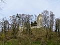
Ruins of Mammern Neuburg Castle
-
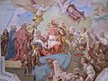
Painting from the castle church


Mammern's Economy
In 2007, Mammern had a very low unemployment rate, meaning most people who wanted to work had jobs.
The economy of Mammern is divided into three main parts:
- Primary sector: This includes farming and forestry. About 41 people work in this area.
- Secondary sector: This involves making things, like in factories. About 7 people work here.
- Tertiary sector: This is the service industry, like shops, hotels, and the health clinic. This is the biggest part of Mammern's economy, with 325 people working in this area.
Many people who live in Mammern also travel to other towns for work. About 8.1% use public transport, and 43.5% drive their own cars.
Religion in Mammern
According to a census from 2000, about 36.6% of the people in Mammern were Roman Catholic. Another 43.5% belonged to the Swiss Reformed Church. There are also smaller groups of people who follow other Christian churches or Islam. About 9.57% of the population said they did not belong to any church.
Transport
Mammern is located on the Lake Line railway, which connects Schaffhausen and Rorschach. The town has its own train station, Mammern railway station, which is part of the St. Gallen S-Bahn network.
Education in Mammern
Switzerland is known for its good education system. In Mammern, about 74.1% of adults (aged 25 to 64) have finished high school or gone on to higher education, like a university.
Mammern has its own primary school district. There are about 53 students in kindergarten and primary school. The average class size in primary school is about 13-14 students.
Images for kids
-
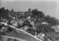
Aerial view of Mammern from 100 meters, taken by Walter Mittelholzer in 1919.
See also
 In Spanish: Mammern para niños
