
Manu Temple facts for kids
Quick facts for kids Manu Temple |
|
|---|---|

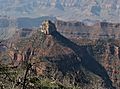
Manu Temple centered, south aspect
(Buddha Temple left, Oza Butte upper right) |
|
| Highest point | |
| Elevation | 7,184 ft (2,190 m) |
| Prominence | 524 ft (160 m) |
| Isolation | 1.26 mi (2.03 km) |
| Parent peak | Buddha Temple (7,212 ft) |
| Geography | |

Manu Temple
Location in Arizona

Manu Temple
Location in the United States
|
|
| Location | Grand Canyon National Park Coconino County, Arizona, US |
| Parent range | Kaibab Plateau Colorado Plateau |
| Topo map | USGS Bright Angel Point |
| Type of rock | sandstone, limestone, mudstone |
| Climbing | |
| Easiest route | class 4 climbing |
Manu Temple is a tall rock formation, or summit, found in the amazing Grand Canyon. It stands 7,184 feet (2,190 meters) high in northern Arizona, United States. This impressive natural landmark is located in Coconino County.
Manu Temple is about one mile south of Widforss Point on the North Rim of the Grand Canyon. It's also near its "parent" peak, Buddha Temple, which is 1.5 miles (2.4 km) away. The peak rises dramatically from the canyons around it. For example, it soars nearly 3,600 feet (1,100 meters) above Bright Angel Canyon to its east.
It can be tricky to spot Manu Temple from the South Rim of the Grand Canyon. This is because it blends in with the Kaibab Plateau behind it. But on clear days, you can see this huge butte standing out clearly.
Contents
How Manu Temple Got Its Name
Manu Temple was named by a person called George Wharton James. He named it after Manu, who was an important lawgiver in Hindu stories. This naming style was a tradition started by Clarence Dutton. He liked to name Grand Canyon features after gods and figures from myths.
The name "Manu Temple" became official in 1906. This decision was made by the U.S. Board on Geographic Names.
Weather Around Manu Temple
The area where Manu Temple is located has a Cold semi-arid climate. This means it's usually dry, but not a true desert. It gets some rain, but not a lot.
Any rain that falls on Manu Temple flows south. It drains into the mighty Colorado River. On the east side, the water goes into Bright Angel Creek. On the west side, it flows into Phantom Creek.
What Manu Temple Is Made Of
The very top of Manu Temple is made of a rock called Coconino Sandstone. This sandstone is cream-colored and forms steep cliffs. It's one of the younger rock layers in the Grand Canyon. This sandstone formed about 265 million years ago from ancient sand dunes.
Below the Coconino Sandstone, you'll find other layers of rock. These include the Hermit Formation, which is a slope-forming rock. Underneath that is the Supai Group. Even further down are layers of Redwall Limestone, the Tonto Group, and finally the Unkar Group near the bottom of the canyons.
Gallery
-
Manu Temple from Widforss Point
-
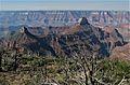
Buddha Temple and Manu Temple (left) from Widforss Point
-
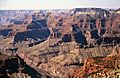
Buddha and Manu Temples, east aspect from Komo Point.


