
Buddha Temple facts for kids
Quick facts for kids Buddha Temple |
|
|---|---|

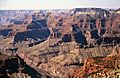
South aspect
|
|
| Highest point | |
| Elevation | 7,212 ft (2,198 m) |
| Prominence | 766 ft (233 m) |
| Isolation | 1.46 mi (2.35 km) |
| Parent peak | The Colonnade (7,602 ft) |
| Geography | |

Buddha Temple
Location in Arizona

Buddha Temple
Location in the United States
|
|
| Location | Grand Canyon National Park Coconino County, Arizona, US |
| Parent range | Kaibab Plateau Colorado Plateau |
| Topo map | USGS Bright Angel Point |
| Type of rock | limestone, sandstone, mudstone |
| Climbing | |
| First ascent | 1973 |
| Easiest route | class 5.4 climbing |
Buddha Temple is a tall peak, 7,212 feet (2,198 meters) high, located in the amazing Grand Canyon. You can find it in Coconino County, in northern Arizona, USA.
This mountain is about 6.5 miles (10.5 km) north of Mather Point, a popular spot on the Grand Canyon's South Rim. It's also four miles southwest of Bright Angel Point on the North Rim. Buddha Temple stands out because it rises very high above the surrounding canyons. It climbs over 3,800 feet (1,160 meters) in just two miles above Bright Angel Canyon to the east. To the west, it rises 3,000 feet in less than a mile above Haunted Canyon.
Buddha Temple has several interesting neighbors. These include Manu Temple to the northeast, Isis Temple to the southwest, Zoroaster Temple to the southeast, and Deva Temple to the east.
Contents
How Buddha Temple Got Its Name
Buddha Temple was named by Henry Gannett. He was a geographer working with Clarence Dutton. Dutton liked to name features in the Grand Canyon after gods and goddesses from different myths. So, following this idea, Gannett named this peak after Buddha.
The name "Buddha Temple" was officially accepted in 1906 by the United States Board on Geographic Names. This board is in charge of naming places in the USA.
First Climbers to Reach the Top
The very first time someone successfully climbed to the top of Buddha Temple was in 1973. The climbers were Bruce Grubbs, Chauncey Parker, and Mark Brown. They used a route called the Northwest Arete.
The Rocks and Layers of Buddha Temple
The top part of Buddha Temple is made of a hard rock called Kaibab Limestone. This limestone forms a protective "caprock" over the layers below.
Right under the limestone is a cream-colored rock called Coconino Sandstone. This sandstone forms steep cliffs. It was made about 265 million years ago from ancient sand dunes.
Below the Coconino Sandstone, you'll find other rock layers:
- The Permian Hermit Formation, which forms slopes.
- The Pennsylvanian-Permian Supai Group.
- The Mississippian Redwall Limestone.
- The Cambrian Tonto Group.
- And finally, the very old Proterozoic Unkar Group down by the creek level.
Rainwater that falls on Buddha Temple flows south into the Colorado River. It travels through Bright Angel Creek on the east side and Phantom Creek on the west side.
Climate Around Buddha Temple
Buddha Temple is located in a Cold semi-arid climate zone. This means it's generally dry, but not a true desert. It can get cold, especially in winter.
Gallery
-
-
-
-
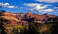
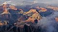
Buddha Temple upper right
-
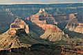
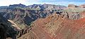
Isis Temple left, Cheops Pyramid in front, Buddha Temple right of center in back.
-
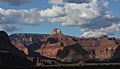
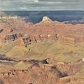
Buddha Temple centered in back
-
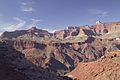
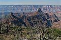
Buddha Temple from Yaki Point
-
Buddha Temple and Manu Temple (left) from Widforss Point
-
Buddha and Manu Temples, east aspect from Komo Point.


.jpg)


.jpg)


Images for kids
-
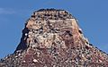
Buddha Temple detail

