
Isis Temple facts for kids
Quick facts for kids Isis Temple |
|
|---|---|
.jpg)
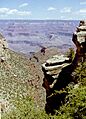
Isis Temple is the landform on the right with the summit block (capstone). (Flat-topped & heavily forested Shiva Temple prominence to left}
|
|
| Highest point | |
| Elevation | 7,006 ft (2,135 m) NGVD 29 |
| Prominence | 1,666 ft (508 m) |
| Geography | |

Isis Temple
Location in Arizona
|
|
| Location | Grand Canyon Coconino County, Arizona. U.S. |
| Topo map | USGS Shiva Temple |
| Geology | |
| Age of rock | Permian down to Proterozoic |
| Type of rock | sedimentary, upon Unkar Group quartzite and sedimentary Coconino Sandstone-(prominence), Hermit Shale, Supai Group, Redwall Limestone, Muav Limestone Temple Butte Formation Tonto Group-(units 2,3 of 3) 3_Muav Limestone, 2_Bright Angel Shale, Unkar Group-(units 1,2,3 of 5) 3_Shinumo Quartzite, 2_Hakatai Shale, 1_Bass Limestone, Vishnu Basement Rocks |
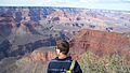
Isis Temple is a cool mountain in the famous Grand Canyon in Arizona, USA. It's a tall, rocky peak that stands out below the North Rim of the canyon. Imagine looking down from the top of the canyon, and there it is!
This amazing landform is located north of the Colorado River, which flows through the Grand Canyon. Two creeks, Trinity Creek and Phantom Creek, flow around its sides. Isis Temple is only about 200 feet lower than Grand Canyon Village, which is a main spot for visitors on the South Rim.
Isis Temple is about 5 miles directly north of Grand Canyon Village. It's part of a larger block of land that has been pushed up by natural forces. This block also includes a smaller peak called Cheops Pyramid, which is about 1,600 feet lower than Isis Temple. The very top of Isis Temple is made of a strong rock called Coconino Sandstone, which resists erosion.
Contents
Exploring Isis Temple: Trails and Views
If you love hiking, there are trails that offer amazing views of Isis Temple.
Hiking Trails Near Isis Temple
- The North Kaibab Trail leads into Bright Angel Canyon. From here, you can see Isis Temple and the flat areas around it, known as Utah Flats.
- One trail even takes you to a viewpoint at the Isis-Cheops Saddle, which is a low point between Isis Temple and Cheops Pyramid.
- From the North Rim, the Tiyo Point Trail gives you great views of Isis Temple from the north side.
Best Spots to See Isis Temple
You can see Isis Temple from several viewpoints on both the South and North Rims of the Grand Canyon.
- From the South Rim, you can see it from Hopi Point and Yavapai Point. Both are near Grand Canyon Village.
- From the North Rim, the Bright Angel Point area offers good views. Isis Temple is about 3 miles south of Tiyo Point and about 5 miles southwest of Bright Angel Point.
The Amazing Geology of Isis Temple

Isis Temple is like a giant history book made of rock. Its layers tell the story of millions of years!
Rock Layers at the Top
The very top of Isis Temple is made of Coconino Sandstone. This rock layer is about 7,000 feet high, similar to the height of the North Rim. Below this sandstone, you'll find the Hermit Shale, which forms slopes, and then the Supai Group 'redbeds'. These red layers are made of different kinds of rock, including the Esplanade Sandstone.
Deeper Rock Formations
Below the red layers, you'll see the strong, cliff-forming Redwall Limestone. Underneath that are more slopes made of Muav Limestone and Bright Angel Shale. These layers sit on top of a very hard rock called Shinumo Quartzite.
The Shinumo Quartzite forms the base of the main cliffs of Isis Temple. Below it, you can see colorful layers of yellow, red, and purple from the Hakatai Shale and the Bass Formation. These lowest layers sit on top of the Vishnu Basement Rocks, which are some of the oldest rocks in the Grand Canyon.
How Isis Temple Was Formed
Isis Temple and Cheops Pyramid are part of a special block of land that was pushed up by forces deep within the Earth. This block also has smaller cracks, called faults, running through it. The rocks in this area, especially the Unkar Group at the base of Isis Temple, are tilted about 15 degrees. This tilt shows how much the Earth has moved and changed over time!
Nearby Landforms in Trinity Canyon
Trinity Canyon is home to several other interesting landforms near Isis Temple:
- Shiva Temple (Grand Canyon) is to the north.
- Claude Birdseye Point is on the western side.
- Further south, you'll find a series of peaks that get lower in height:
- Osiris Temple (about 6,613 feet tall)
- Horus Temple (about 6,150 feet tall)
- Tower of Set (about 6,012 feet tall)
These peaks are all near where Trinity Creek flows into the Colorado River.
Images for kids
-
View from the southwest, about 5.5 miles away. You can see Isis Temple and Buddha Temple, separated by Phantom Creek. Shiva Temple is on the left.
-
Isis Temple and Cheops Pyramid, seen from the South Rim area.


