
Cheops Pyramid facts for kids
Quick facts for kids Cheops Pyramid |
|
|---|---|

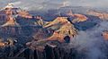
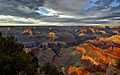
South aspect, from South Rim's Yavapai Point
|
|
| Highest point | |
| Elevation | 5,401 ft (1,646 m) |
| Prominence | 800 ft (240 m) |
| Isolation | 1.72 mi (2.77 km) |
| Parent peak | Isis Temple (7,006 ft) |
| Geography | |

Cheops Pyramid
Location in Arizona

Cheops Pyramid
Location in the United States
|
|
| Location | Grand Canyon National Park Coconino County, Arizona, US |
| Parent range | Kaibab Plateau Colorado Plateau |
| Topo map | USGS Phantom Ranch |
| Type of rock | sandstone, limestone, shale |
| Climbing | |
| Easiest route | class 4 climbing |
Cheops Pyramid is a cool mountain peak in the amazing Grand Canyon, Arizona, USA. It stands tall at 5,401 feet (1,646 meters) above sea level. This special type of mountain, called a butte, looks like a flat-topped hill with steep sides.
It's located in Coconino County, about four miles north of Grand Canyon Village. Cheops Pyramid is also near other famous peaks. It's about 2.5 miles southwest of Buddha Temple and 1.7 miles southeast of Isis Temple.
This butte rises dramatically, about 3,000 feet (914 meters) above the Colorado River in just 1.5 miles. That's a huge drop! The area around Cheops Pyramid has a Cold semi-arid climate. This means it's usually dry with hot summers and cold winters.
How Cheops Pyramid Got Its Name
The name "Cheops Pyramid" was given by George Wharton James. He thought the mountain looked a lot like the famous Great Pyramid of Giza in Egypt. That pyramid was built by an ancient Egyptian pharaoh named Khufu, also known as Cheops.
This naming tradition was started by Clarence Dutton. He liked to name Grand Canyon features after gods and goddesses from old myths. The name "Cheops Pyramid" was officially accepted in 1906. This was done by the United States Board on Geographic Names.
What is Cheops Pyramid Made Of?
Cheops Pyramid is a natural leftover from erosion. Imagine water and wind slowly wearing away rock over millions of years. This mountain is what's left behind.
It has a flat top made of a rock called Redwall Limestone. This limestone formed during the Mississippian period, a long time ago. Below the limestone, you'll find green shale slopes. These shales are part of the Tonto Group from the Cambrian period. Even deeper, there are red shales and a tough rock called Shinumo Quartzite. These older rocks belong to the Unkar Group from the Proterozoic era.
When it rains on Cheops Pyramid, the water flows off its sides. This water, called runoff, drains south towards the Colorado River. It travels through two creeks: Phantom Creek on the east side and Ninetyone Mile Creek on the west side.
Images for kids
-
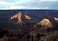
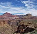
Isis Temple left, Cheops Pyramid in front, Buddha Temple right of center in back.
-
Isis Temple left, Cheops Pyramid right
-
Cheops Pyramid (left) and Buddha Temple (right), seen from junction of the Tonto West Trail and Bright Angel Trail
-
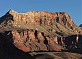
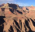
Southeast aspect from Bright Angel Trail
-
Isis Temple left, Cheops Pyramid right
-
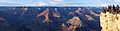
Cheops Pyramid in bullseye, from Hopi Point
-
Cheops Pyramid below onlookers at Maricopa Point
-
Cheops Pyramid (left) and Buddha Temple (right)


