Maplesville, Alabama facts for kids
Quick facts for kids
Maplesville, Alabama
|
|
|---|---|
 |
|

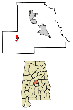
Location of Maplesville in Chilton County, Alabama.
|
|
| Country | United States |
| State | Alabama |
| County | Chilton |
| Area | |
| • Total | 3.48 sq mi (9.00 km2) |
| • Land | 3.43 sq mi (8.89 km2) |
| • Water | 0.04 sq mi (0.11 km2) |
| Elevation | 351 ft (107 m) |
| Population
(2020)
|
|
| • Total | 637 |
| • Density | 185.50/sq mi (71.63/km2) |
| Time zone | UTC-6 (Central (CST)) |
| • Summer (DST) | UTC-5 (CDT) |
| ZIP code |
36750
|
| Area code(s) | 334 |
| FIPS code | 01-46504 |
| GNIS feature ID | 0160032 |
Maplesville is a small town in Chilton County, Alabama, United States. In 2020, about 637 people lived there. It's located almost exactly halfway between the cities of Tuscaloosa and Montgomery. You can find it right on U.S. Route 82.
Contents
A Look at Maplesville's History
The town of Maplesville didn't always sit where it is today. It first started about 3 miles (5 km) east of its current spot, close to Mulberry Creek.
How Maplesville Began
European settlers moved to this area from Georgia and the Carolinas. This happened after a big battle called the Battle of Horseshoe Bend in 1814. The town was named after Stephen W. Maples. He was a merchant and also the first person to run the post office there.
A Busy Crossroads Town
The first Maplesville was a very important place. It was where two major trading roads met. One road went from Selma to Birmingham. The other went from Tuscaloosa to Montgomery. By 1850, the original town had 809 people. It even had two horse-racing tracks that brought many visitors. There were also inns and taverns for travelers using the stagecoaches.
Moving the Town to the Railroad
In the early 1850s, the original town started to shrink. This was because two new railway lines were built about 3 miles (5 km) west of the town. The Alabama & Tennessee River Railway was finished in 1853. A train station, called a depot, was built there too.
People and businesses from the old Maplesville began to move closer to the railroad. When the Maplesville Post Office moved to the new railroad town in 1856, the new place was officially named Maplesville. The old town slowly became empty. Today, all that's left is the Old Maplesville Cemetery along Highway 191. This cemetery holds the graves of many of the town's first residents. It also has the oldest grave in Chilton County, from 1833.
Railroads and Growth
Because Maplesville had good access to trains, it became a key place for shipping cotton and other goods. In 1865, during the Civil War, the train depot was destroyed by Union general James H. Wilson and his soldiers. It was rebuilt after the war but burned down in 1911.
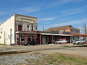
Maplesville continued to grow when the Mobile and Ohio Railroad built a line through town in 1897. Many of the old buildings you see today were built around that time. In 1901, a lumber mill opened nearby. More people moved to Maplesville to work at the mill, and the town's population grew.
Maplesville officially became a town in 1914. It reincorporated in 1947. By 1951, the town had a telephone system, garbage collection, and a water system. A new town hall was built in 1975.
Historic Places to See
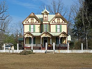
Maplesville has four important historic sites. The Walker-Klinner Farm is listed on the National Register of Historic Places. Three other places are listed on the Alabama Register of Landmarks and Heritage:
- Maplesville Depot (built around 1912)
- Maplesville Methodist Episcopal Church (built between 1870 and 1890)
- Maplesville Railroad Historic District (from the 19th and 20th centuries)
Maplesville's Geography
Maplesville is located in the southwestern part of Chilton County. It sits along U.S. Route 82. This highway goes northwest towards Tuscaloosa (about 55 miles or 89 km away) and southeast towards Montgomery (about 49 miles or 79 km away). Alabama State Route 22 also runs through the town. It goes east to Clanton, which is the county seat, and southwest to Selma.
The town covers a total area of about 3.3 square miles (8.6 km2). Most of this, about 3.3 square miles (8.5 km2), is land. A small part, about 0.04 square miles (0.1 km2), is water.
Population Information
| Historical population | |||
|---|---|---|---|
| Census | Pop. | %± | |
| 1920 | 376 | — | |
| 1930 | 456 | 21.3% | |
| 1950 | 806 | — | |
| 1960 | 679 | −15.8% | |
| 1970 | 596 | −12.2% | |
| 1980 | 754 | 26.5% | |
| 1990 | 725 | −3.8% | |
| 2000 | 672 | −7.3% | |
| 2010 | 708 | 5.4% | |
| 2020 | 637 | −10.0% | |
| U.S. Decennial Census 2013 Estimate |
|||
2020 Census Details
The 2020 United States census counted 637 people living in Maplesville. There were 246 households and 163 families.
| Race | Num. | Perc. |
|---|---|---|
| White (non-Hispanic) | 439 | 68.92% |
| Black or African American (non-Hispanic) | 154 | 24.18% |
| Native American | 4 | 0.63% |
| Other/Mixed | 28 | 4.4% |
| Hispanic or Latino | 12 | 1.88% |
Fun Things to Do in Maplesville
Attractions
- Minooka Park
- Many beautiful walking trails
Places of Worship
- Maplesville Baptist Church
- Maplesville United Methodist Church
- Pilgrim Rest Baptist Church
- Happy Church, Inc./Christian Life Church Learning Center
Historic Cemeteries
- Goodwin Family Cemetery
- Atchison Family Cemetery
- Abney Family Cemetery
- Old Maplesville Cemetery
Historic Buildings
- Walker-Klinner Farm
- Maplesville Depot
- Maplesville Methodist Church
- Maplesville Railroad Historic District
- Ebenezer Baptist Church
Famous People from Maplesville
- Tommie Agee, a former football player for Auburn and the NFL
- Randall Atcheson, a classical pianist
- Harold Morrow, a former football fullback for Auburn and the NFL
- Nathaniel Watson, a former football player for Mississippi State and a future NFL player. He was named the 2023 AP SEC Defensive Player of the Year.
Images for kids
See also
 In Spanish: Maplesville para niños
 | Delilah Pierce |
 | Gordon Parks |
 | Augusta Savage |
 | Charles Ethan Porter |


