Marble Mountain (Alaska) facts for kids
Quick facts for kids Marble Mountain |
|
|---|---|

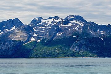
Marble Mountain, northeast aspect
|
|
| Highest point | |
| Elevation | 3,366 ft (1,026 m) |
| Prominence | 566 ft (173 m) |
| Isolation | 1.08 mi (1.74 km) |
| Parent peak | Peak 3390 |
| Geography | |
| Location | Glacier Bay National Park Hoonah-Angoon Alaska, United States |
| Parent range | Fairweather Range Saint Elias Mountains |
| Topo map | USGS Mount Fairweather C-1 |
Marble Mountain is a mountain in southeast Alaska. It stands 3,366 feet (1,026 meters) tall. This peak is part of the Fairweather Range within the larger Saint Elias Mountains. You can find it inside Glacier Bay National Park and Preserve.
The mountain is located at the entrance to Geikie Inlet. It is about 68 miles (109 kilometers) west-northwest of Juneau. It is also about 10.7 miles (17.2 kilometers) east-northeast of Blackthorn Peak. Even though it's not super high, Marble Mountain looks very tall. This is because it rises straight up from the water in Shag Cove in less than one mile. The name "Marble Mountain" was already used by local people. The United States Geological Survey reported this name in 1951.
Exploring Marble Mountain
You can see Marble Mountain from Glacier Bay. This area is a very popular spot for cruise ships. The best time to visit and see Marble Mountain is from May through June. During these months, the weather is usually the nicest.
Understanding the Climate
Marble Mountain has a subpolar oceanic climate. This means it has long, cold, and wet winters. The summers are cool. Temperatures can drop below −20 °C (or −4 °F). With wind chill, it can feel even colder, below −30 °C (or −22 °F). All the rain and melted snow from the mountain flow into Glacier Bay Basin.
 | Delilah Pierce |
 | Gordon Parks |
 | Augusta Savage |
 | Charles Ethan Porter |


