
Maresfield facts for kids
Quick facts for kids Maresfield |
|
|---|---|
 |
|

Maresfield
|
|
| Area | 26.3 km2 (10.2 sq mi) |
| Population | 3,656 (Parish-2011) |
| • Density | 320/sq mi (120/km2) |
| OS grid reference | TQ466240 |
| • London | 36 miles (58 km) NNW |
| Civil parish |
|
| District |
|
| Shire county | |
| Region | |
| Country | England |
| Sovereign state | United Kingdom |
| Post town | UCKFIELD |
| Postcode district | TN22 |
| Dialling code | 01825 |
| Police | Sussex |
| Fire | East Sussex |
| Ambulance | South East Coast |
| EU Parliament | South East England |
| UK Parliament |
|
| Website | http://www.maresfieldparish.org.uk/ |
Maresfield is a village and civil parish in East Sussex, England. It is part of the Wealden District. The village is about 1.5 miles (2.4 km) north of Uckfield.
Other nearby villages like Nutley and Fairwarp, along with smaller places like Duddleswell and Horney Common, are also part of Maresfield parish. Some areas of Ashdown Forest are within the parish too.
Contents
History of Maresfield
The name Maresfield might come from an old English word mere, meaning 'pool'. The second part, feld, definitely means 'open land'.
Iron making was very important here long ago. This was when the Wealden iron industry was very busy. In the 1500s, there were five iron furnaces near Maresfield Church. These included Oldlands, Hendall, and Maresfield (which made gunpowder).
Families like the Levetts, Popes, and Chaloners lived in the area for a long time. They were connected to the iron industry. William Levett, a vicar, helped start the iron industry in the Weald. He supplied weapons to King Henry VIII.
Later, Ralph Hogge, who used to work for Levett, became a major iron producer. He ran four furnaces and at least one forge close to Maresfield Church.
Village Growth Over Time
Maresfield is an old village. Its church was first built around the year 1100. The main part of the church and its tower were built between 1375 and 1415.
Fairwarp and Nutley grew from Maresfield. There was a Roman settlement here, where they made iron. Later, a Norman village grew around the church.
The Manor and Estates
Until 1926, Maresfield was mostly a farming village. Before 1914, the village was largely owned and controlled by the family living in Maresfield Park House. First, it was the Shelley family, then Count Alexander Münster from Germany.
During World War I, the government took control of the estate in 1914. The Park and its houses were sold in 1924 to help pay for war damage. The Park itself was divided into plots for houses.
A large army camp was built here during World War I. Later, parts of the village, like Queen's Drive, became homes for soldiers' families. Another big army camp was set up west of the village during World War II. This land is now used for houses and the Ashdown Business Park.
Recent Development
Maresfield has grown a lot recently. Since about 1990, new housing areas have been built. These include Mulberry Park, The Paddock, Field End, Maple Close, and Forest Park. These new homes have increased the village's population by about one-third. More homes are planned, which will make the village even bigger.
How Maresfield is Governed
Maresfield has a Parish Council with 14 members. Their offices are located in Nutley. The Parish Council helps manage local services and issues for the community.
Geography of Maresfield
Maresfield is located on the southern edge of Ashdown Forest. This forest was once a place where kings, like King Edward II, hunted deer.
Rock Wood, a special woodland area, is also in the parish. It is important for its biology, with rare mosses and ferns growing by the stream. This area is a Site of Special Scientific Interest.
Nutley Village
Nutley is a village north of Maresfield, located on the main A22 road. It has its own church, St James the Less. However, the church works together with the Maresfield church.
Fairwarp Village
Fairwarp is a small village directly north of Maresfield. Its church is called Christ Church.
Transport Links
The parish is where two main roads meet. These are the A22 Eastbourne road and the A272 cross-country road. The main road now goes around the west side of the village to avoid traffic.
Two local bus services, 31 and 256, connect Maresfield to nearby areas.
Sports and Leisure Activities
Maresfield has several sports clubs close to the Chequers Inn. These include a tennis club, a cricket club, a football club, and a gymnastics club.
The bowls club has recently closed. The cricket club mainly plays friendly matches now. Maresfield is also home to Underhill Fishing Lake, which is managed by a local anglers' association.
Education in Maresfield
Maresfield has its own primary school, Bonners CE Primary School. Some children from Maresfield also go to Manor Primary School in Uckfield. For secondary school, students usually travel to Uckfield College or Chailey School.
Conservation Efforts
The Maresfield Conservation Group is a charity that works to protect and improve the local environment. They are involved in many projects to help conserve the natural beauty of Maresfield and its surroundings. You can find more information on their website.
Village Amenities
In the center of Maresfield, you'll find the Chequers Inn. This historic building from the 1600s is a Grade II* listed building. The Maresfield church, founded around 1100, is also in the village center.
The Maresfield recreation ground is a popular spot. It is home to the Maresfield Cricket Club, which started in 1756.
The recreation ground was given to the Maresfield Parish Council in 1897. This gift was to celebrate Queen Victoria's Golden Jubilee. The Empress Frederick, Queen Victoria's oldest daughter, planted a special oak tree there. The land was officially transferred in 1899.
Freedom of the Parish
The "Freedom of the Parish" is an honor given to people or military groups.
Military Units Honored
- 5 (Maresfield) Squadron 11 (Royal School of Signals) Signal Regiment: They received this honor on June 27, 2021.
Gallery
-
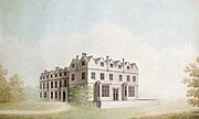
Maresfield Park, a painting by Benjamin Dean Wyatt
-
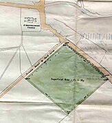
A map showing the Maresfield Recreation Ground
-
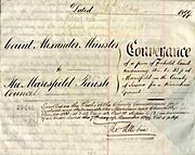
The official document that transferred the recreation ground to the Parish Council
-
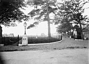
The entrance to the recreation ground in 1897
-
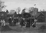
The Empress Frederick planting a special oak tree in 1897
-
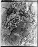
An aerial view of the Maresfield army camp from 1947


See also
In Spanish: Maresfield para niños
