Margerie Glacier facts for kids
Quick facts for kids Margerie Glacier |
|
|---|---|

Margerie Glacier
|
|
| Type | Tidewater — constrained valley |
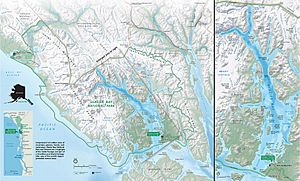
| Location | Glacier Bay National Park Mount Root to Glacier Bay, Alaska |
| Coordinates | 58°58′04″N 137°10′33″W / 58.96778°N 137.17583°W |
| Length | 21 miles (34 km) |
| Thickness | 350 feet (110 m) |
| Terminus | Sea level |
| Status | Stable |
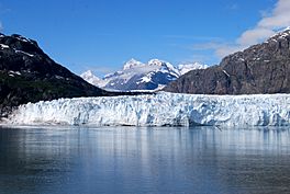
The Margerie Glacier is a huge river of ice, about 21 mi (34 km) long. It's located in Glacier Bay, Alaska, United States. This amazing glacier is part of the Glacier Bay National Park and Preserve.
The glacier starts high up on the southern side of Mount Root. This mountain is about 12,860 feet (3,920 m) tall and sits on the border between Alaska and Canada. From there, the Margerie Glacier flows down a valley. It ends in a place called Tarr Inlet, where it meets the sea.
Margerie Glacier is one of the most popular glaciers to visit in Glacier Bay. It's also very active, meaning you can often see ice breaking off. While many glaciers in the park are shrinking, Margerie Glacier is special because it's staying about the same size. It's not growing or getting smaller.
This glacier is about 1 mile (1.6 km) wide. Its end, where it meets the water, is about 350 feet (110 m) tall. About 100 feet (30 m) of this height is actually hidden underwater!
Back in 1750, Glacier Bay was almost completely covered by one giant glacier. But over many years, the weather got warmer and there was less snowfall. This caused the ice to melt, creating the 65 miles (105 km) long fjord we see today. A fjord is a long, narrow inlet of the sea between high cliffs. Margerie Glacier is found at the far northwestern end of this bay.
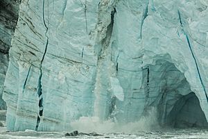
You can only reach Glacier Bay and its glaciers by plane or boat. There are no roads leading into the park. Because the Margerie Glacier drops steeply into the water, cruise ships and tour boats can get very close. This gives visitors an amazing view of ice calving, which is when large chunks of ice break off and fall into the sea.
Contents
History of Margerie Glacier
Margerie Glacier got its name from a French scientist named Emmanuel de Margerie. He was a geologist and geographer who visited this area in 1913.
In 1794, a sea captain named George Vancouver explored Glacier Bay. He found the bay completely blocked by a massive wall of ice. This ice wall was 20 miles (32 km) wide and 4,000 feet (1,200 m) high!
When a famous naturalist named John Muir first saw the bay in 1879, the ice had already melted back about 48 miles (77 km). Today, the ice wall has moved back even further, about 65 miles (105 km) from the mouth of the bay. It's just a small part of the huge glacier Captain Vancouver saw. Now, Glacier Bay has eight tidewater glaciers, including Margerie, located in smaller inlets.
The glaciers in Glacier Bay are leftovers from a period called the Little Ice Age. This cooler time began about 4,000 years ago. Around 1750, the Little Ice Age ended, and the glaciers started to melt back.
Margerie Glacier has moved at different speeds. It was once recorded moving about 2,000 feet (610 m) per year, or 6 feet (1.8 m) each day! Later, its movement slowed down to about 30 feet (9.1 m) per year. By 1998, parts of the glacier started to shrink a little. In the 1990s, Margerie Glacier was connected to another large glacier called the Grand Pacific Glacier. But now, Margerie has separated from it.
Amazing Features of Margerie Glacier
Margerie Glacier is a type of glacier called a tidewater glacier. This means its end touches the seawater, at least when the tide is high. Margerie Glacier and six other glaciers in the park are fully underwater at their ends, no matter the tide.
The glacier's total height is 350 feet (110 m). About 250 feet (76 m) of it rises above the water. The other 100 feet (30 m) is below the surface. Like many glaciers, Margerie has dark areas called moraines. These are made of dirt, stones, and rocks mixed into the ice. They are carried along by the glacier and eventually dropped at its end.
Glacial ice often looks blue. This happens because the ice absorbs colors like red, orange, yellow, and green from sunlight. Only the blue light is reflected, making the ice appear blue. So, any pools of melted water on top of the glacier will also look bright blue.
Margerie Glacier is quite clean, with less dirt and rocks compared to the Grand Pacific Glacier next to it. It's also one of the best places to see ice calving. When a glacier calves, you might hear sounds like gunshots as the ice cracks. Then, a loud boom happens as the ice falls into the sea. This is also when trapped air inside the ice is released.
Freshwater flows out from under the center of the glacier where it meets the sea. This happens because meltwater streams run beneath the ice. These areas attract seabirds, which come to feed on the fish found there.
Scientists have also found that Margerie Glacier contains deposits of copper.
Animals and Plants Near Margerie Glacier
Margerie Glacier is part of the larger Glacier Bay National Park and Preserve. This park has many different environments, like tidewater glaciers, coastlines, fjords, rivers, and lakes. These different areas are home to a wide variety of living things.
The park has 333 types of plants with veins (like trees and flowers). It also has 274 different kinds of birds, 160 types of fish, 41 mammal species, and 3 types of amphibians.
You can find Arctic terns and gulls nesting in the rocks around Margerie Glacier. When the glacier calves, it stirs up tiny sea creatures called krill and small fish. This makes it a great feeding spot for birds. Sometimes, you might even spot Humpback whales and grizzly bears near the glacier.
Scientists have also studied something unique on Margerie Glacier called "glacier mice." These are colonies of mosses that form small, round balls. They slowly move across the glacier over time, but exactly how they move is still a bit of a mystery!
See also
 In Spanish: Glaciar Margerie para niños
 | Misty Copeland |
 | Raven Wilkinson |
 | Debra Austin |
 | Aesha Ash |


