Maritime trade in the Maya civilization facts for kids
The Ancient Maya were amazing traders! Their huge trade networks helped their civilization last for over 3,000 years. Maya kings and queens controlled the trade of goods. They made sure people had what they needed and that important items reached the wealthy.
Trade from the Caribbean and Gulf Coasts was super important. It brought resources to big inland Maya cities. This helped thousands of people live there. The ruling class mostly controlled trade. But a middle class of merchants managed goods coming in and out of cities. We don't know much about these merchants. But sometimes, pictures show royal merchants with canoe paddles. This shows their connection to water trade.
Water lilies are also seen in Maya art, even in cities far from water. This shows how important water connections were. Maya canoes and other small boats appear in ancient books called codices. They sometimes carried kings or gods. Even today, people use coastal areas for resources. Over time, relying on sea trade shifted power to coastal cities. Places like Uxmal and Chichen Itza became very important. Sea trade continued to be key until Europeans arrived.
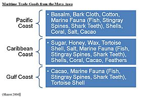
Everyday Coastal Trade Goods
One of the biggest coastal industries was salt mining. Salt is a basic need for everyone. It was hard to get in the inland areas of Central America. So, salt workshops popped up along the Maya coast. They used a method called sal cocida, boiling salty water in clay pots.
These workshops, like those in Belize, provided salt for eating. They also used salt to preserve fish. This fish was then traded from the coast to inland cities. Salt was important for both common people and the wealthy. But the best "white" salt from the Yucatán coast was likely for the elite.
Basic household items were also traded. These included food like corn, beans, fish, and honey. Stone tools, grinding stones, textiles, and simple pottery also moved between trade sites.
Special Coastal Trade Goods
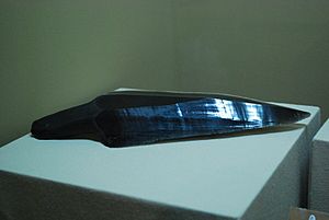
Trading fancy goods showed how complex the Maya economy was. Controlling these special items helped kings keep their power. Items like obsidian, seashells, stingray spines, and fine pottery were only for the rich. Jadeite, cacao, quetzal feathers, and gold were also very rare.
Finding these items in both inland and coastal sites shows connections to important people. It also shows links to big city centers. Not all coastal sites were just towns. Some were mainly trade ports because they were in good spots, like at river mouths.
Moho Cay in southern Belize was one such port. High-quality chert and obsidian from Guatemala were gathered there. They were then sent down the Belize River to big cities like Tikal. Wild Cane Cay also traded foreign obsidian. Seashells, especially conch and spondylus, were valued for rituals and jewelry. Scientists can now tell where shells came from using special tests. Stingray spines from the coast were used in royal rituals. Kings would use them to draw blood and talk to ancestors or gods.
Gold and jade were rare in the Maya area. Much of it came from far away, like Costa Rica and Ecuador. These goods likely traveled along Caribbean sea routes. Inland routes were often too hard to cross. Maya items have also been found in those distant regions.
Maya Ports
Many port sites have been found across the Maya world. Ports fit into four main types. These include places where goods were transferred, independent ports, ports controlled by inland cities, and departure ports.
Cerros
Cerros is in Chetumal Bay, at the mouth of the New River. It is the oldest known Maya port, dating back to the Early Classic period. Cerros was a big settlement with large buildings and homes. It also had a stone dock and man-made canals. Cerros was most important in the Late Classic period. It became a key port again in the Postclassic period. It was abandoned around 400 CE.
Chac Balam
Chac Balam is on the north side of Ambergris Caye, Belize. It has a man-made harbor over 100 meters wide. The site is built around a plaza with structures on raised platforms. Items found here show long-distance trade. These include obsidian, basalt, slate, jade, and pottery. Burials found here include one of a man with jade items. This suggests he was an elite, maybe even a ruler.
Chac Mool
Chac Mool is in Cancún, on the Caribbean coast of Yucatan. It was used for transferring goods and making salt. Items found here are linked to Chichen Itza. The site was active from the Terminal Classic to the Postclassic period.
El Meco
El Meco is on the eastern side of the Yucatán Peninsula. It is across from Isla Mujeres. The site was used throughout the Classic and Postclassic periods. It became an important port with links to Chichen Itzá and Mayapán. It might have controlled access to Isla Mujeres.
Isla Cerritos
Isla Cerritos is on the north coast of Yucatán, in the Gulf of Mexico. It was a major port for the inland city of Chichen Itza. It kept working for about 200 years after Chichen Itza declined. The island has many docking areas. The south side has a 300-meter seawall with three entrances. One entrance was likely the main one and may have had towers. Isla Cerritos was used from the Late Preclassic to the Early Postclassic.
Isla de Piedras
Isla de Piedras is on the Gulf Coast of the Yucatán peninsula, near Jaina. The island has clear port features. It was most active in the Classic period. It is thought to be an independent port. Some think it might have formed a coastal trading group with Jaina.
Jaina
Jaina is also on the Gulf Coast of the Yucatán peninsula, near Isla de Piedras. The Maya made part of the island bigger. It is seen as an independent port. Some believe it may have formed a coastal trading group with Isla de Piedras.
Laguna Francos
Laguna Francos is about halfway down Ambergris Caye, Belize. It is a large site for the island. It has a natural harbor and organized mounds. These mounds supported buildings made of poles and thatch. Small plazas were located between the mounds. Many items found here show long-distance trade. These include unique pottery, obsidian, basalt, and greenstone.
Marco Gonzalez
Marco Gonzalez is on the southern side of Ambergris Caye, Belize. It is probably the largest site on the island. It covers a big area and has at least 53 buildings. It was a major port for the inland city of Lamanai. Unlike other sites on the Caye, it grew after the Terminal Classic period. This matches Lamanai, which survived the 'Maya Collapse'. Marco Gonzalez was used until at least the 13th century. Items found include obsidian from Mexico and Guatemala, unique pottery, and greenstone.
Moho Cay
Moho Cay is in southern Belize, at the mouth of the Belize River. It was a port for transferring goods. It had two main periods of use: between 400 and 700 CE, and a smaller one between 900 and 1100 CE. Only the north side of the island was used. The rest was mangrove swamp. The site was destroyed in 1980 during dredging for a modern marina.
San Gervasio
San Gervasio is on Cozumel island, off the Caribbean coast of Yucatan. The island has many structures that may have helped with navigation. Stone roads linked the sea to the settlement. Some think merchants from Cozumel founded Mayapán after Chichen Itzá fell. San Gervasio was especially linked to cotton and honey trade. It also traded obsidian, pottery, and greenstone. Cozumel was one of the first Maya places taken by the Spanish. Most of its people died from violence and disease.
San Juan
San Juan is on the northern side of Ambergris Caye, Belize. It was the first place a canoe would reach after passing through the Bacalar Chico canal. The site is small and has no large plaza. But it is next to a natural harbor. It has buildings typical of other port sites, including round storage areas. Construction started around 600 CE. The site was used until about 1000 AD. San Juan has more green obsidian from Central Mexico than other sites in the area. It also has a lot of grey obsidian from Guatemala, pottery, and jade. This shows it was a transfer port. Many burials have been found here. They give clues about the health of the coastal Maya.
Santa Rita
Santa Rita is across from Ambergris Caye on the mainland. It is between the New River and Rio Hondo. The site is linked to Tikal and was active during the Classic period.
Tulum-Tancah
Tulum and Tancah are next to each other on the eastern side of the Yucatán peninsula. They face the Western Caribbean Sea. Spanish explorers in the 1500s said Tulum was bigger than Seville. The sites were first built in the Preclassic period. They grew and became key sites in the Postclassic. Tulum is famous for its Castillo. This building may have worked like a lighthouse. It showed where the gap in the coral reef was. The site also had defenses on its land side.
Uaymil
Uaymil is near the ports of Jaina and Isla Piedras on the Gulf Coast of Yucatan. The site is linked to the inland cities of Uxmal and Chichen Itzá. It was a transfer point for goods that would eventually go to Chichen Itzá via Isla Cerritos.
Vista Alegre
Vista Alegre is on the north of the Yucatán peninsula, on the Laguna Holbox. The port was a departure point for local pottery. It also transferred goods. The site has a raised road that goes into the water on both sides. This was probably used for docking boats.
Wild Cane Cay
Wild Cane Cay is at the southern end of Belize. It is inside the Mesoamerican Barrier Reef. It is also near the mouth of the Deep River. The site was important from the Classic to the Postclassic period. It was a key transfer port for obsidian. It brought obsidian from the highlands of Guatemala to inland Maya sites.
Xcambó
Xcambó is on the northern coast of Yucatan. It was first used in the Early Classic and abandoned around 700 CE. The port was independent and also produced salt. It was built on a mound in marshland. It was expanded with platforms linked by raised roads. These also connected to a temple and to the sea.
Xcaret
Xcaret is on the mainland, across from the island of Cozumel. Ancient Maya books mention it as a key port where Maya canoes stopped.
Xelhá
Xelhá is just up the coast from Tancah-Tulum. It was first used in the Early Classic and continuously occupied until the 16th century. The site has a natural harbor and port features. These include defenses and a raised road. It was an independent port that transferred goods. It had key links to the jade and obsidian trades.
Maya Boats
The Maya area, like other parts of Mesoamerica, did not have animals to carry goods. Also, the mountains and jungles made using wheels for transport very hard. Instead, people carried goods. Or, if possible, goods were sent by rivers and the sea. Water transport was easier and faster for moving large amounts of goods. This is why the Maya relied on water trade. The Maya mainly used canoes to move their items. Rafts were also used.
Canoes
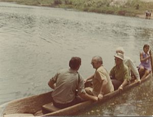
Maya canoes were dugout boats. They were made from a single tree trunk. Cedar might have been used, as it is today. We don't know how they hollowed out the trunk. But in other places, they used controlled burning. The Aztecs added planks to the sides of their canoes. This allowed them to carry more cargo and prevented sinking. The Maya were likely able to do this too.
There seem to have been two types of Maya canoes. One was for the sea, with a raised front and back. This is seen in a mural at Chichen Itza. The other type had a flat platform at the front and back, as shown in models. The canoes were probably made waterproof with pitch, like asphalt.
Only one ancient Maya canoe has been found. It was discovered in Paynes Creek National Park in southern Belize. It dates to the Early Classic period, between 300 and 600 CE. It is still buried because it is hard to preserve. A Maya canoe paddle was also found at a salt works in Paynes Creek. It is 1.43 meters long with an oval blade. It dates to the Late Classic, between 680 and 880 CE. Wood doesn't preserve well in tropical areas. This is why we don't have many ancient Maya canoes.
However, there are many pictures of Maya canoes. And old writings describe them. Murals and items from Tikal and Chichen Itza show Maya canoes. Many model canoes have been found. These include ones from Moho Cay and Altun Ha. Pictures show canoes holding few people, usually up to 7. But old writings say they were very large.
Ferdinand Columbus wrote about seeing a Maya canoe in 1506. It was "as long as a galley and eight feet wide." It was full of goods from the west, likely Yucatán. It had a shelter of palm mats for women, children, and goods. He said there were up to 25 men in the canoe.
Other people who saw them also said Maya canoes were big. Conquistador Bernal Diaz del Castillo said they could hold 40-50 people. Juan Diaz said he saw over 100 canoes with about 3,000 men. This means about 30 men per canoe.
Rafts
The Maya also used rafts, or balsas. Ancient Maya books and a gold disc from Chichen Itza show them. Rafts were also used in other parts of Mesoamerica. This goes back to Olmec times. Old writings suggest rafts were floated using netted gourds under a platform. The navigator and cargo would sit on this platform. No ancient Maya rafts have been found yet.
The Maya mainly used paddles to move their canoes. Pictures, archaeological finds, and old writings confirm this. But some old writings also say the Maya used sails. Historian J. Eric S. Thompson believes the Maya used sails. He points to eyewitness accounts of sails on large Maya canoes.
|
 | Claudette Colvin |
 | Myrlie Evers-Williams |
 | Alberta Odell Jones |


