
Maryhill, Washington facts for kids
Quick facts for kids
Maryhill, Washington
|
|
|---|---|

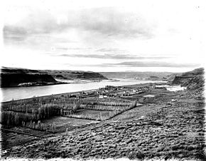
Maryhill from the Stonehenge replica
|
|

Location of Maryhill in Klickitat County, Washington
|
|
| Country | United States |
| State | Washington |
| County | Klickitat |
| Area | |
| • Total | 2.8 sq mi (7.3 km2) |
| • Land | 2.8 sq mi (7.3 km2) |
| • Water | 0 sq mi (0.0 km2) |
| Elevation | 187 ft (57 m) |
| Population
(2020)
|
|
| • Total | 55 |
| • Density | 19.51/sq mi (7.53/km2) |
| Time zone | UTC-8 (Pacific (PST)) |
| • Summer (DST) | UTC-7 (PDT) |
| ZIP code |
98620
|
| Area code(s) | 509 |
| FIPS code | 53-43885 |
| GNIS feature ID | 1522785 |
|
Maryhill from the Stonehenge replica location, but in 1913
|
Maryhill is a small community in Klickitat County, Washington, United States. It is known as a census-designated place (CDP). This means it's an area that the government counts for population, but it doesn't have its own local city government. In 2020, 55 people lived in Maryhill.
History of Maryhill
Maryhill got its name from the wife and daughter of a famous person named Sam Hill. He bought land here in the early 1900s. Sam Hill had big plans for this area. Before it was called Maryhill, the place was known as "Columbia" or "Columbus."
In 1909, local officials wanted to name the town "Maryland." This name was suggested by Sam Hill and his team. However, the postal service said no because "Maryland" was already a state name. So, they changed it to "Maryhill" instead.
Sam Hill used his land in Maryhill to build many important things. He created the first paved roads in the Pacific Northwest. He also built the Maryhill Museum of Art. This building was first meant to be a large home for his family.
Another famous structure he built is the Maryhill Stonehenge. This is a monument that looks like the ancient Stonehenge in England. Sam Hill built it to honor the soldiers from Klickitat County who died in World War I. He wanted it to show that modern wars were a waste of human lives. He believed that Stonehenge was a place of sacrifice, and he saw modern war in a similar way.
Sam Hill was a Quaker, a member of a religious group. He hoped to start a Quaker community in eastern Washington. But his plans didn't work out. The town buildings he built later burned down.
Geography of Maryhill
Maryhill is located in the southern part of Klickitat County, Washington. It sits right on the north bank of the Columbia River. The Columbia River is a very large river. Maryhill is about 209 miles (336 km) upstream from where the river meets the ocean at Astoria, Oregon. It's also 103 miles (166 km) upstream from Portland, Oregon.
A major road, U.S. Route 97 (US 97), crosses the Columbia River at Maryhill. It uses the Sam Hill Memorial Bridge. US 97 goes north towards Goldendale and south into Wasco, Oregon. Another road, State Route 14, runs east and west through Maryhill along the Columbia River. It connects Maryhill to places like White Salmon.
The Maryhill community covers about 7.3 square kilometers (2.8 square miles) of land. There is no water within its official boundaries. The area is also home to Maryhill State Park, which is a nice place to visit along the Columbia River.
Population of Maryhill
| Historical population | |||
|---|---|---|---|
| Census | Pop. | %± | |
| 2000 | 98 | — | |
| 2010 | 58 | −40.8% | |
| 2020 | 55 | −5.2% | |
| US Decennial Census 2020 Census |
|||
Maryhill is a small community. In 2000, there were 98 people living there. By 2010, the population had decreased to 58 people. In the most recent count in 2020, 55 people lived in Maryhill.
The people living in Maryhill come from different backgrounds. In 2000, most residents were White. There were also people who identified as African American, Native American, Pacific Islander, and from other races. Some residents were also of Hispanic or Latino heritage.

See also
 In Spanish: Maryhill (Washington) para niños
