
Mauriac, Cantal facts for kids
Quick facts for kids
Mauriac
|
||
|---|---|---|

Notre-Dame-des-Miracles basilica
|
||
|
||

Mauriac
Location in France

Mauriac
Location in Auvergne-Rhône-Alpes
|
||
| Country | France | |
| Region | Auvergne-Rhône-Alpes | |
| Department | Cantal | |
| Arrondissement | Mauriac | |
| Canton | Mauriac | |
| Intercommunality | Pays de Mauriac | |
| Area
1
|
27.61 km2 (10.66 sq mi) | |
| Population
(2014)
|
3,682 | |
| • Density | 133.36/km2 (345.39/sq mi) | |
| Demonym(s) | Mauriacois | |
| Time zone | UTC+01:00 (CET) | |
| • Summer (DST) | UTC+02:00 (CEST) | |
| INSEE/Postal code |
15120 /15200
|
|
| Elevation | 351–760 m (1,152–2,493 ft) (avg. 722 m or 2,369 ft) |
|
| Website | www.mauriac.fr | |
| 1 French Land Register data, which excludes lakes, ponds, glaciers > 1 km2 (0.386 sq mi or 247 acres) and river estuaries. | ||

Mauriac is a small town, also called a commune, in south-central France. It is located in the Auvergne-Rhône-Alpes region. Mauriac is an important town in the Cantal department. It serves as a "subprefecture," which means it's a main administrative center for its area. It is also the main town of its own arrondissement (a type of district).
Contents
History of Mauriac
Mauriac is one of the oldest towns in the Cantal department. It was founded about 2,000 years ago.
The town grew around two important religious buildings. These were the Saint-Pierre de Mauriac monastery and the Notre-Dame-des-Miracles Basilica.
Geography of Mauriac
Mauriac is located in the northwest part of the Cantal department. It is close to the border with the Corrèze department. The town is also near the Dordogne River.
The Auze River flows through Mauriac. The Auze is a smaller river that joins the Dordogne.
Mauriac is in a hilly area. The main part of the town is about 350 to 450 meters (1,150 to 1,480 feet) above sea level. The surrounding areas go up to about 760 meters (2,490 feet). These higher areas are in the foothills of volcanic mountains. The total area of the town is about 27.61 square kilometers (10.66 square miles).
The towns surrounding Mauriac include Le Vigean, Brageac, Escorailles, Ally, Salins, Jaleyrac, Chaussenac, Sourniac, Drugeac, Chalvignac, and Anglards-de-Salers.
 |
 |
Chalvignac | Le Vigean | Le Vigean | |
| Brageac | Le Vigean | |||
| Brageac | Ally | Le Vigean |
Climate in Mauriac
Mauriac has an oceanic climate. This means it has mild summers and no dry season. In the Köppen climate classification, this climate is called Cfb.
Population of Mauriac
The people who live in Mauriac are called Mauriacois in French. Women are called Mauriacoises.
In 2014, Mauriac had a population of 3,682 people. This means there were about 133 people per square kilometer.
How the Population of Mauriac Has Changed
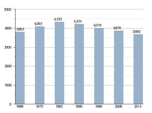
Mauriac and the nearby town of Le Vigean form the urban area of Mauriac. This is one of seven urban areas in Cantal. In 2013, this urban area had 4,559 people and covered about 56.6 square kilometers (21.9 square miles). This urban area is also the center of a larger metropolitan area. This larger area includes five communes with 5,277 people and covers about 93.9 square kilometers (36.3 square miles).
Administration
Mauriac is a subprefecture of the Cantal department. This means it is an important administrative center. It is the main town of the Mauriac arrondissement. It is also the administrative center (called chef-lieu in French) of the Mauriac canton.
Mauriac is part of a group of towns called Pays de Mauriac. This group works together on different projects. In French, this group is known as Communauté de communes du Pays de Mauriac.
Places to Visit
- Notre-Dame-des-Miracles Basilica: This is a very old and beautiful church.
- Saint-Pierre de Mauriac: These are the ruins of an old monastery. It was built in the 12th century.
- Hôtel d'Orcet: This building was built in the 18th century. Today, it is the headquarters for the subprefecture.
Gallery
-
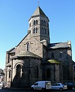
Notre-Dame-des-Miracles basilica.
-

Mauriac from the Val St-Jean lake.
-
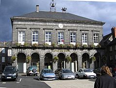
Mauriac town hall.
-
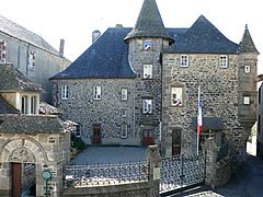
Subprefecture in the former Hôtel d'Orcet


Related pages
Images for kids
-
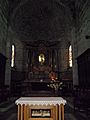
Choir of Notre-Dame-des-Miracles.
-
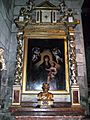
Baroque chapel altar, with reredos showing Virgin and Child, Notre-Dame-des-Miracles.
-
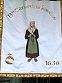
Banner showing the Blessed Catherine Jarrige in Notre-Dame-des-Miracles.
-
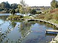
Le lac du Val St Jean, a small reservoir near Mauriac.


See also
 In Spanish: Mauriac (Cantal) para niños
