
Mayfield, New York facts for kids
Quick facts for kids
Mayfield, New York
|
|
|---|---|

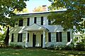
The Oliver Rice House, a historic home museum in Mayfield
|
|

Mayfield, New York
Location in New York
|
|
| Country | United States |
| State | New York |
| County | Fulton |
| Government | |
| • Type | Town Council |
| Area | |
| • Total | 64.68 sq mi (167.53 km2) |
| • Land | 58.38 sq mi (151.22 km2) |
| • Water | 6.30 sq mi (16.31 km2) |
| Elevation | 837 ft (255 m) |
| Population
(2020)
|
|
| • Total | 6,146 |
| • Estimate
(2023)
|
6,094 |
| • Density | 104.39/sq mi (40.30/km2) |
| Time zone | UTC-5 (Eastern (EST)) |
| • Summer (DST) | UTC-4 (EDT) |
| ZIP code |
12117
|
| Area code(s) | 518 |
| FIPS code | 36-035-46217 |
| GNIS feature ID | 979206 |
Mayfield is a town in Fulton County, New York, United States. It is located northeast of the cities of Gloversville and Johnstown. Inside the town of Mayfield, there is also a smaller area called Mayfield village.
In 2010, the town of Mayfield had a population of 6,495 people. By 2023, the estimated population was about 6,094.
Contents
Exploring Mayfield's Past: A Look at Its History
Early Settlements and Land Grants
The land that makes up Mayfield today was once part of many different land grants. These were large areas of land given out by the government in colonial times. Some of these grants included the Mayfield Patent (from 1770) and the Kingsborough Patent (from 1753).
The first European settlements in this area began in the early 1760s. These settlements were started under the guidance of Sir William Johnson, 1st Baronet. He was a British official who knew the lands of the Mohawk people, part of the Iroquois Confederacy. A grist mill, which grinds grain, was built on Mayfield Creek around 1773.
Revolutionary War and Town Formation
During the American Revolutionary War, the Mayfield area was on a path used by raiding forces. These forces included Sir John Johnson, 2nd Baronet and his Loyalist and Mohawk allies. These attacks caused a lot of damage to the early settlers. To protect them, a fort called the Sacandaga Blockhouse was built in 1779. However, many settlers left the area by the end of the war.
The town of Mayfield was officially created in 1793. It was formed from a part of the town of Caughnawaga. This happened before Fulton County was even formed in 1838. Mayfield was one of the first three towns created in this region. Over the years, parts of Mayfield were used to form other towns. For example, parts were taken to create Wells in 1805 and Perth in 1842. Mayfield reached its current size in 1860.
Economy and the Great Sacandaga Lake
In its early days, Mayfield's economy relied on farming. People also worked in the lumber and leather industries. Limestone was another important resource, with many quarries and kilns (ovens for burning limestone) operating in the 1800s. A railroad, the Fonda, Johnstown and Gloversville Railroad, served the town from 1875 to 1984.
A big change came in 1930 with the creation of the Great Sacandaga Lake. The state bought about six square miles of private land in Mayfield to make this large lake. In 1931, most of the town became part of the Adirondack Park. Since then, tourism has become very important to Mayfield's economy.
The Oliver Rice House, a historic home built in 1790, is located in Mayfield. It was added to the National Register of Historic Places in 1995 and is now a museum.
Mayfield's Natural Surroundings: Geography
Mayfield covers a total area of about 64.68 square miles (167.5 square kilometers). Most of this area, about 58.38 square miles (151.2 square kilometers), is land. The rest, about 6.30 square miles (16.3 square kilometers), is water.
The town is mostly located within the beautiful Adirondack Park. It sits on the southwestern shore of the large Great Sacandaga Lake. New York State Route 30 is a major highway that runs north and south through Mayfield. Other important roads include New York State Route 30A and New York State Route 349.
Who Lives in Mayfield: Demographics
| Historical population | |||
|---|---|---|---|
| Census | Pop. | %± | |
| 1820 | 2,025 | — | |
| 1830 | 2,614 | 29.1% | |
| 1840 | 2,615 | 0.0% | |
| 1850 | 2,429 | −7.1% | |
| 1860 | 2,367 | −2.6% | |
| 1870 | 2,241 | −5.3% | |
| 1880 | 2,231 | −0.4% | |
| 1890 | 2,181 | −2.2% | |
| 1900 | 2,136 | −2.1% | |
| 1910 | 2,065 | −3.3% | |
| 1920 | 1,806 | −12.5% | |
| 1930 | 2,077 | 15.0% | |
| 1940 | 2,734 | 31.6% | |
| 1950 | 3,145 | 15.0% | |
| 1960 | 3,613 | 14.9% | |
| 1970 | 4,522 | 25.2% | |
| 1980 | 5,439 | 20.3% | |
| 1990 | 5,738 | 5.5% | |
| 2000 | 6,427 | 12.0% | |
| 2010 | 6,495 | 1.1% | |
| 2020 | 6,146 | −5.4% | |
| 2023 (est.) | 6,094 | −6.2% | |
| U.S. Decennial Census | |||
According to the 2000 census, there were 6,432 people living in Mayfield. These people lived in 2,535 households, with 1,804 of them being families. The population density was about 110 people per square mile.
Most of the people in Mayfield (about 98%) were White. About 32.7% of households had children under 18 living with them. The average household had 2.53 people. The median age in the town was 39 years old.
Places to Know in Mayfield: Communities and Locations
_in_Mayfield,_Fulton_County,_New_York.jpg)
Inhabited Areas
- Broadalbin – A small part of this village is located within the town of Mayfield.
- Cranberry Creek – A small community in the northeastern part of the town.
- Dennies Hollow – A community north of Mayfield village.
- Mayfield – This is the main village within the town of Mayfield.
- Progress – A community in the southwestern part of town.
- Riceville – A community where Routes NY-30 and NY-30A meet.
- Vail Mills – A community in the southeastern part of Mayfield.
Natural Features
- Bernhardt Mountain – This is the highest point in Mayfield, standing at 2,293 feet above sea level.
- Great Sacandaga Lake – A large lake that borders the town.
- Jackson Summit Reservoir – A reservoir located in the northwestern part of the town.
- Mayfield Creek – A stream that flows into Mayfield Lake.
- Mayfield Lake – A small lake south of Mayfield village that connects to Great Sacandaga Lake.
- Scout Island – An island located in the southwestern part of Great Sacandaga Lake.
Images for kids
-
The Oliver Rice House, a historic home museum in Mayfield
-
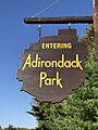
Sign along northbound NY 30 in Mayfield entering Adirondack Park
See also
 In Spanish: Mayfield (Nueva York) para niños
