Mayfield Heights, Ohio facts for kids
Quick facts for kids
Mayfield Heights, Ohio
|
|
|---|---|

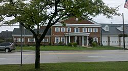
Mayfield Heights City Hall
|
|
| Motto(s):
"A Vibrant Community"
|
|

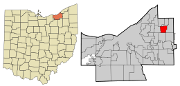
Location in Cuyahoga County and the state of Ohio
|
|
| Country | United States |
| State | Ohio |
| County | Cuyahoga |
| Founded | 1920 |
| Incorporated | 1950 |
| Area | |
| • Total | 4.18 sq mi (10.82 km2) |
| • Land | 4.17 sq mi (10.80 km2) |
| • Water | 0.01 sq mi (0.02 km2) |
| Elevation | 1,086 ft (331 m) |
| Population
(2020)
|
|
| • Total | 20,351 |
| • Density | 4,881.51/sq mi (1,884.87/km2) |
| Time zone | UTC-5 (EST) |
| • Summer (DST) | UTC-4 (EDT) |
| Zip code |
44124 and 44143
|
| Area code(s) | 440 |
| FIPS code | 39-48482 |
| GNIS feature ID | 1056413 |
Mayfield Heights is a city in Cuyahoga County, Ohio, United States. It's a suburb located east of Cleveland. In 2020, about 20,351 people lived there. Mayfield Heights is part of the larger Cleveland metropolitan area.
Contents
History of Mayfield Heights
Mayfield Heights started as a "streetcar suburb." This means it grew because people could easily travel to Cleveland using streetcars. It became a village in 1925 and then a city in 1951.
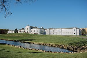
The city got its name from Mayfield Township, which no longer exists. A special building in the city, the W.A. Thorp House, was added to the National Register of Historic Places in 1978. This list helps protect important historical places.
Mayfield Heights has a large community of Italian Americans. Many moved there from Cleveland's "Little Italy" neighborhood. After 1991, many people also moved to Mayfield Heights from Russia and other countries that were once part of the Soviet Union. This makes the city a very diverse place!
Geography of Mayfield Heights
Mayfield Heights is located at 41°31′03″N 81°27′21″W / 41.517402°N 81.455889°W.
The city covers about 4.18 square miles (10.82 square kilometers). Most of this area is land, with a very small amount of water.
People and Languages
| Historical population | |||
|---|---|---|---|
| Census | Pop. | %± | |
| 1930 | 2,612 | — | |
| 1940 | 2,696 | 3.2% | |
| 1950 | 5,807 | 115.4% | |
| 1960 | 13,478 | 132.1% | |
| 1970 | 22,139 | 64.3% | |
| 1980 | 21,550 | −2.7% | |
| 1990 | 19,847 | −7.9% | |
| 2000 | 19,386 | −2.3% | |
| 2010 | 19,155 | −1.2% | |
| 2020 | 20,351 | 6.2% | |
| 2021 (est.) | 20,044 | 4.6% | |
| Sources: | |||
Mayfield Heights is home to people from many different backgrounds. Many residents have Italian (23.9%), German (14.5%), Irish (11.9%), Polish (7.4%), Russian (6.8%), and English (6.4%) ancestry.
Most people in Mayfield Heights speak English at home (81.0%). Other languages spoken include Russian (7.11%), Italian (4.10%), and Arabic (1.03%).
Schools in Mayfield Heights
Mayfield Heights is part of the Mayfield City School District. This school district also serves students from nearby towns like Highland Heights, Mayfield Village, and Gates Mills.
Notable People
Some well-known people have connections to Mayfield Heights:
- Matt Prater, an NFL football player
- Lauren Underwood, a U.S. representative
See also
 In Spanish: Mayfield Heights para niños
 | DeHart Hubbard |
 | Wilma Rudolph |
 | Jesse Owens |
 | Jackie Joyner-Kersee |
 | Major Taylor |


