McGregor, Texas facts for kids
Quick facts for kids
McGregor, Texas
|
|
|---|---|

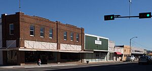
Downtown McGregor
|
|

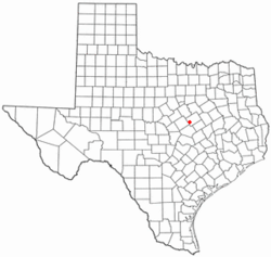
Location of McGregor, Texas
|
|
 |
|
| Country | United States |
| State | Texas |
| Counties | McLennan, Coryell |
| Area | |
| • Total | 21.79 sq mi (56.44 km2) |
| • Land | 21.79 sq mi (56.44 km2) |
| • Water | 0.00 sq mi (0.00 km2) |
| Elevation | 758 ft (231 m) |
| Population
(2020)
|
|
| • Total | 5,338 |
| • Density | 244.96/sq mi (94.58/km2) |
| Time zone | UTC-6 (Central (CST)) |
| • Summer (DST) | UTC-5 (CDT) |
| ZIP code |
76657
|
| Area code(s) | 254 |
| FIPS code | 48-45672 |
| GNIS feature ID | 2411063 |
McGregor is a city in the state of Texas, USA. It's special because it's located in two different counties: McLennan and Coryell. This means parts of the city belong to different larger areas.
As of early 2023, about 5,823 people live in McGregor. The part of the city in McLennan County is near Waco. The smaller part in Coryell County is closer to Killeen and Temple.
Contents
Exploring McGregor's Location
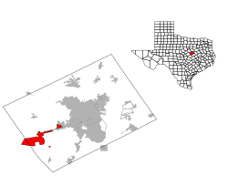
McGregor is in western McLennan County and stretches into Coryell County. It surrounds an area that used to be a Naval Weapons Reserve Plant.
Getting Around McGregor
U.S. Route 84 goes right through the middle of McGregor. You can take it northeast about 17 miles to Waco. Or, you can go west about 20 miles to Gatesville.
Another main road, Texas State Highway 317, crosses US 84 in the city. This highway goes north 15 miles to Valley Mills and south 28 miles to Belton.
McGregor's Size and Climate
The city of McGregor covers about 21.79 square miles (56.4 square kilometers) of land. There is no water area within the city limits.
McGregor has a climate with hot, humid summers. Winters are usually mild to cool. This type of weather is known as a humid subtropical climate.
McGregor's Population Over Time
| Historical population | |||
|---|---|---|---|
| Census | Pop. | %± | |
| 1890 | 774 | — | |
| 1900 | 1,435 | 85.4% | |
| 1910 | 1,864 | 29.9% | |
| 1920 | 2,081 | 11.6% | |
| 1930 | 2,041 | −1.9% | |
| 1940 | 2,062 | 1.0% | |
| 1950 | 2,669 | 29.4% | |
| 1960 | 4,642 | 73.9% | |
| 1970 | 4,365 | −6.0% | |
| 1980 | 4,513 | 3.4% | |
| 1990 | 4,683 | 3.8% | |
| 2000 | 4,727 | 0.9% | |
| 2010 | 4,987 | 5.5% | |
| 2020 | 5,338 | 7.0% | |
| U.S. Decennial Census | |||
The population of McGregor has grown quite a bit over the years. In 1890, there were 774 people. By 2020, the population had reached 5,338.
Who Lives in McGregor?
As of the 2020 census, there were 5,321 people living in McGregor. These people made up 1,714 households.
What McGregor is Known For
McGregor has a history of important industries. It was once home to the Bluebonnet Ordnance Plant. This plant made ammunition during World War II.
Rocket Testing and Manufacturing
After the war, the site became a place for making rockets. Companies like Phillips Petroleum and Rocketdyne used the area.
Today, SpaceX has a special facility in McGregor. This is where they develop and test rocket engines. In 2016, the city passed a rule to help manage the noise from these tests.
New Industries and Famous Homes
In 2021, a company called Knauf Insulation announced plans to build a factory in McGregor. This factory will make fiberglass insulation. It is expected to start making products in 2024.
McGregor is also home to Magnolia House. This is a Victorian-style house that was fixed up on the TV show Fixer Upper. Now, it's a bed and breakfast where people can stay.
Learning in McGregor
Students in McGregor attend schools in two different school districts. These are the McGregor Independent School District and the Midway Independent School District.
Getting Around McGregor
McGregor has a train station called McGregor Station.
See also
 In Spanish: McGregor (Texas) para niños
 | Jackie Robinson |
 | Jack Johnson |
 | Althea Gibson |
 | Arthur Ashe |
 | Muhammad Ali |

