Coryell County, Texas facts for kids
Quick facts for kids
Coryell County
|
|
|---|---|

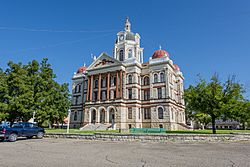
The Coryell County Courthouse in Gatesville, Texas. The courthouse was added to the National Register of Historic Places on August 18, 1977.
|
|

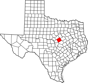
Location within the U.S. state of Texas
|
|
 Texas's location within the U.S. |
|
| Country | |
| State | |
| Founded | 1854 |
| Seat | Gatesville |
| Largest city | Copperas Cove |
| Area | |
| • Total | 1,057 sq mi (2,740 km2) |
| • Land | 1,052 sq mi (2,720 km2) |
| • Water | 4.7 sq mi (12 km2) 0.4% |
| Population
(2020)
|
|
| • Total | 83,093 |
| • Density | 78.61/sq mi (30.352/km2) |
| Time zone | UTC−6 (Central) |
| • Summer (DST) | UTC−5 (CDT) |
| Congressional district | 25th |
Coryell County (pronounced KOR-yel) is a county in the state of Texas, USA. It's located on a high, flat area called the Edwards Plateau. In 2020, about 83,093 people lived here. The main town, or county seat, is Gatesville. The county is named after James Coryell, a brave explorer and Texas Ranger who lived a long time ago. Coryell County is also part of a larger area called the Killeen–Temple metropolitan area.
Contents
History of Coryell County
The land that is now Coryell County has been home to people for a very long time. Early groups like the Tonkawa, Lipan Apache, Kiowa, and Comanche tribes traveled through this area. They lived here as far back as 4500 BC.
How Coryell County Was Formed
In the early 1800s, laws were made to encourage people to settle in Texas. One important land grant was given to Robert Leftwich. This grant later became known as Robertson's Colony. It covered parts of many counties we know today.
Settlers started moving into the area after a military post called Fort Gates was built near what is now Gatesville. The state of Texas officially created Coryell County in 1854. It was named in honor of James Coryell. The county was originally going to be named Pierce County, but this was changed after James Coryell's death.
Geography of Coryell County
Coryell County covers a total area of about 1,057 square miles. Most of this area, about 1,052 square miles, is land. The rest, about 4.7 square miles, is water.
Main Roads in Coryell County
Several important highways run through Coryell County, connecting it to other parts of Texas.
 Interstate 14
 U.S. Highway 84
 U.S. Highway 190
 U.S. Highway 281
 State Highway 36
Neighboring Counties
Coryell County shares borders with several other counties:
- Bosque County (to the north)
- McLennan County (to the northeast)
- Bell County (to the southeast)
- Lampasas County (to the southwest)
- Hamilton County (to the northwest)
People in Coryell County
The population of Coryell County has grown a lot over the years. In 1870, only 412 people lived here. By 2020, the population had grown to 83,093 people. This shows how much the county has developed and attracted new residents.
| Historical population | |||
|---|---|---|---|
| Census | Pop. | %± | |
| 1870 | 412 | — | |
| 1880 | 10,924 | 2,551.5% | |
| 1890 | 16,873 | 54.5% | |
| 1900 | 21,308 | 26.3% | |
| 1910 | 21,703 | 1.9% | |
| 1920 | 20,601 | −5.1% | |
| 1930 | 19,999 | −2.9% | |
| 1940 | 20,226 | 1.1% | |
| 1950 | 16,284 | −19.5% | |
| 1960 | 23,961 | 47.1% | |
| 1970 | 35,311 | 47.4% | |
| 1980 | 56,767 | 60.8% | |
| 1990 | 64,213 | 13.1% | |
| 2000 | 74,978 | 16.8% | |
| 2010 | 75,388 | 0.5% | |
| 2020 | 83,093 | 10.2% | |
| U.S. Decennial Census 1850–2010 2010 2020 |
|||
Communities in Coryell County
Coryell County has several cities, towns, and smaller communities where people live.
Cities
- Copperas Cove (parts are also in Lampasas and Bell counties)
- Gatesville (This is the county seat, where the main county offices are)
- McGregor (most of this city is in McLennan County)
- Oglesby
Towns
- Evant (partly in Hamilton County)
- South Mountain
- Turnersville
Census-Designated Place
- Fort Hood (partly in Bell County)
Unincorporated Communities
These are smaller communities that are not officially part of a city or town.
See also
 In Spanish: Condado de Coryell para niños
 | William M. Jackson |
 | Juan E. Gilbert |
 | Neil deGrasse Tyson |

