Lampasas County, Texas facts for kids
Quick facts for kids
Lampasas County
|
|
|---|---|

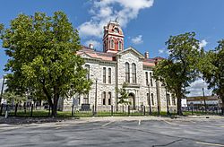
The Lampasas County Courthouse was completed in 1884. The structure was added to the National Register of Historic Places on June 21, 1971.
|
|

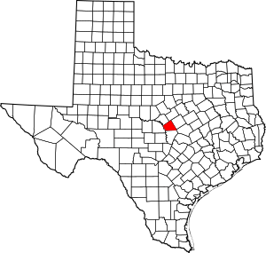
Location within the U.S. state of Texas
|
|
 Texas's location within the U.S. |
|
| Country | |
| State | |
| Founded | 1856 |
| Named for | Lampasas River |
| Seat | Lampasas |
| Largest city | Lampasas |
| Area | |
| • Total | 714 sq mi (1,850 km2) |
| • Land | 713 sq mi (1,850 km2) |
| • Water | 1.1 sq mi (3 km2) 0.2% |
| Population
(2020)
|
|
| • Total | 21,627 |
| • Density | 30.290/sq mi (11.695/km2) |
| Time zone | UTC−6 (Central) |
| • Summer (DST) | UTC−5 (CDT) |
| Congressional district | 11th |
Lampasas County is a county in the state of Texas, USA. It's located on a high flat area called the Edwards Plateau. In 2020, about 21,627 people lived here. The main town and county seat is Lampasas. The county gets its name from the Lampasas River.
Lampasas County is part of the larger Killeen–Temple area. This is a "metropolitan statistical area," which means it's a region with a big city and its surrounding communities that are closely connected.
Contents
History
Early Settlers and County Formation
Long ago, Native American tribes like the Tonkawa, Lipan Apache, and Comanche lived in this area.
In 1756, a Spanish fort was started near Lucy Creek. It was later used by Thomas Isaac Cox to get horses for the American Revolutionary War.
The first permanent settlers arrived in 1853. Moses Hughes and his wife, Hannah, came looking for the healing powers of the local springs. In 1854, John Patterson was the first to farm land in the county.
The town of Burleson was planned in 1855 by Elizabeth and George W. Scott. It was later renamed Lampasas.
Growing as a County
In 1856, the Texas government officially created Lampasas County. It was made from parts of Travis, Bell, and Coryell Counties. The county was named after the Lampasas River, and Lampasas became the county seat.
In 1859, a group called the Lampasas Guards was formed to protect against Native American attacks. By 1860, the county had 1,028 people. During the Civil War (1861), more Native American raids happened because many men were away fighting.
New Developments
Over the years, new businesses and services came to Lampasas County. In 1872, Townsen's Mill was built, which cut lumber and ground wheat and corn. Another mill and cotton gin were built in 1874.
The Farmers' Alliance started in Lampasas in 1875 to deal with cattle theft and unfair land deals. In 1877, there was a famous gunfight at the Lampasas Saloon.
The railroad arrived in Lampasas in 1882, connecting it to other towns. In 1885, the Texas Bankers Association, a very old and large group for banks, began in Lampasas.
Later, in 1920, the Texas Power and Light Company brought electricity to the county. The Lower Colorado River Authority also helped bring more electricity in 1934. A hospital, Rollins-Brook Hospital, opened in 1935.
During World War II, Fort Hood opened nearby in 1942 as a military training base. Hancock Park in Lampasas was used by the soldiers for fun. In 1949, Lone Star Gas started providing gas services.
Geography
Lampasas County covers about 714 square miles. Most of this is land, with only a small part (about 1.1 square miles) being water.
Main Roads
You can travel through Lampasas County on these major highways:
Neighboring Counties
Lampasas County shares borders with these other counties:
- Hamilton County (to the north)
- Coryell County (to the northeast)
- Bell County (to the southeast)
- Burnet County (to the south)
- San Saba County (to the west)
- Mills County (to the northwest)
Population Information
The population of Lampasas County has grown a lot over the years. Here's how it has changed:
| Historical population | |||
|---|---|---|---|
| Census | Pop. | %± | |
| 1860 | 1,028 | — | |
| 1870 | 1,344 | 30.7% | |
| 1880 | 5,421 | 303.3% | |
| 1890 | 7,584 | 39.9% | |
| 1900 | 8,625 | 13.7% | |
| 1910 | 9,532 | 10.5% | |
| 1920 | 8,800 | −7.7% | |
| 1930 | 8,677 | −1.4% | |
| 1940 | 9,167 | 5.6% | |
| 1950 | 9,929 | 8.3% | |
| 1960 | 9,418 | −5.1% | |
| 1970 | 9,323 | −1.0% | |
| 1980 | 12,005 | 28.8% | |
| 1990 | 13,521 | 12.6% | |
| 2000 | 17,762 | 31.4% | |
| 2010 | 19,677 | 10.8% | |
| 2020 | 21,627 | 9.9% | |
| U.S. Decennial Census 1850–2010 2010 2020 |
|||
The people living in Lampasas County come from many different backgrounds. The table below shows the racial and ethnic groups that make up the county's population over the years.
| Race / Ethnicity (NH = Non-Hispanic) | Pop 2000 | Pop 2010 | Pop 2020 | % 2000 | % 2010 | % 2020 |
|---|---|---|---|---|---|---|
| White alone (NH) | 14,121 | 14,836 | 15,132 | 79.50% | 75.40% | 69.97% |
| Black or African American alone (NH) | 511 | 581 | 700 | 2.88% | 2.95% | 3.24% |
| Native American or Alaska Native alone (NH) | 88 | 127 | 115 | 0.50% | 0.65% | 0.53% |
| Asian alone (NH) | 126 | 184 | 242 | 0.71% | 0.94% | 1.12% |
| Pacific Islander alone (NH) | 8 | 35 | 86 | 0.05% | 0.18% | 0.40% |
| Other Race alone (NH) | 8 | 31 | 100 | 0.05% | 0.16% | 0.46% |
| Mixed Race or Multiracial (NH) | 223 | 440 | 1,073 | 1.26% | 2.24% | 4.96% |
| Hispanic or Latino (any race) | 2,677 | 3,443 | 4,179 | 15.07% | 17.50% | 19.32% |
| Total | 17,762 | 19,677 | 21,627 | 100.00% | 100.00% | 100.00% |
In 2000, there were 17,762 people living in the county. About 6,554 homes and 4,876 families were counted. The average household had about 2.66 people.
The population included many young people, with 27.60% being under 18 years old. About 14.50% of the population was 65 years or older. The average age in the county was 37 years.
Communities
Cities
- Copperas Cove (most of it is in Coryell County and a small part in Bell County)
- Kempner
- Lampasas (this is the main town, also called the county seat)
- Lometa
Unincorporated Communities
These are smaller towns or areas that are not officially cities:
- Adamsville
- Bend (partly in San Saba County)
- Izoro
- Moline (partly in Mills County)
- Nix
- Rumley
Ghost Town
- Senterfitt (a town that is no longer inhabited)
See also
 In Spanish: Condado de Lampasas para niños
 | Emma Amos |
 | Edward Mitchell Bannister |
 | Larry D. Alexander |
 | Ernie Barnes |

