Mills County, Texas facts for kids
Quick facts for kids
Mills County
|
|
|---|---|

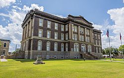
The Mills County Courthouse in Goldthwaite
|
|

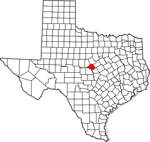
Location within the U.S. state of Texas
|
|
 Texas's location within the U.S. |
|
| Country | |
| State | |
| Founded | 1887 |
| Named for | John T. Mills |
| Seat | Goldthwaite |
| Largest city | Goldthwaite |
| Area | |
| • Total | 750 sq mi (1,900 km2) |
| • Land | 748 sq mi (1,940 km2) |
| • Water | 1.5 sq mi (4 km2) 0.2% |
| Population
(2020)
|
|
| • Total | 4,456 |
| • Density | 5.94/sq mi (2.294/km2) |
| Time zone | UTC−6 (Central) |
| • Summer (DST) | UTC−5 (CDT) |
| Congressional district | 11th |
Mills County is a county located in the middle of Texas, USA. It sits on a high area called the Edwards Plateau. In 2020, about 4,456 people lived here.
The main town and center of the county is Goldthwaite. The county is named after John T. Mills, who was an important judge in the Texas Supreme Court.
Contents
A Look at Mills County's Past

Long ago, the Apache and Comanche people were some of the first to live in this area.
In the late 1700s, an explorer named Pedro Vial traveled through the county. He was mapping a route for Spain from San Antonio to Santa Fe.
In 1828, Captain Henry Stevenson Brown passed through. He was trying to get back cattle that had been taken by Native Americans.
The first person to settle permanently in the county was Dick Jenkins in 1852. A few years later, in 1857, the first church service was held in Charles Mullin's home.
In 1858, a sad event happened at Jackson Springs. Mr. and Mrs. Mose Jackson and two of their children were killed by Native Americans. Two other children were taken away. Later, settlers and Texas Rangers rescued the captive children.
After the Civil War, from 1869 to 1897, there was a lot of lawlessness in Mills County. Groups of people called vigilante committees tried to enforce their own rules. The Texas Rangers had to step in to bring back order.
The town of Goldthwaite was started in 1885. This happened when the Gulf, Colorado and Santa Fe Railway built train tracks through the area.
In 1887, the Texas state government officially created Mills County. It was formed from parts of Brown, Comanche, Hamilton, and Lampasas counties. Goldthwaite was chosen as the county seat.
The first county courthouse was built in 1890. Sadly, it burned down in 1912, and people thought it was set on fire on purpose. A new courthouse was built in 1913. It was made of brick, stone, and concrete.
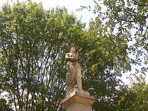
In 1915, a special monument was placed on the courthouse grounds. It was a Confederate Memorial Monument, built with money from public donations and local groups.
Oil was found in Mills County in 1982. This was an important discovery for the county's economy.
Where Mills County Is Located
Mills County covers a total area of about 750 square miles. Most of this is land, about 748 square miles. The rest, about 1.5 square miles, is water.
Neighboring Counties
Mills County shares its borders with these other counties:
- Comanche County (to the north)
- Hamilton County (to the northeast)
- Lampasas County (to the southeast)
- San Saba County (to the southwest)
- Brown County (to the northwest)
Main Roads in the County
Several important highways run through Mills County:
Who Lives in Mills County
| Historical population | |||
|---|---|---|---|
| Census | Pop. | %± | |
| 1890 | 5,493 | — | |
| 1900 | 7,851 | 42.9% | |
| 1910 | 9,694 | 23.5% | |
| 1920 | 9,019 | −7.0% | |
| 1930 | 8,293 | −8.0% | |
| 1940 | 7,951 | −4.1% | |
| 1950 | 5,999 | −24.6% | |
| 1960 | 4,467 | −25.5% | |
| 1970 | 4,212 | −5.7% | |
| 1980 | 4,477 | 6.3% | |
| 1990 | 4,531 | 1.2% | |
| 2000 | 5,151 | 13.7% | |
| 2010 | 4,936 | −4.2% | |
| 2020 | 4,456 | −9.7% | |
| U.S. Decennial Census 1850–2010 2010 2020 |
|||
Population Details from 2020
The table below shows a breakdown of the people living in Mills County in 2010 and 2020. It looks at different groups of people.
| Race / Ethnicity | Pop 2010 | Pop 2020 | % 2010 | % 2020 |
|---|---|---|---|---|
| White alone (NH) | 4,024 | 3,498 | 81.52% | 78.50% |
| Black or African American alone (NH) | 26 | 25 | 0.53% | 0.56% |
| Native American or Alaska Native alone (NH) | 15 | 10 | 0.30% | 0.22% |
| Asian alone (NH) | 10 | 4 | 0.20% | 0.09% |
| Pacific Islander alone (NH) | 1 | 0 | 0.02% | 0.00% |
| Some Other Race alone (NH) | 0 | 6 | 0.00% | 0.13% |
| Mixed Race/Multi-Racial (NH) | 42 | 185 | 0.85% | 4.15% |
| Hispanic or Latino (any race) | 818 | 728 | 16.57% | 16.34% |
| Total | 4,936 | 4,456 | 100.00% | 100.00% |
Note: The U.S. Census counts people who are Hispanic/Latino as a separate group based on their background. This means they are not included in the other race categories in this table.
Towns and Communities
City
- Goldthwaite (This is the county seat, meaning it's the main administrative town.)
Town
Small Communities (Unincorporated)
Old or Abandoned Towns
- Williams Ranch (This is a "ghost town," meaning it's mostly abandoned.)
See also
 In Spanish: Condado de Mills para niños
 | Janet Taylor Pickett |
 | Synthia Saint James |
 | Howardena Pindell |
 | Faith Ringgold |

