Comanche County, Texas facts for kids
Quick facts for kids
Comanche County
|
|
|---|---|

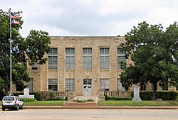
The Comanche County Courthouse in Comanche
|
|

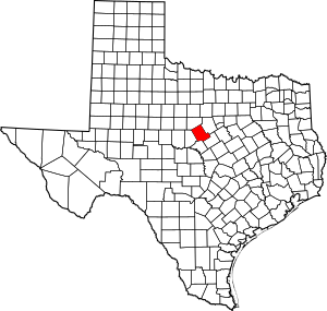
Location within the U.S. state of Texas
|
|
 Texas's location within the U.S. |
|
| Country | |
| State | |
| Founded | 1856 |
| Named for | Comanche tribe |
| Seat | Comanche |
| Largest city | Comanche |
| Area | |
| • Total | 948 sq mi (2,460 km2) |
| • Land | 938 sq mi (2,430 km2) |
| • Water | 9.9 sq mi (26 km2) 1.0% |
| Population
(2020)
|
|
| • Total | 13,594 |
| • Density | 14.340/sq mi (5.5366/km2) |
| Time zone | UTC−6 (Central) |
| • Summer (DST) | UTC−5 (CDT) |
| Congressional district | 25th |
Comanche County is a county located in Central Texas, on a high area called the Edwards Plateau. In 2020, about 13,594 people lived here. The main town and county seat is Comanche. The county was started in 1856 and is named after the Comanche Native American tribe, who were among the first people to live in this area.
Contents
History of Comanche County
Early Days and Founding
The Comanche Native American tribe were some of the first people to live in this region. In 1854, a group led by Jesse M. Mercer started a new community near what would become Newburg. This area was part of lands given by Mexico to early Texas settlers like Stephen F. Austin. The first log house in the county was built by Frank M. Collier.
In 1856, the Texas government officially created Comanche County. It was formed from parts of Coryell and Bosque counties. The first county seat was a place called Cora. However, in 1859, the town of Comanche became the new county seat. By 1860, about 709 people lived in the county.
Growth and Changes
Newspapers started in the county, with the Comanche Chief beginning in 1873. A famous geologist named Robert T. Hill even worked on this newspaper for a time.
In 1885, the Texas Central Railroad began running through Comanche County. This was a big deal because it helped farmers and ranchers send their goods, like cattle and cotton, to markets.
Cotton became a very important crop in the county by 1890. However, a small insect called the boll weevil caused a lot of damage to the cotton farms for about 30 years. Because of this, farmers started looking for other crops. In 1907, they began trying to grow peanuts.
Oil was discovered in a town called Desdemona in 1910, which led to an "oil boom" in the county. The busiest year for oil production was 1920. Around this time, more than 70,000 fruit trees were also grown in the county.
Modern Times
In the early 1950s, the county faced a very bad drought. People even tried to make it rain! To help with water supply and prevent floods, Proctor Lake was built in 1963.
Comanche County became a major peanut-producing area. By 1982, it was ranked second in Texas for peanut production, growing over 45 million pounds!
A person from Comanche County named Jim Reese became the mayor of Odessa from 1968 to 1974. He also tried to become a member of Congress.
Geography
Comanche County covers about 948 square miles. Most of this area is land (938 square miles), and a small part is water (about 9.9 square miles). The county is located about 60 miles north of the very center of Texas.
A notable feature in the county is Proctor Lake, which is important for water and recreation.
Neighboring Counties
Comanche County shares its borders with several other counties:
- Erath County (to the northeast)
- Hamilton County (to the southeast)
- Mills County (to the south)
- Brown County (to the southwest)
- Eastland County (to the northwest)
People of Comanche County (Demographics)
In 2020, the population of Comanche County was 13,594 people. The county has a mix of different backgrounds, with people of various races and ethnicities living together.
The average household in 2000 had about 2.48 people, and the average family had about 2.98 people. About 29.8% of households had children under 18 living with them.
The median age in the county in 2000 was 40 years old. This means half the people were younger than 40 and half were older. About 25.3% of the population was under 18, and 20.3% was 65 or older.
Getting Around (Transportation)
Main Roads
Several important highways pass through Comanche County, helping people travel and transport goods:
Airport
The Comanche County-City Airport is located just a couple of miles northeast of the main town of Comanche.
News and Media
Comanche County is part of the larger Dallas-Fort Worth media area. This means people in the county can watch TV channels from that big city area.
There are also two local newspapers that serve Comanche County: the Comanche Chief and the De Leon Free Press.
Communities
Comanche County has several towns and communities:
Cities
Town
Smaller Communities
Ghost Towns
These are places where towns used to be, but now very few or no people live there:
- Cora
- Mercer's Gap
- Suez
Education
Students in Comanche County attend schools in various school districts. Some of these include:
- Blanket Independent School District
- Comanche Independent School District
- De Leon Independent School District
- Dublin Independent School District
- Gorman Independent School District
- Gustine Independent School District
- Hamilton Independent School District
- Hico Independent School District
- Lingleville Independent School District
- May Independent School District
- Mullin Independent School District
- Priddy Independent School District
- Rising Star Independent School District
- Sidney Independent School District
- Zephyr Independent School District
For college, the county is part of the Ranger College district.
See also
 In Spanish: Condado de Comanche (Texas) para niños
Comanche County from the Handbook of Texas Online
 |
Eastland County | Erath County |  |
|
| Brown County | Mills County | Hamilton County |
 | Sharif Bey |
 | Hale Woodruff |
 | Richmond Barthé |
 | Purvis Young |

