San Saba County, Texas facts for kids
Quick facts for kids
San Saba County
|
|
|---|---|

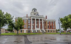
The San Saba County Courthouse in San Saba with emblem "From the People to the People."
|
|

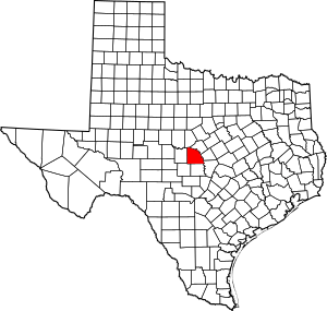
Location within the U.S. state of Texas
|
|
 Texas's location within the U.S. |
|
| Country | |
| State | |
| Founded | 1856 |
| Named for | San Saba River |
| Seat | San Saba |
| Largest town | San Saba |
| Area | |
| • Total | 1,138 sq mi (2,950 km2) |
| • Land | 1,135 sq mi (2,940 km2) |
| • Water | 3.1 sq mi (8 km2) 0.3% |
| Population
(2020)
|
|
| • Total | 5,730 |
| • Density | 5.035/sq mi (1.9441/km2) |
| Time zone | UTC−6 (Central) |
| • Summer (DST) | UTC−5 (CDT) |
| Congressional district | 11th |
San Saba County is a county located in the western part of Central Texas, United States. It's found on a high area of land called the Edwards Plateau. In 2020, about 5,730 people lived here.
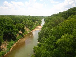
The main town and county seat is San Saba. The county gets its name from the San Saba River, which flows through the area.
Contents
History of San Saba County
After the American Civil War, a group called the United Confederate Veterans formed a local chapter in San Saba County. It was named the "William P. Rogers Camp." This group was created after the death of Confederate President Jefferson Davis in 1889.
William P. Rogers was a hero from the Second Battle of Corinth in Mississippi. He was from Georgia and never lived in San Saba. However, his daughter, Fannie, married one of Rogers' officers, George Harris. George Harris moved to San Saba in 1880. He later led the Rogers Camp. This group of veterans continued until the early 1930s.
Important Dates in San Saba County
- Early People: The first people to live here were Native American tribes like the Tonkawa, Caddo, Apache, and Comanche.
- 1732 - River Named: A Spanish governor named Juan Antonio Bustillo y Ceballos arrived on a special day for a monk named St. Sabbas. He named the river Río de San Sabá de las Nueces.
- 1757 - Mission Built: The Santa Cruz de San Sabá Mission was built.
- 1788 - Exploration: José Mares led a trip from San Antonio to Santa Fe.
- 1828 - Early Settlers: Twenty-eight people from Stephen F. Austin's group traveled through the area. Some of the county's land was part of Austin’s grants from the Mexican government.
- 1842 - Land Grants: Most of the land deeds later came from the Fisher–Miller Land Grant.
- 1847 - Peace Treaty: The Meusebach–Comanche Treaty was signed in San Saba County. This was an important peace agreement.
- 1854 - First Families: The Harkey family settled near Wallace and Richland Creeks. The David Matsler family moved from Burnet County to Cherokee Creek.
- 1856 - County Formed: San Saba County was officially created from Bexar County. It was named after the San Saba River. San Saba was chosen as the county seat, which is the main government town.
- 1858 - Borders Set: The state government confirmed the county's boundaries.
- 1860 - Population: The county had 913 people, including 98 enslaved people.
- 1867 - Schools Begin: The county was divided into 10 school areas.
- 1874 - Pecan Focus: Edmund E. Risen worked to improve local nuts, especially the pecan. San Saba later became known as the "Pecan Capital of the World."
- 1882 - Academy Founded: The San Saba Male and Female Academy was started.
- 1889 - Veterans Group: The United Confederate Veterans William P. Rogers Camp No. 322 was formed.
- 1895 - College Opens: The West Texas Normal and Business College was organized.
- 1896 - Beveridge Bridge: The Beveridge Bridge was built across the San Saba River.
- 1911 - Railway Arrives: A railway branch was built through San Saba County. The San Saba County courthouse, made of brick and sandstone, was also built.
- 1930 - Farming Changes: Half of the county's farms were worked by tenant farmers. Uncle Billy Gibbons gave the Boy Scouts of America a long-term lease for campgrounds along Brady Creek.
- 1938 - Big Flood: San Saba River floods caused a lot of damage. One-third of the town of San Saba was underwater.
- 1940 - Town Incorporated: The Town of San Saba officially became an incorporated town.
- 1953-56 - Drought: A long period of dry weather made farming very difficult.
- 1960 - Newspapers Merge: The San Saba County News and the San Saba Star newspapers joined together.
- 1965 - Historical Marker: A marker was put up to honor pioneer doctor Edward D. Doss.
Geography of San Saba County

The county covers a total area of about 1,138 square miles. Most of this, 1,135 square miles, is land. Only about 3.1 square miles (0.3%) is water.
Main Roads
Neighboring Counties
- Mills County (north)
- Lampasas County (east)
- Burnet County (southeast)
- Llano County (south)
- Mason County (southwest)
- McCulloch County (west)
- Brown County (northwest)
People of San Saba County
| Historical population | |||
|---|---|---|---|
| Census | Pop. | %± | |
| 1860 | 913 | — | |
| 1870 | 1,425 | 56.1% | |
| 1880 | 5,324 | 273.6% | |
| 1890 | 6,641 | 24.7% | |
| 1900 | 7,569 | 14.0% | |
| 1920 | 10,045 | — | |
| 1930 | 10,273 | 2.3% | |
| 1940 | 11,012 | 7.2% | |
| 1950 | 8,666 | −21.3% | |
| 1960 | 6,381 | −26.4% | |
| 1970 | 5,540 | −13.2% | |
| 1980 | 5,693 | 2.8% | |
| 1990 | 5,401 | −5.1% | |
| 2000 | 6,186 | 14.5% | |
| 2010 | 6,131 | −0.9% | |
| 2020 | 5,730 | −6.5% | |
| U.S. Decennial Census 1850–2010 2010 2020 |
|||
| Race / Ethnicity (NH = Non-Hispanic) | Pop 2000 | Pop 2010 | Pop 2020 | % 2000 | % 2010 | % 2020 |
|---|---|---|---|---|---|---|
| White alone (NH) | 4,622 | 4,135 | 3,690 | 74.72% | 67.44% | 64.40% |
| Black or African American alone (NH) | 160 | 194 | 106 | 2.59% | 3.16% | 1.85% |
| Native American or Alaska Native alone (NH) | 26 | 28 | 29 | 0.42% | 0.46% | 0.51% |
| Asian alone (NH) | 5 | 13 | 16 | 0.08% | 0.21% | 0.28% |
| Pacific Islander alone (NH) | 0 | 0 | 1 | 0.00% | 0.00% | 0.02% |
| Other Race alone (NH) | 6 | 1 | 10 | 0.10% | 0.02% | 0.17% |
| Mixed Race or Multiracial (NH) | 34 | 45 | 129 | 0.55% | 0.73% | 2.25% |
| Hispanic or Latino (any race) | 1,333 | 1,715 | 1,749 | 21.55% | 27.97% | 30.52% |
| Total | 6,186 | 6,131 | 5,730 | 100.00% | 100.00% | 100.00% |
In 2010, there were 6,131 people living in San Saba County. There were 2,289 households, and 1,616 families. The population density was about 6 people per square mile.
About 29.10% of households had children under 18 living with them. Most households (58.90%) were married couples. About 27.5% of all households were single people. Around 15.90% of households had someone aged 65 or older living alone.
The average household had 2.45 people, and the average family had 2.97 people. The median age in the county was 39 years old. For every 100 females, there were about 107 males.
Fun Things to Do in San Saba County
San Saba County has the only suspension bridge in Texas that cars can still drive on. It's called the Regency Bridge and crosses the Colorado River. You can find it off FM 500 in the northern part of the county. It was built in 1939.
Another suspension bridge, the Beveridge Bridge, was built in 1896 over the San Saba River. It was also open to cars until 2004, when a new concrete bridge replaced it. The Beveridge Bridge has been fixed up and is now a bridge just for people walking. It's on China Creek Road, near the town of San Saba.
San Saba County is also famous for its success in Texas six-man football. This is a special type of football played with fewer players. The towns of Richland Springs (with their team, the Richland Springs Coyotes) and Cherokee (the Cherokee Indians) have won a total of 11 state championships! Richland Springs has won eight championships, and Cherokee has won three.
Towns and Communities
Towns
- Richland Springs
- San Saba (This is the county seat, where the main government offices are.)
Unincorporated Communities
- Bend (partly in Lampasas County)
- Bowser
- Cherokee
Famous People from San Saba County
The actor Tommy Lee Jones was born in San Saba. He also owns a ranch outside of town. Aaron Behrens, who is the lead singer for the music group Ghostland Observatory, is also from here.
See also
 In Spanish: Condado de San Saba para niños
 | James B. Knighten |
 | Azellia White |
 | Willa Brown |

