Copperas Cove, Texas facts for kids
Quick facts for kids
Copperas Cove, Texas
|
||
|---|---|---|
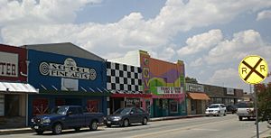
Downtown Copperas Cove (prior to 2010)
|
||
|
||
| Nickname(s):
City of Five Hills
|
||
| Motto(s):
"The City Built for Family Living"
|
||
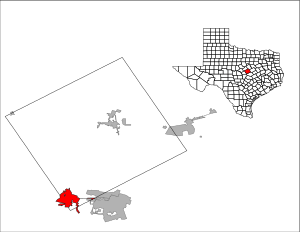
Location of Copperas Cove in Texas
|
||
| Country | ||
| State | ||
| Counties | Coryell, Lampasas, Bell | |
| Founded | March 25, 1879 | |
| Incorporated | 1913 | |
| Government | ||
| • Type | Council-Manager | |
| Area | ||
| • Total | 18.04 sq mi (46.71 km2) | |
| • Land | 18.03 sq mi (46.71 km2) | |
| • Water | 0.00 sq mi (0.00 km2) | |
| Elevation | 1,125 ft (343 m) | |
| Population
(2020)
|
||
| • Total | 36,670 | |
| • Density | 2,032.7/sq mi (785.06/km2) | |
| • Demonym | Covite | |
| Time zone | UTC-6 (Central (CST)) | |
| • Summer (DST) | UTC-5 (CDT) | |
| ZIP code |
76522
|
|
| Area code(s) | 254 | |
| FIPS code | 48-16624 | |
| GNIS feature ID | 2410225 | |
Copperas Cove (pronounced KOP-er-us) is a city in central Texas. It is mostly in Coryell County, with small parts in Lampasas and Bell counties.
The city started in 1879 as a small community for ranching and farming. Today, it is the biggest city in Coryell County. In 2020, about 36,670 people lived there. Copperas Cove's economy is closely connected to Fort Cavazos, a large military base nearby. This makes it part of the bigger Killeen-Temple-Fort Hood Metropolitan Statistical Area.
Contents
History of Copperas Cove
Early Days and First Settlers
People have lived in the "Five Hills" area around Copperas Cove for a very long time. Scientists have found old tools and bones from as far back as 4,000 BC. These first people were hunters who moved around, following buffalo herds.
When the Spanish arrived in Texas, a Native American tribe called the Tonkawa lived in this area. The powerful Comanche tribe controlled lands to the north and west. This made Coryell County a challenging place as new settlers moved in.
In 1825, Mexico gave Stephen F. Austin a large piece of land that included what is now Copperas Cove. The first European settlers came to the Five Hills region in the 1830s. But the area did not become stable until after the American Civil War.
How Copperas Cove Got Its Name
More people settled here in the 1870s because of the growing cattle industry. A path for cattle, part of the Chisholm Trail, went through the region. People gathered around a general store about two miles southwest of today's downtown.
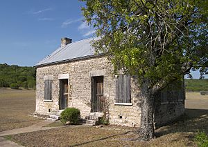
In 1878, residents asked for a post office. They wanted to call it "Cove" because the spot was sheltered. But another community nearby already used that name. So, they added "Copperas" to the name. This was inspired by the taste of nearby spring water, which contained copperas. The post office officially opened in March 1879. The original building is still there and hosts a festival today.
Growth with the Railroad
Copperas Cove grew a lot when the Gulf, Colorado and Santa Fe Railway came to the area in 1882. A local resident, Jesse M. Clements, helped bring the train service. He gave the railroad company the land they needed.
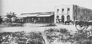
Residents soon moved to new streets that the railroad company planned. The train station in Copperas Cove became a shipping point for farmers and ranchers. Many businesses opened to serve these people, like a cotton gin, hotels, and a barber shop. Many of the town's early buildings are still standing today.
By 1900, about 475 people lived in Copperas Cove. In 1913, residents elected Jouett Allin as their first mayor. The town continued to do well, mostly because of farming, especially cotton. Copperas Cove reached a population of 600 in 1929.
The Great Depression and Fort Cavazos
The town faced hard times during the Great Depression in the 1930s. The local bank closed, businesses shut down, and many people left to find work. By 1940, only 356 people remained.
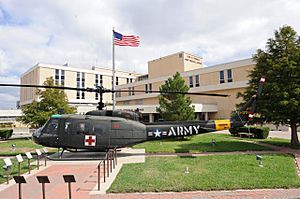
In 1942, Copperas Cove got a new start when the U.S. government built Camp Hood next to the town. This military camp later became Fort Hood in 1950. The town's population grew very quickly after that. It reached almost 5,000 people in 1960. The population kept doubling in the following decades.
The military base changed the city a lot. Soldiers and their families moved to Copperas Cove. Many stayed even after leaving the military. This made the city more diverse. Fort Hood also changed the local economy. Since much of the farmland was used for the base, businesses in Copperas Cove now mostly serve military families. In 2023, Fort Hood was renamed Fort Cavazos.
Geography and Climate
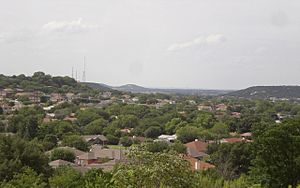
Copperas Cove is in central Texas, in an area called the "Five Hills." This area is between the Lampasas River and Cowhouse Creek.
Weather in Copperas Cove
Copperas Cove has a humid subtropical climate. This means it has hot summers, cool winters, and rainy springs. The average high temperature in August is about 96°F (36°C). The average low in January is about 35°F (2°C). May is usually the wettest month.
The city is in Tornado Alley, so tornadoes can happen here. The area gets about 33 inches (84 cm) of rain each year. This is enough for farming without extra watering, but droughts can still occur.
Natural Environment
The top layer of soil in the area is thin and crumbly. It can support many farm plants but can wear away easily. Before farms and ranches changed the land, it was a large grassland. Animals like Bison, deer, and pronghorn ate the tall native grasses.
However, because of too much grazing and land clearing, these native grasses have mostly been replaced. Now, you can find tough, woody trees like Texas live oak, Texas red oak, red juniper, and mesquite.
City Layout
Copperas Cove looks like many small American towns built after World War II. Most of the shops and businesses are along the main road, US Highway 190. Since most of Copperas Cove was built after 1950, its old downtown area is smaller than in nearby towns. Most homes are single-family houses spread out over the land.
Because of changes in the economy, large-scale farming and ranching have mostly left the area. This has made land cheaper to build on. After a short period of slower growth in the 1980s, new neighborhoods started expanding into the countryside again.
| Climate data for Copperas Cove, Texas | |||||||||||||
|---|---|---|---|---|---|---|---|---|---|---|---|---|---|
| Month | Jan | Feb | Mar | Apr | May | Jun | Jul | Aug | Sep | Oct | Nov | Dec | Year |
| Mean daily maximum °F (°C) | 58 (14) |
63 (17) |
70 (21) |
78 (26) |
84 (29) |
91 (33) |
95 (35) |
96 (36) |
89 (32) |
80 (27) |
68 (20) |
60 (16) |
78 (26) |
| Mean daily minimum °F (°C) | 36 (2) |
38 (3) |
45 (7) |
53 (12) |
61 (16) |
69 (21) |
72 (22) |
71 (22) |
65 (18) |
56 (13) |
44 (7) |
38 (3) |
54 (12) |
| Average precipitation inches (mm) | 1.7 (43) |
2.5 (64) |
2.9 (74) |
2.5 (64) |
4.5 (110) |
3.7 (94) |
1.3 (33) |
1.9 (48) |
3.1 (79) |
3.2 (81) |
2.9 (74) |
2.7 (69) |
32.9 (840) |
| Source: weather.com | |||||||||||||
Transportation in Copperas Cove
The main road through Copperas Cove is Interstate 14/U.S. Highway 190. This road connects Copperas Cove to Interstate 35 in Belton, about 28 miles (45 km) to the east. It also connects to U.S. Highway 281 in Lampasas, about 19 miles (31 km) to the west. FM 116 goes north through the city, connecting it to Gatesville, about 26 miles (42 km) away.
For public transportation within the city, there are HOP buses. These buses are easy to spot because they are teal and purple. The nearest airport is Killeen Regional Airport (GRK), which is a few miles outside of town.
Population and People
| Historical population | |||
|---|---|---|---|
| Census | Pop. | %± | |
| 1900 | 475 | — | |
| 1910 | 490 | 3.2% | |
| 1920 | 509 | 3.9% | |
| 1930 | 406 | −20.2% | |
| 1940 | 356 | −12.3% | |
| 1950 | 1,052 | 195.5% | |
| 1960 | 4,567 | 334.1% | |
| 1970 | 10,818 | 136.9% | |
| 1980 | 24,519 | 126.7% | |
| 1990 | 24,079 | −1.8% | |
| 2000 | 29,592 | 22.9% | |
| 2010 | 32,032 | 8.2% | |
| 2020 | 36,670 | 14.5% | |
| U.S. Decennial Census | |||
2020 Census Information
The 2020 United States census counted 36,670 people living in Copperas Cove. There were 12,632 households and 8,911 families.
The table below shows the different groups of people living in Copperas Cove in 2020. "NH" means "Non-Hispanic."
| Race | Number | Percentage |
|---|---|---|
| White (NH) | 17,872 | 48.74% |
| Black or African American (NH) | 6,431 | 17.54% |
| Native American or Alaska Native (NH) | 172 | 0.47% |
| Asian (NH) | 1,021 | 2.78% |
| Pacific Islander (NH) | 793 | 2.16% |
| Some Other Race (NH) | 258 | 0.7% |
| Mixed/Multi-Racial (NH) | 2,839 | 7.74% |
| Hispanic or Latino | 7,284 | 19.86% |
| Total | 36,670 |
Economy of Copperas Cove
The economy of Copperas Cove is strongly linked to Fort Cavazos. Many people in the city work at the military base. The table below shows the top employers in Copperas Cove in 2020.
| # | Employer | # of Employees |
|---|---|---|
| 1 | Fort Cavazos – Military | 36,739 |
| 2 | Fort Cavazos – Civilian | 14,445 |
| 3 | Copperas Cove Independent School District | 1,300 |
| 4 | GC Services | 1,250 |
| 5 | HEB Grocery Store | 333 |
| 6 | Wal-Mart | 297 |
| 7 | City of Copperas Cove | 294 |
| 8 | Copperas Cove Nursing and Rehabilitation | 112 |
| 9 | Hill Country Rehabilitation and Nursing Center | 80 |
| 10 | Cinergy | 77 |
Fun Annual Events and Festivals
Copperas Cove hosts several fun events and festivals throughout the year:
- Rabbit Fest is a four-day arts and crafts festival. It happens every year on the third weekend of May. You can enjoy a carnival, a parade, a chili cook-off, and many other activities.
- The Ogletree Gap Heritage Festival takes place at the city's original town site, the Ogletree Gap Stagecoach and Post Office. It's held annually on the third weekend of October. This festival offers food, arts and crafts, and activities like a petting zoo and pony rides.
- The Krist Kindl Markt is a German-inspired outdoor Christmas market. It's held in downtown Copperas Cove on the first weekend of December. You can enjoy live music and performances by local groups. There is also a night-time Christmas parade.
- The Copperas Cove Classic Road Race started in 2000. This bike race covers 83 miles (134 km) of the city's hilly roads. It takes place in mid-January each year.
- The C.H.A.M.P.S. Heart of Texas Bowl is a football game hosted in Copperas Cove at Bulldawg Stadium. The first HOT Bowl was held in 2001.
Notable People from Copperas Cove
- Robert Griffin III, a famous Heisman Trophy-winner and NFL quarterback.
- Shaye Haver, a U.S. Army 1st Lieutenant, was born in Copperas Cove.
- Suzanna Hupp, a survivor of the Luby's massacre and former Texas House of Representatives member.
- Rashard Odomes (born 1996), a basketball player in the Israeli Basketball Premier League.
- Chester M. Ovnand, one of the first two American soldiers killed in South Vietnam.
- Michael Stipe, the lead singer of the band R.E.M., lived in Copperas Cove.
- Charles Tillman, a retired cornerback for the Chicago Bears and Carolina Panthers.
See also
 In Spanish: Copperas Cove para niños
 | Isaac Myers |
 | D. Hamilton Jackson |
 | A. Philip Randolph |


