Mead, Washington facts for kids
Quick facts for kids
Mead, Washington
|
|
|---|---|

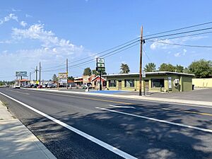
Commercial district along Market Street
|
|
| Country | United States |
| State | Washington |
| County | Spokane County |
| Named for | George Meade |
| Area | |
| • Land | 7.26 sq mi (18.8 km2) |
| Population
(2020)
|
|
| • Total | 7,576 |
| • Density | 1,043/sq mi (403/km2) |
| Zip Code |
99201, 99217
|
| Area code(s) | 509 |
Mead is a community located just north of Spokane in Spokane County, Washington, United States. It is named after George Meade, a famous general from the American Civil War. The United States Census Bureau keeps track of information about this area. In 2020, about 7,576 people lived in Mead.
In the year 1900, Mead was an important stop on the Spokane Falls & Northern Railway. The community had a general store called Cushing & Bryant. There was also a blacksmith shop and a public school with about 60 students. Mead also had a Methodist Episcopal church and a Sunday school. The post office was located inside the Cushing & Bryant store.
Mead is home to Cyan Worlds, a company that makes computer games. They created famous games like Myst and Riven. The Kaiser Aluminum Mead Works was a big employer in the area. It operated from 1942 until 2001.
Contents
Discovering Mead's Location
Mead is found in Spokane County, just north of the city of Spokane. It is near the Hillyard and Shiloh Hills neighborhoods. To the west is Fairwood, and to the south is Colbert.
A stream called Deadman Creek flows through Mead. It runs from east to west before joining the Little Spokane River. This creek divides Mead into two main developed areas.
Mead's Layout and Roads
The older, southern part of Mead is bordered by U.S. Route 395 on the west. A railroad track runs along its eastern side. The newer northern part of Mead is on both sides of Highway 2. These two major roads meet at a large interchange on Mead's western edge.
Mead includes the original townsite in the south and newer neighborhoods to the north. Both areas are connected and form part of the larger Spokane urban area.
The original townsite has streets named 1st Avenue through 4th Avenue. It also has a Main Street, which is different from Spokane's Main Street. Mead is well-connected to northern Spokane by Highway 2 and U.S. Route 395. It is also the start of Washington State Route 206. Market Street links Mead to Hillyard in the south. Farwell Road connects Mead to Fairwood in the west.
Mead's Flat Terrain
The land in Mead is mostly flat, sitting about 1,900 feet above sea level. However, the Deadman Creek valley is lower, below 1,800 feet. Some nearby hills to the south and southeast rise above 2,300 feet.
Getting Around Mead: Transportation
Mead has several important roads that help people travel in and out of the community.
 State Route 206
- Highway 206 goes from west to east through Mead. It starts at U.S. Route 2 and goes towards Mount Spokane.
Learning in Mead: Education
The Mead School District is named after the town of Mead. Its first school was built here. The district serves about 9,000 students. It has two high schools, two middle schools, and eight elementary schools.
Until 2019, the district offered two special high schools. Riverpoint Academy focused on project-based learning in science, technology, engineering, arts, and math (STEAM+). M.E.A.D. was an alternative high school. Both schools closed in 2019 due to financial and political reasons.
The Mead School District covers a large part of northern Spokane County. It stretches from Mount Spokane in the east to the Stevens County line in the west. While the community of Mead gave its name to Mead High School, that school is actually in neighboring Fairwood. Students who live in Mead now attend Mount Spokane High School. This school is just west of Mead on Washington State Route 206.
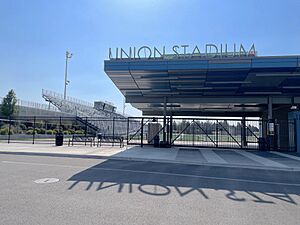
Both Mead High School and Mount Spokane High School share a sports facility. It is called Union Stadium and is located in Mead. The stadium cost $24 million to build. This project was approved by voters in 2018.
Completed in 2020, Union Stadium has 4,500 seats. It is the home field for the football teams from both high schools in the Mead School District. It replaced Joe Albi Stadium in Spokane, where the teams used to play.
See also
 In Spanish: Mead (Washington) para niños


