Mecca Hills facts for kids
Quick facts for kids Mecca Hills |
|
|---|---|
 |
|
| Highest point | |
| Elevation | 1,239 ft (378 m) |
| Geography | |
| Country | United States |
| State | California |
| Region | Colorado Desert |
| District | Riverside County |
| Range coordinates | 33°37′43″N 116°01′00″W / 33.62861°N 116.01667°W |
| Topo map | USGS Thermal Canyon |
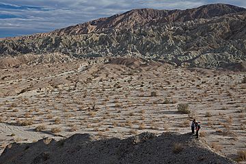
The Mecca Hills are a unique low mountain range found in Riverside County, southern California. They are part of the vast Colorado Desert, which is a section of the larger Sonoran Desert.
These hills stretch from east to west. You can find them east of the Coachella Valley and west of the Chuckwalla Mountains. They are also south of Interstate 10, north of the Salton Sea, and south of Joshua Tree National Park. The Orocopia Mountains are located to their southeast.
Exploring the Mecca Hills Wilderness
The Mecca Hills are home to a special protected area called the Mecca Hills Wilderness. The U.S. Congress created this wilderness in 1994. It covers a huge area of 26,356 acres! The U.S. Bureau of Land Management helps to look after this amazing natural space.
What Makes This Wilderness Special?
Inside the Mecca Hills Wilderness, you'll discover narrow canyons with very steep walls. These canyons form a natural maze, almost like a puzzle, within the badlands. The badlands are areas with soft rock that has been carved by wind and water.
One of the most exciting things about the Mecca Hills is their geology. The rocks here are uniquely folded and faulted. This means they have been bent and broken in unusual ways. This happened because of activity along the famous San Andreas Fault, which runs nearby. These special rock formations make the Mecca Hills one of the most interesting geological sites of its kind!
 | Janet Taylor Pickett |
 | Synthia Saint James |
 | Howardena Pindell |
 | Faith Ringgold |


