Middleton Junction facts for kids
Quick facts for kids Middleton Junction |
|
|---|---|
| OS grid reference | SD 88768 04870 |
| Metropolitan borough |
|
| Metropolitan county | |
| Region | |
| Country | England |
| Sovereign state | United Kingdom |
| Post town | MANCHESTER |
| Postcode district | M24 |
| Dialling code | 0161 |
| Police | Greater Manchester |
| Fire | Greater Manchester |
| Ambulance | North West |
| EU Parliament | North West England |
| UK Parliament |
|
Middleton Junction is a busy area with homes and businesses. It sits right on the border between Middleton and Chadderton. Both of these towns are part of Greater Manchester.
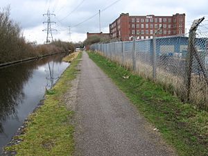
The name "Middleton Junction" comes from an old railway station that used to be here. The area also runs along the Rochdale Canal. It is about 1.4 miles (2.3 km) southeast of Middleton town centre. It is also 1.9 miles (3.1 km) west of central Chadderton.
Middleton Junction is connected to other nearby places. These include Moorclose, Mills Hill, Greengate, Alkrington, and Firwood Park. To the east, you'll find the more rural area of Foxdenton.
Contents
History of Middleton Junction
The area we now call Middleton Junction was once made up of several small villages. These villages were located along Grimshaw Lane and Foxdenton Lane. Some of these old villages were Lane End and Hillock in Chadderton. Others were Bradshaw Fold and Jumbo in Tonge. Tonge was a separate area that later became part of Middleton.
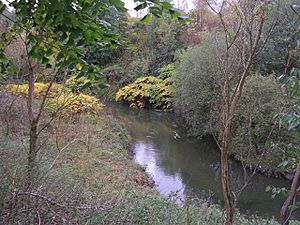
The land around Jumbo was historically part of the Bradshaw Hall estate. This old hall was taken down in 1910. In the 1500s, this area was mostly undeveloped. It had lots of forests and open fields. The hall had a corn mill by the Wince Brook. Land was rented out to farmers.
Silk Weaving and Growth
In 1777, silk weaving started in the area. For the next 50 years, many homes were built for hand loom weavers. The estate rented land north of Grimshaw Lane. This led to the quick growth of Jumbo and Bradshaw Fold. The Wince Brook bordered the estate to the south. Tonge was to the west, and Chadderton to the north. The only main road was the lane to Foxdenton Hall, which later became Grimshaw Lane.
Two main settlements grew here. First, there were homes for weavers. Later, mill owners built more. Bradshaw Fold was in the northeast part of the estate. It was later known as Middleton Junction because of the station. In 1861, Bradshaw Fold had over 70 weavers' cottages.
To the west, between Aspinall Street and Sandy Lane, was the village of Jumbo. The name "Jumbo" might have come from a slang word meaning a "clumsy fellow." Some people thought it came from the energetic dancing of local residents on holidays.
Industry and Transport
In 1779, the rights to mine coal were sold. This coal was likely taken from the Alkrington pit. The Rochdale Canal was built soon after, in 1804. This canal made it much easier to move coal and cotton.
The JW Lees brewery opened in Bradshaw Fold in 1828. It is still a well-known brewery today.
The Middleton Junction railway station opened on March 31, 1842. It had a line going to Oldham Werneth railway station. The railway line actually split the small village of Lane End in two. The station was first called Oldham Junction. By August 1842, it was known as Middleton Station. About ten years later, it became Middleton Junction. A branch line to Middleton opened in 1857. The station closed in the mid-1960s.
By the late 1800s, many cotton spinning mills were built near the station and along the canal. Terraced houses were also built along Grimshaw Lane. Famous mills included the Junction Mill and Laurel Mill. The name Middleton Junction became the official name for the whole area during this time.
Bradshaw Hall Estate
The Bradshaw Hall estate was an important part of the old land system in North Manchester. Members of the Chadderton family lived there from 1548 to 1820. The estate covered a large part of what is now Middleton Junction and Jumbo.
The remains of the Hall are now under private land near Glenn Grove. Even though it was torn down in 1910, the site is very important for history. No new buildings have been put on top of where the hall stood. This means there might be clues about even older settlements there.
The first mention of the Bradshaw area was in 1320. It was called 'Bruyd-shaw' (Broad Wood). An 1839 map confirms the area as Broad Wood. Later maps show both Bradshaw Hall and Bradshaw Fold in the same place.
Lowbands Farm, Jumbo
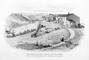
In 1860, an important meeting happened at Lowbands Farm. This meeting helped start the Co-operative Wholesale Society. The farm was a good meeting spot for people from Rochdale, Oldham, and Manchester. It was a nice place to stop during a country walk.
Jumbo is now part of Middleton. It sits between Middleton and Middleton Junction. In 1860, Jumbo was a small village. It had a few farms and cottages where people wove silk by hand. But the area was starting to change after the railway was built.
In 1851, some velvet waistcoat makers decided to try farming. They put their money together to rent six acres of land with a house in Jumbo. The farm was nicknamed "Lowbands."
The farm did not make money. A man named George Booth was put in charge to fix things. A Jumbo Co-operative Society was formed to help out. The farm's loomhouse became the new society's store room. But debts grew, and the farm had to sell its tools in 1861. The remaining goods were sold to the Middleton Society.
Places of Worship
- St Gabriel, Middleton Junction is an Anglo-Catholic Church. It was founded in 1885.
- Jumbo Methodist Church was on Grimshaw Lane. It started in 1868 and closed in 1967.
- Grimshaw Lane, Wesleyan Methodist was founded in 1874. It closed in 1966. In its early years, it was known as Lane End Church.
Middleton Junction County Primary School
Meetings for Methodists in the area began in 1800. In 1820, the Lane End or Hillock Sunday School was built. It was at the corner of Foxdenton and Grimshaw Lanes. As Middleton Junction grew with the railway, a new school was needed. This new school opened in 1874 as Middleton Junction Wesleyan School. The Chadderton School Board took it over in 1894. The school closed in 1968.
Transport Links
Several bus services connect Middleton Junction to other places:
- Stagecoach Manchester runs services 112/113. These go to Middleton and to Manchester City Centre. They pass through Moston and Collyhurst.
- Service 294 offers two early morning trips to the Trafford Centre. These go via Moston, Cheetham Hill, and Salford Quays.
- First Greater Manchester operates service 415. This bus goes to Middleton via Alkrington. It also goes to Lees via Nimble Nook, Cowhill, and Oldham.
- Manchester Community Transport operates service 159. This service goes to Middleton via Tonge. It also goes to Oldham via New Moston, Failsworth, and Chadderton.


