
Milagra Ridge facts for kids
Quick facts for kids Milagra Ridge |
|||||||||||||||||||
|---|---|---|---|---|---|---|---|---|---|---|---|---|---|---|---|---|---|---|---|
.jpg)
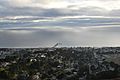
Ruins of Battery 244 overlooking Pacifica at Milagra Ridge
|
|||||||||||||||||||
| Lua error in Module:Location_map at line 420: attempt to index field 'wikibase' (a nil value). | |||||||||||||||||||
| Nearest city | between Daly City and Pacifica | ||||||||||||||||||
| Area | 275 acres (111 ha) | ||||||||||||||||||
| Created | 1987 | ||||||||||||||||||
| Operated by | National Park Service | ||||||||||||||||||
|
|||||||||||||||||||

Milagra Ridge is a 275-acre park with wide-open spaces. It's like a special "island" of nature, even though it's on land! This park is located about 7 miles south of San Francisco. You can find it between the cities of Pacifica and Daly City. Long ago, the Ohlone people lived here. Later, Spanish settlers and Mexican ranchers also called this area home.
Contents
Milagra Ridge: A Look Back in Time
Milagra Ridge has a fascinating past, especially its role in protecting the San Francisco Bay.
Military History: Protecting the Bay
The United States Army bought this land in the late 1930s. It became part of a big defense system for San Francisco Bay. Other defense spots were in San Francisco, Angel Island, and the Marin Headlands.
In 1943, the Army started building Battery Construction No. 244 on Milagra Ridge. This area was then known as the Milagra Ridge Military Reservation. In 1948, two large 6-inch guns were moved here. These guns were placed on special mounts that allowed them to shoot far. The battery was no longer needed by 1950. There were plans to build an even bigger gun area with 16-inch guns, but World War II ended before that project started.
The Nike Missile Site
In 1956, a Nike missile site, called SF-51, was built at Milagra Ridge. These missiles were used for defense. In 1958, the site was updated to use the Nike-Hercules system.
Nike missile sites usually had three parts:
- An office area (SF-51A)
- A control area (SF-51C)
- A missile launcher area (SF-51L)
The office and launcher areas were on Milagra Ridge. The control area was nearby in the Sweeney Ridge preserve.
Changes and Challenges
In 1961, the city of Pacifica thought about using the old Battery 244 bunker. They considered making it a police station and an emergency center. However, they chose a different location in 1969 because it was hard to get to the bunker.
In 1970, Pacifica did lease some of the underground space to the county for storing records. But in 1971, some students entered the bunker and caused a fire. Another fire happened in 1972. After these events, officials stopped using the bunker.
Becoming a Park
The National Guard managed the Nike missile site from 1963 until March 1974. After that, the land was given to the City of Pacifica in May 1974. Some parts of the land had already been transferred earlier. For example, 73 acres became residential areas in 1962. Another 36 acres went to the Department of the Interior in 1972, then to Pacifica in 1974. The buildings at the SF-51A site were torn down in 1983, and homes were built there.
In 1987, the National Park Service took over the remaining 240 acres of Milagra Ridge. It became part of the Golden Gate National Recreation Area. Local volunteers have worked hard to help the park's wildlife.
Protecting the Environment
People living in Pacifica's Manor district formed a group called Concerned Manor Residents. In 1995, they successfully stopped a large building project on the lower parts of Milagra Ridge. They agreed to a smaller group of 23 homes instead.
Today, Milagra Ridge is a protected area. It's a great place for hiking! A new path, the Milagra Battery Trail, opened in November 2016. The park now covers 275 acres. In late spring, you can find tiny wild coast strawberries here. There's also poison oak, so be careful!
Milagra Ridge also has a special sensor from the USGS. This sensor is very close to San Francisco and helps provide real-time data about earthquakes to the public.
Special Animals and Plants

Milagra Ridge is home to several important species. These are animals and plants that are either endangered or threatened. This means they are at risk of disappearing forever.
Butterflies of Milagra Ridge
- Mission blue butterfly (Aricia icarioides missionensis): This beautiful butterfly was first seen here in 1992. It relies on certain types of lupine plants for food, like Lupinus albifrons, L. formosus, and L. variicolor.
- San Bruno elfin butterfly (Callophrys mossii bayensis): This small butterfly was discovered at Milagra Ridge in the mid-1980s.
Other Important Animals
- San Francisco garter snake (Thamnophis sirtalis tetrataenia): While this snake hasn't been seen here, the park has suitable places for it to live.
- California red-legged frog (Rana draytonii): Scientists believe these frogs live here because they've found small burrows that look like theirs.
Images for kids
-
The view of Pacifica from the western side of Milagra Ridge

