
Miller Atlas facts for kids
The Miller Atlas, also known as the Lopo Homem-Reineis Atlas, is a beautiful and important old map book from Portugal. It was made in 1519 and has twelve detailed maps inside.
This amazing atlas was created by several talented mapmakers: Lopo Homem, Pedro Reinel, and Jorge Reinel. An artist named António de Holanda added all the wonderful pictures and decorations.
The maps in the Miller Atlas show many parts of the world known at that time. These include the North Atlantic Ocean, parts of Northern Europe, the Azores islands, Madagascar, the Horn of Africa, the Indian Ocean, Indonesia, the China Sea, the Moluccas (also known as the Spice Islands), Brazil, and the Mediterranean Sea.
The atlas got its name because a librarian named Bénigne Emmanuel Clement Miller bought it in 1855 in Portugal. Later, in 1897, his wife sold it to the National Library of France in Paris, where it is kept today.


Contents
What Makes the Miller Atlas Special?
One of the most interesting parts of the Miller Atlas is its map of "Terra Brasilis," which means "Land of Brazil." This map was drawn less than twenty years after the Portuguese explorer Pedro Álvares Cabral first landed in Brazil. It shows great detail for that time.
Many people believe that King Manuel I of Portugal gave this atlas as a gift to King Francis I of France. It was a very valuable and impressive gift!
A Map and a Mystery
The maps in the atlas, and who made them, caused some big discussions among experts. One world map in particular, which seemed to show the Pacific Ocean as a closed sea, was very interesting. Some people think it might have been a clever way to try and stop Ferdinand Magellan from sailing around the world. Magellan was preparing his famous journey in Spain at the time, working for King Charles I of Spain.
The Atlas's Secret Message
The first page of the Miller Atlas has a special message written on it later. It includes the family symbol of Catherine de Medici, a powerful queen. The message says, in Latin, that Lopo Homem, the mapmaker, created this map of the known world in 1519 in Lisbon, Portugal. He made it for King Manuel I, using many old and new maps, with great care and hard work.
Images for kids
-
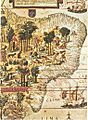
The "Terra Brasilis" map from the Miller Atlas.
-
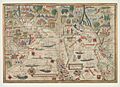
A map of the Indian Ocean from the Miller Atlas.
See also
 In Spanish: Atlas Miller para niños
