
Northern Europe facts for kids

Northern Europe is the northern part of the European continent. It includes many different countries and regions. People often think of Northern Europe in a few different ways.
Some of the main areas usually considered part of Northern Europe are:
- The Nordic countries: These include Denmark, Finland, Iceland, Norway, and Sweden. Also, places like the Åland Islands, the Faroe Islands, and sometimes Karelia and the Kola Peninsula are included.
- The Republic of Ireland and the United Kingdom. This also includes the Isle of Man and the Channel Islands. Sometimes these are also seen as part of Western Europe.
- The Baltic states: These are Estonia, Latvia, and Lithuania.
Other areas sometimes included are those near the Baltic Sea and the North Sea. This can mean parts of northwestern Russia, northern Poland, the Netherlands, Belgium, Luxembourg, and northern Germany.
Europe is the sixth largest continent on Earth. It has 47 countries, plus many islands and territories.
Contents
How Northern Europe Was Defined Over Time
The idea of what "Northern Europe" means has changed a lot through history.
Older Definitions
Before the 19th century, the term 'Nordic' or 'Northern' often meant a larger area. It included the Nordic countries, parts of European Russia, the Baltic countries, and Greenland.
In even older times, the Roman Empire was very powerful around the Mediterranean region. Back then, anything far from the Mediterranean Sea was called Northern Europe. This included places like Germany, the Low Countries, and Austria. During the Middle Ages, people sometimes used the name (Ultima) Thule. This was a semi-mythical place thought to be in the very far north of the continent.
Northern Europe in the European Union
Today, the European Union (EU) sometimes groups countries into a "Northern" category. This group often includes Denmark, Sweden, Finland, Germany, the UK, Ireland, Austria, Luxembourg, Belgium, Netherlands, Estonia, Latvia, and Lithuania.
Images for kids
-
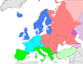
This map shows different parts of Europe. Northern Europe is shown in dark blue.
-
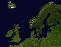
A satellite photo of islands and land around the North Sea and Baltic Sea.
-
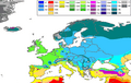
This map shows the different climates in Europe. It uses the Köppen climate classification system.
-
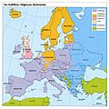
A map of Europe showing the main religions in different regions. Purple is Roman Catholicism, blue is Eastern Orthodox, and green is Islam. Other colors show different types of Protestantism.


See also
 In Spanish: Europa Septentrional para niños
