Milton (CDP), Vermont facts for kids
Quick facts for kids
Milton, Vermont
|
|
|---|---|

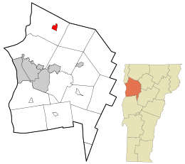
Location in Chittenden County and the state of Vermont.
|
|
| Country | United States |
| State | Vermont |
| County | Chittenden |
| Town | Milton |
| Area | |
| • Total | 1.4 sq mi (3.7 km2) |
| • Land | 1.4 sq mi (3.6 km2) |
| • Water | 0.04 sq mi (0.1 km2) |
| Elevation | 300 ft (90 m) |
| Population
(2020)
|
|
| • Total | 3,804 |
| • Density | 2,660/sq mi (1,028/km2) |
| Time zone | UTC-5 (Eastern (EST)) |
| • Summer (DST) | UTC-4 (EDT) |
| ZIP code |
05468
|
| Area code(s) | 802 |
| FIPS code | 50-45175 |
Milton is a community located within the larger town of Milton in Chittenden County, Vermont, United States. It used to be an official village. In 2003, it changed its status. Now, it is a census-designated place (CDP). This means it's an area identified by the U.S. Census Bureau for collecting statistics. As of the 2020 census, about 3,804 people lived in Milton. The entire town of Milton has a population of 10,723 people.
Contents
Exploring Milton's Location
Milton is found in the eastern part of the town of Milton. It sits along the Lamoille River. This river flows out of Arrowhead Mountain Lake. The river drops about 100 feet over rocky ledges in the western part of the community.
How to Get Around Milton
U.S. Route 7 is a main road that goes right through the center of Milton. If you head north on this road, you will travel about 13 miles to St. Albans. If you go south, you will reach Burlington in about 16 miles.
Milton's Size and Water Areas
The United States Census Bureau measures the size of places. They say that the Milton CDP covers a total area of about 3.7 square kilometers (1.4 square miles). Most of this area, about 3.6 square kilometers (1.4 square miles), is land. A small part, about 0.1 square kilometers (0.04 square miles), is water. This means about 2.90% of Milton is covered by water.
Who Lives in Milton?
The census helps us learn about the people living in a place. In 2000, there were 1,537 people living in Milton. These people lived in 570 households, and 421 of these were families.
Diversity in Milton
Milton is home to people from many different backgrounds. In 2000, most residents, about 97.53%, were White. Other groups included African American (0.33%), Native American (0.39%), and Asian (0.72%). Some people identified with two or more racial backgrounds (0.85%). About 0.59% of the population identified as Hispanic or Latino.
Households and Families
Out of the 570 households, about 39.8% had children under 18 living with them. More than half, 58.2%, were married couples living together. About 11.9% of households had a female head with no husband present. Around 26.1% were non-family households. About 20.5% of all households were single individuals. About 6.8% of these individuals were 65 years old or older. The average household had 2.70 people, and the average family had 3.12 people.
Age Groups in Milton
The population in Milton includes people of all ages. About 29.1% of residents were under 18 years old. About 6.1% were between 18 and 24. The largest group, 34.1%, was between 25 and 44 years old. People aged 45 to 64 made up 22.3% of the population. Finally, about 8.3% of residents were 65 years old or older. The average age in Milton was 35 years. For every 100 females, there were about 100.7 males.
Income and Economy
In 2000, the average income for a household in Milton was $46,458 per year. For families, the average income was $48,882 per year. Males earned an average of $34,792, while females earned $26,548. The average income per person in the village was $18,037. About 6.5% of families and 6.5% of the total population lived below the poverty line. This included 9.0% of those under 18 and 6.9% of those 65 or older.
See also
 In Spanish: Milton (condado de Chittenden) para niños
 | Audre Lorde |
 | John Berry Meachum |
 | Ferdinand Lee Barnett |

