Moa Island (Queensland) facts for kids
|
Banks Island
|
|
|---|---|
 |
|

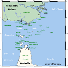
A map of the Torres Strait Islands showing Moa in the northern central waters of Torres Strait
|
|
| Geography | |
| Location | Banks Channel, Northern Australia |
| Coordinates | 10°10′59″S 142°16′01″E / 10.183°S 142.267°E |
| Archipelago | Torres Strait Islands |
| Adjacent bodies of water | Torres Strait |
| Total islands | 1 |
| Administration | |
|
Australia
|
|
| State | Queensland |
| Local government area | Torres Strait Island Region |
| Demographics | |
| Ethnic groups | Torres Strait Islanders |
| Moa Island Queensland |
|||||||||||||||
|---|---|---|---|---|---|---|---|---|---|---|---|---|---|---|---|
| Population | 432 (2021 census) | ||||||||||||||
| • Density | 2.538/km2 (6.57/sq mi) | ||||||||||||||
| Postcode(s) | 4875 | ||||||||||||||
| Area | 170.2 km2 (65.7 sq mi) | ||||||||||||||
| Time zone | AEST (UTC+10:00) | ||||||||||||||
| LGA(s) | Torres Strait Island Region | ||||||||||||||
| State electorate(s) | Cook | ||||||||||||||
| Federal Division(s) | Leichhardt | ||||||||||||||
|
|||||||||||||||
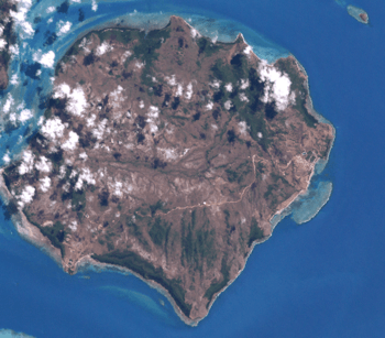
Moa Island, also known as Banks Island, is a special place in the Torres Strait Islands. It's located about 40 kilometers (25 miles) north of Thursday Island in a waterway called Banks Channel, in Queensland, Australia. It's also a recognized area within the Torres Strait Island Region local government.
Moa Island is the largest island in the "Near Western" group of the Torres Strait. It has two main towns: Kubin on the south-west coast and St Pauls on the east coast. These towns are connected by both paved and gravel roads. In 2021, Moa Island was home to 432 people.
Contents
- Discover Moa Island: Geography and Communities
- A Look Back: Moa Island's History
- Moa Island Today: People and Culture
- See also
Discover Moa Island: Geography and Communities
Moa Island is the second largest island in the entire Torres Strait, part of the western island group. It's a vibrant place with two main communities:
- Kubin community: Located on the southern side of the island.
- St Paul's community: Found on the eastern side.
These two communities are linked by a road, making it easy for people to travel between them.
A Look Back: Moa Island's History
The Mualgal people are the traditional owners of Moa Island. They have lived here for a very long time and call the island 'Mua' or Moa. They traditionally had two groups: the southern Italgal and the northern Mualgal.
Early European Visits and Industries
In 1792, Captain William Bligh (yes, the famous one from the Bounty story!) explored the Torres Strait and mapped its reefs and channels. He named the island Banks Island to honor his friend, the botanist Sir Joseph Banks.
Later, in the 1860s, boats came to the Torres Strait looking for valuable sea creatures like beche-de-mer (sea cucumber) and pearls. These industries grew, and by the 1870s, European boats were very active around Moa and Badu Islands. They often hired local Islander men to work on their boats. A small pearling station was even set up on Moa Island between 1872 and 1875.
Queensland Government's Role
In 1872, the Queensland Government wanted more control over the islands. The British Government agreed, extending Queensland's boundary to include all islands within 60 nautical miles of the coast. This boundary was expanded even further in 1879 to include islands like Boigu, Erub, Mer, and Saibai. This allowed the Queensland Government to manage the pearling and beche-de-mer industries more effectively.
The "Coming of the Light"
Torres Strait Islanders remember July 1871 as "the Coming of the Light." This is when missionaries from the London Missionary Society (LMS) first arrived. Reverend A W Murray and William Wyatt Gill visited Moa Island in October 1872. Soon after, South Sea Islander teachers were sent to the island to establish a mission settlement at a place called Totalai. However, this settlement was later abandoned by 1901.
New Settlements and "Company Boats"
In the early 1900s, a new settlement called Adam was started on the western side of Moa Island. People from Totalai and Dabu villages moved there, led by Elder Abu Namai. Adam was closer to Badu Island, which had a school and stores run by a group called Papuan Industries Limited (PIL).
PIL was a special business idea by LMS missionary Reverend Walker. It aimed to help Islanders become more independent by encouraging them to own their own pearl luggers, or "company boats." These boats were used to collect pearl shells and beche-de-mer, which PIL would then sell. The Queensland Government supported this idea. The company boats not only provided income but also boosted community pride and improved travel and communication between the islands. The community at Adam had their own company boats, including the Moa and the Adam. Many men from Moa also worked with pearling crews from Badu.
St. Paul's Mission and South Sea Islanders
In 1904, the Australian Government introduced strict immigration rules, which meant many Pacific Islander workers had to return to their home countries. However, the Queensland Government set aside land on Moa's eastern shore as an Aboriginal reserve for those who had married Torres Strait Islander and Aboriginal people.
In 1908, the Anglican Church began developing St. Paul's Mission on this reserve land. It was named St Pauls after the famous St Paul's Cathedral in London. Deaconess Florence Griffiths Buchanan was a missionary teacher who ran the mission. She was much loved by the children, who called her "Teashher" (teacher).
The mission aimed to be self-supporting through farming, fishing, and weaving. By 1912, there were 70 people at the settlement, and the Queensland Government began providing financial help for education. The mission even had its own boat, the Bengal, for travel between Thursday Island and Moa.
Changes and Challenges
In November 1912, a large area of 36,000 acres on Moa Island was officially made an Aboriginal reserve by the Queensland Government, separate from the land for South Sea Islanders. Many other Torres Strait Islands were also declared reserves around this time. In 1922, the settlement at Adam was renamed Poid.
During the 1920s and 1930s, strict racial laws were applied to Torres Strait Islanders, allowing the government to move Islanders to reserves and missions across Queensland.
Forced Relocation of Kaurareg People
In the early 1920s, the Queensland Government decided to move the Kaurareg people from Hammond Island. They said it was because being too close to Thursday Island caused problems. In March 1922, the Kaurareg community was forcibly moved by government officials from Hammond Island to Poid on Moa Island. Some who protested were even arrested.
The 1936 Torres Strait Islander Strike
In 1936, about 70% of the Torres Strait Islander workforce went on strike. This was a huge moment – the first organized challenge against government control by Torres Strait Islanders. The strike lasted nine months and showed how angry Islanders were about the government controlling their lives, wages, and trade. They also wanted an end to evening curfews, freedom to travel between islands, and the right to choose their own boat crews.
This strike led to important changes. An unpopular local official was replaced by Cornelius O'Leary, who started regular meetings with elected Islander council representatives. These new island councils were given some power, including control over local police and courts.
In 1937, O'Leary held the first Inter Islander Councillors' Conference at Yorke Island, where representatives from 14 communities attended. Wees Nawie and Sailor represented Poid. They discussed and agreed to cancel unpopular rules like curfews and create a new system of local representation. In 1939, the Queensland Government passed the Torres Strait Islanders Act 1939, which included many of these recommendations. A key part of this new law officially recognized Torres Strait Islanders as a separate people from Aboriginal Australians.
Moving to Kubin
During the 1920s and 1930s, the settlement at Poid faced health problems like malaria and dengue fever, and often ran out of fresh water. So, in 1943, the community at Poid decided to move to a new location called Kubin, on the south-west coast of Moa Island. Kubin had fresh water springs and was thought to be a much healthier place. By 1945, a church and school were built at Kubin, and everyone from Poid had moved there.
Moa Island During World War Two
During World War II, the Australian Government recruited Torres Strait Islander men to join the armed forces. Men from Moa and other islands formed the Torres Strait Light Infantry Battalion. Even though they were respected soldiers, they only received one-third of the pay given to white Australian servicemen. On 31 December 1943, members of the Torres Strait Light Infantry went on strike, demanding equal pay and equal rights. The Australian Government agreed to increase their pay to two-thirds of what white servicemen received. Years later, in the 1980s, the government offered full back pay to these servicemen.
Mining and Co-operatives
The mineral wolfram was found on Moa Island in the 1930s, and people from Kubin and St Pauls began mining it in 1938. In the 1950s and 1960s, Reverend Alf Clint set up a Christian co-operative that ran mining operations on the island. However, all mining stopped in 1973 when the price of wolfram dropped.
The Torres Strait Treaty
After Papua New Guinea became independent from Australia in 1975, there were discussions about the borders in the Torres Strait. In 1978, Australia and Papua New Guinea signed the Torres Strait Treaty. This treaty, which started in 1985, set the boundaries between the two countries and allowed for special free movement (without passports or visas) between communities for traditional activities like fishing, trading, and family gatherings in a special "Protected Zone." This zone also helps protect the land, sea, air, and wildlife of the Torres Strait.
Education Changes
St Pauls State School opened on 29 January 1985. On 1 January 2017, it became the St Pauls Campus of the Tagai State College, which has 17 campuses across the Torres Strait.
Moa Island Today: People and Culture
Population and Demographics
In 2016, Moa Island had a population of 448 people. By 2021, the population was 432 people.
Cultural Groups
Kubin is a diverse community. It's mainly made up of the original Italgal people, the Mualgal from northern Moa, some of the Kulkalgal from Nagi, and the Kaiwalgal (Kaurareg) people. The Kaurareg were moved to Poid in 1921. After World War II, Poid was abandoned. Some Kaurareg moved back to their homeland on Narupai (Horn Island), while others moved to Kubin to be closer to their homeland, led by Wees Nawia.
Local Government
On 30 March 1985, the Kubin community elected three councillors to form the Kubin Island Council. This council then took over the land, which was previously an Aboriginal reserve managed by the Queensland Government.
In 2007, a reform recommended that the 15 Torres Strait Island councils be replaced by one larger council, the Torres Strait Island Regional Council (TSIRC). The first TSIRC was elected on 15 March 2008.
Languages Spoken
The main language spoken in Kubin is Kala Lagaw Ya (specifically the Muwalgau/Italgau and Kaiwalgau sub-dialects). In St. Pauls, the main language is Brokan (Torres Strait Creole). Many people on the island are bilingual, meaning they can speak both languages.
Education on Moa Island
Moa Island has two primary school campuses, both part of Tagai State College:
- St Pauls Campus: This primary school (Early Childhood to Year 6) is located at 10 Anu Namai Road.
- Kubin Campus: This primary school (Early Childhood to Year 6) is located at Kanaian Yabu.
There is no secondary school on Moa Island. Students who want to continue their education in Years 7-12 usually attend the secondary campus of Tagai State College on Thursday Island.
See also
 | Stephanie Wilson |
 | Charles Bolden |
 | Ronald McNair |
 | Frederick D. Gregory |

