Mocho-Choshuenco facts for kids
Quick facts for kids Mocho-Choshuenco |
|
|---|---|

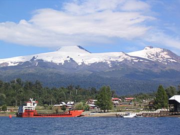
In the left; the Mocho cone and in the right the eroded Choshuenco. Puerto Fui at Pirihueico Lake in the foreground.
|
|
| Highest point | |
| Elevation | 2415 m (Choshuenco) 2422 m (Mocho) |
| Listing | Ultra |
| Naming | |
| Language of name | Spanish for headless (Mocho) and Mapudungun for yellow waters (Choshuenco) |
| Pronunciation | Spanish: [ˈmotʃo tʃosˈweŋko] |
| Geography | |
| Location | Panguipulli, Futrono and Los Lagos, Chile |
| Parent range | Andes |
| Geology | |
| Mountain type | Stratovolcano |
| Volcanic arc/belt | South Volcanic Zone |
| Last eruption | 1937 |
| Climbing | |
| First ascent | 1934 Dr. Rudolf Haege, Kaerner and Steenbloock (Choshuenco) |
| Easiest route | Choshuenco (nearest village with provisions) – Enco – Río Blanco – Tumba del Buey – Mochos peak – Choshuencos peak (in that order) |
Mocho-Choshuenco (say it: MOTCH-oh choss-WEN-koh) is a huge volcano in the Andes mountains of Chile. It's covered in glaciers and is actually made of two volcanoes joined together! These are called Choshuenco and Mocho.
Choshuenco is the older part, found in the northwest. It has a crater that has been worn away over time. Mocho is a newer volcano that sits on top of an older, sunken area called a caldera. Around Mocho, there are smaller volcanic hills called cinder cones.
The highest parts of Mocho-Choshuenco are protected in the Mocho-Choshuenco National Reserve. Some of its eastern slopes are also part of the Huilo-Huilo Natural Reserve.
Many rivers and lakes surround the northern part of Mocho-Choshuenco. These include the Fui, Enco, and Llanquihue rivers, and the Pirihueico, Panguipulli, and Riñihue lakes. Sometimes, the Fui River's water goes underground, which can make the Huilo-Huilo Falls dry up.
What's in a Name?
The two volcanoes have had many names throughout history. For example, in 1795, one was called Valdivia. Later, in 1875, people used the names Panguipulli and Lajara for Choshuenco and Mocho. This was because only Choshuenco could be seen from Panguipulli Lake.
The name Mocho comes from a Spanish word meaning "short cut" or "headless." This describes Mocho's flat-topped shape. The name Choshuenco comes from the Mapudungun language, spoken by the Mapuche people. It might mean "yellow earth and water" or "place where there is water to dye yellow."
Volcano Eruptions
Scientists don't know much about eruptions from Mocho-Choshuenco before about 10,000 years ago. This is because a huge ice sheet covered the Andes mountains back then. The ice would have hidden or moved any ash and rocks from eruptions.
About 10,300 years ago, Choshuenco had a very powerful eruption. It created a lot of light, spongy rock called pumice.
The first written records of eruptions from Mocho-Choshuenco are from the 1600s. A map from 1646 might show it erupting. Another map from 1795 clearly shows it erupting, probably referring to an eruption in 1759.
On November 1, 1864, a small cinder cone named Chaiquemahuida erupted. This eruption caused fast-moving flows of hot gas and rock. People living nearby felt a strong noise and an earthquake.
The last reported eruption was on June 16, 1936. Not much is known about it, but it might have caused mudslides. Some experts think this report might not be accurate, like a similar report for another volcano in 1906.
Glaciers on the Volcano
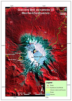
The very top of Mocho-Choshuenco is covered by a large ice cap. This ice cap covers the Mocho cone and parts of Choshuenco.
However, this ice cap has been shrinking. Between 1976 and 2003, it lost 40% of its total area. The biggest loss of ice happened on the Choshuenco Glacier. The Mocho Glacier is still the largest, covering about 5.1 square kilometers.
See also
 In Spanish: Volcán Mocho-Choshuenco para niños
- Geology of Valdivia
- Glaciers of Chile
- List of volcanoes in Chile
 | Anna J. Cooper |
 | Mary McLeod Bethune |
 | Lillie Mae Bradford |


