
Moffat Beach, Queensland facts for kids
Quick facts for kids Moffat BeachCaloundra, Queensland |
|||||||||||||||
|---|---|---|---|---|---|---|---|---|---|---|---|---|---|---|---|

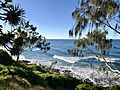
Views from Moffat Head, 2018
|
|||||||||||||||

Moffat Beach
Location in Queensland
|
|||||||||||||||
| Population | 2,691 (2021 census) | ||||||||||||||
| • Density | 1,920/km2 (5,000/sq mi) | ||||||||||||||
| Postcode(s) | 4551 | ||||||||||||||
| Area | 1.4 km2 (0.5 sq mi) | ||||||||||||||
| Time zone | AEST (UTC+10:00) | ||||||||||||||
| Location | |||||||||||||||
| LGA(s) | Sunshine Coast Region | ||||||||||||||
| County | Canning | ||||||||||||||
| Parish | Bribie | ||||||||||||||
| State electorate(s) | Caloundra | ||||||||||||||
| Federal Division(s) | Fisher | ||||||||||||||
|
|||||||||||||||
Moffat Beach is a lovely coastal area located in the Sunshine Coast Region of Queensland, Australia. It's a popular spot with a population of about 2,691 people as of 2021.
Contents
About Moffat Beach
Moffat Beach is part of the larger Caloundra area. You can find it just north-east of the main part of Caloundra.
A Look Back in Time
How Moffat Beach Got Its Name
Moffat Beach got its name from James Campbell Moffat. He was a chemist from Brisbane who bought land here way back in 1882. A year later, he built a holiday home nearby. The headland (a rocky point of land) is also named after him.
The Queen of the Colonies Shipwreck
There's a special story about a tree called the Queen of the Colonies pandanus tree. It stood on the headland where 13 passengers from a shipwreck came ashore. This happened in April 1863 during a big storm. They were returning from Moreton Island when their ship, the Queen of the Colonies, was wrecked. In 1963, a concrete memorial was put up to remember this event.
Early Guesthouse
In 1888, Caloundra's first guesthouse, "Sea Glint," opened. It was built on a ridge overlooking what is now Moffat Beach. Even important people like Sir Thomas McIlwraith, who was the Premier of Queensland, used to visit Sea Glint often.
Shopping and Eating
Moffat Beach has some great places to visit. On Buccleugh Street, you can find a bakery, a convenience store, doctors' offices, and a post office.
If you're looking for food or gifts, head to Seaview Terrace and Roderick Street. There are cafes, restaurants, and takeaway shops. You can also find gift shops, an art gallery, and even a craft brewery there.
Parks and Fun Activities
Eleanor Shipley Park
Eleanor Shipley Park is a large park that stretches from Tooway Lake all the way to the cafes on Seaview Terrace. It's a great place for a picnic, with barbecue areas and shelters. Kids can enjoy the play area, and it's easy to get to Moffat Beach from here.
Roslin Park
Roslin Park, on Roslin Street, also has a play area for children. This park is also friendly for dogs.
Moffat Beach Rules for Dogs
On Moffat Beach, dogs are allowed to run around without a leash before 8 AM and after 4 PM. It's important to know that there are no lifeguards patrolling this beach.
Des Dywer Walking Track
The Des Dywer walking track is a beautiful path that follows the coastline. It goes from Moffat Beach all the way to Bulcock Beach. You'll walk along cliffs and boardwalks, enjoying the ocean views.
Surfing at Moffat Beach
Moffat Beach is a famous spot for surfing. The Moffat Headland protects the beach from strong southerly winds. This creates a perfect "surf break" where waves are just right for surfing.
Pa and Ma Bendall Surfing Classic
One of Australia's oldest surfing competitions is held here every Easter. It's called the Pa and Ma Bendall Surfing Classic. This event honors two local surfing legends, Charles "Pa" Bendall and Marjorie "Ma" Bendall.
Images for kids
-
Views from Moffat Head, 2018
