
Mollys Castle facts for kids
Quick facts for kids Mollys Castle |
|
|---|---|

Mollys Castle
|
|
| Highest point | |
| Elevation | 5,265 ft (1,605 m) |
| Prominence | 365 ft (111 m) |
| Isolation | 2.08 mi (3.35 km) |
| Parent peak | Wild Horse Butte (5,760 ft} |
| Geography | |

Mollys Castle
Location in Utah

Mollys Castle
Location in the United States
|
|
| Location | Emery County, Utah, U.S. |
| Parent range | Colorado Plateau |
| Topo map | USGS Goblin Valley |
| Geology | |
| Age of rock | Jurassic |
| Type of rock | sandstone |
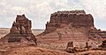
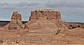
Mollys Castle is a tall, natural rock formation in Emery County, Utah. It stands 5,265 feet (about 1,605 meters) high. This amazing peak is located near Goblin Valley State Park.
Mollys Castle is a type of landform called a butte. A butte is a tall, flat-topped hill with steep sides. It rises about 265 feet above the land around it. Water from rain and snow that falls on Mollys Castle eventually flows into the Colorado River.
Contents
Exploring Mollys Castle and Its Surroundings
Mollys Castle is found in a quiet area called the San Rafael Desert. This desert is on the edge of the San Rafael Swell, which is a large, dome-shaped uplift in the Earth's crust. The castle is about 2.3 miles (3.7 km) east of Wild Horse Butte. It is also just half a mile outside the eastern border of Goblin Valley State Park.
How Mollys Castle Was Formed
Mollys Castle is a very old rock formation made of Jurassic rock. This means it formed during the Jurassic period, millions of years ago. It is an "erosional remnant," which means it's what's left after wind and water wore away the softer rock around it.
The top layer of Mollys Castle is a light-colored rock called Curtis Formation caprock. This hard caprock protects the softer rock below it. Underneath, you'll find darker, reddish Entrada Sandstone. This same sandstone forms the strange, mushroom-shaped rocks called hoodoos that give Goblin Valley its name.
Weather Around Mollys Castle
The best times to visit Mollys Castle are in the spring and fall. The area has a Cold semi-arid climate. This means it's a dry place, like a desert, but it can get quite cold in winter.
The coldest month usually has an average temperature below 32°F (0°C). Most of the yearly rain falls during spring and summer. This desert area gets less than 10 inches (254 mm) of rain each year. Snowfall in winter is usually light.
Gallery
-
Mollys Castle in the desert landscape
-
Another view of Mollys Castle


