Wild Horse Butte facts for kids
Quick facts for kids Wild Horse Butte |
|
|---|---|

Wild Horse Butte
|
|
| Highest point | |
| Elevation | 5,760 ft (1,760 m) |
| Prominence | 760 ft (230 m) |
| Isolation | 3.84 mi (6.18 km) |
| Parent peak | Point 6260 |
| Geography | |

Wild Horse Butte
Location in Utah

Wild Horse Butte
Location in the United States
|
|
| Location | Goblin Valley State Park Emery County, Utah, U.S. |
| Parent range | Colorado Plateau |
| Topo map | USGS Goblin Valley |
| Geology | |
| Age of rock | Jurassic |
| Type of rock | shale, siltstone, sandstone |
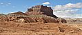
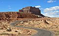
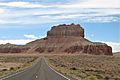
Wild Horse Butte is a tall mountain peak, standing 5,760 feet (about 1,756 meters) high. You can find it in Goblin Valley State Park in Emery County, Utah. This impressive rock formation is about 2.3 miles (3.7 kilometers) west of another cool spot called Mollys Castle. It rises more than 800 feet (244 meters) above the land around it! Rain and snow that fall on Wild Horse Butte eventually flow into the mighty Colorado River.
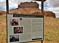
In January 1854, an explorer named John C. Frémont and his team stopped at Wild Horse Butte during their fifth expedition. A photographer with them, Solomon Nunes Carvalho, even took a very early type of photograph, called a daguerreotype, of the butte.
Contents
What is Wild Horse Butte Made Of?
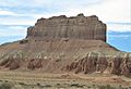
This amazing butte is located in the San Rafael Desert, right on the edge of the San Rafael Swell. Wild Horse Butte is made up of four different layers of rock, all from the Jurassic period.
Top Rock Layers
The very top layer is called the Morrison Formation. This type of rock is famous because many dinosaur bones have been found in it! While no dinosaur bones have been reported on Wild Horse Butte itself, they have been discovered in the Morrison Formation nearby.
Below the Morrison Formation is the Summerville Formation. This layer forms cliffs and has thin beds of shale, siltstone, and sandstone. You can also find thin layers of gypsum here, which suggests that the area used to be very dry, with shallow pools of water that would evaporate easily.
Lower Rock Layers
Underneath the Summerville Formation is the Curtis Formation. This layer is lighter in color and forms slopes.
The very bottom layer is a dark, reddish rock called Entrada Sandstone. This is the same type of rock that makes up the unique mushroom-shaped hoodoos that give Goblin Valley its name!
Weather at Wild Horse Butte
The best times to visit Wild Horse Butte are during spring and fall. The area has a Cold semi-arid climate, which means it's a desert climate but can get quite cold in winter. The coldest month usually has an average temperature below 32°F (0°C). Most of the rain and snow falls during spring and summer.
This desert area gets less than 10 inches (254 millimeters) of rain each year. Snowfall in the winter is usually light.
Images for kids
-
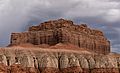
Top to bottom: Morrison Formation, Summerville, Curtis, Entrada Sandstone.
-
-
-
-
-