
Molokai facts for kids
|
Nickname: The Friendly Isle, ʻĀina Momona
|
|
|---|---|

Satellite image of Molokai
|
|

Location in the state of Hawaiʻi
|
|
| Geography | |
| Coordinates | 21°08′06″N 157°00′36″W / 21.13500°N 157.01000°W |
| Area | 260 sq mi (670 km2) |
| Area rank | 5th largest Hawaiian Island |
| Highest elevation | 4,961 ft (1,512.1 m) |
| Highest point | Kamakou |
| Administration | |
| Symbols | |
| Flower | Kukui |
| Color | ʻŌmaʻomaʻo (green) |
| Largest settlement | Kaunakakai |
| Demographics | |
| Demonym | Molokaian |
| Population | 7,345 |
| Pop. density | 28 /sq mi (10.8 /km2) |
Molokai (which is pronounced like "moh-loh-KAI") is one of the eight main Hawaiian Islands. It sits in the middle of the Pacific Ocean. It is the fifth largest island in Hawaii.
Molokai is about 38 miles (61 km) long and 10 miles (16 km) wide. It has a land area of about 260 square miles (670 km²). This makes it the 27th largest island in the United States. Molokai is southeast of Oahu and north of Lanai. You can see Oahu, Lanai, and Maui from Molokai's shores.
The island's economy used to rely on cattle, pineapple, and sugarcane farming. Tourism is a small part of the economy. Many tourist places closed in the early 2000s. This happened when Molokai Ranch, a big landowner, stopped its operations.
On the north coast, in Kalawao County, there was a special settlement. From 1866 to 1969, people with leprosy were cared for there. Today, the Kalaupapa National Historical Park protects this important area.
Contents
Island Names and Meanings
Molokai is known by several special names to local people. These names show how important the island is.
- Molokaʻi ʻĀina Momona means "land of abundance."
- Molokaʻi Pule Oʻo means "powerful prayer."
- Molokaʻi Nui A Hina means "of the goddess Hina."
You might see the name written as Molokai or Molokaʻi. Both ways have been used for a long time. There is some discussion about which is the original Hawaiian spelling. The United States Geological Survey (USGS) uses the spelling with the ʻokina (ʻ).
Molokai's Geography

Molokai was formed by two large shield volcanoes. These are called East Molokai and West Molokai. The highest point on the island is Kamakou on East Molokai. It stands at 4,970 feet (1,515 meters) tall.
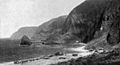
East Molokai volcano is what is left of a much larger mountain. About 1.5 million years ago, the northern part of the mountain collapsed. This created the highest sea cliffs in the world on Molokai. The south shore of Molokai has the longest fringing reef in the U.S. It is almost 25 miles (40 km) long.
Molokai is part of the state of Hawaii. Most of the island is in Maui County, Hawaii. However, the Kalaupapa Peninsula is a separate area called Kalawao County. The biggest town on Molokai is Kaunakakai. It is one of two small ports on the island. Molokai Airport is located in the middle of Molokai.
Molokai is separated from Oahu by the Molokai Channel. It is separated from Maui by the Pailolo Channel. The Kalohi Channel separates it from Lanai.
Molokai's Nature and Wildlife

Molokai has two main types of land. The western part is very dry. Its soil has been damaged because of too much grazing by deer and goats. This area has mostly non-native kiawe trees. One special natural area is the coastal dunes of Moomomi. These dunes are protected by The Nature Conservancy.
The eastern part of Molokai is a high plateau. It rises to 4,900 feet (1,494 meters) at Kamakou peak. This area includes the Molokai Forest Reserve. The eastern half has lush wet forests. These forests get over 300 inches (760 cm) of rain each year.
The high-elevation forests have native ʻōhiʻa lehua trees. They also have many different kinds of plants and animals that are found only there. Much of the top of the mountain is protected by The Nature Conservancy.
Below 4,000 feet (1,219 meters), many non-native plants grow. These include strawberry guava and eucalyptus trees. Introduced axis deer and feral pigs live in the native forests. They damage native plants and spread invasive ones. Near the top of Kamakou is the unique Pēpēʻōpae bog. Here, small ʻōhiʻa trees grow on soggy ground.
Molokai is home to many unique plant and animal species. Sadly, some species have become extinct. These include the olomaʻo bird and the kākāwahie bird. Molokai also has many unique insects, like a special wingless fly.
Molokai's History
,_HI_Light_House_-_Molokai_from_sea_-_Sailing_2011_Puanani_IMG_0769.jpg)
People used to think Molokai was first settled around AD 650. This was by native people likely from the Marquesas Islands. However, new studies show that people from eastern Polynesia arrived much later. They came in two main waves, between 1025 and 1290. Later settlers probably came from Tahiti and other South Pacific islands.
Captain James Cook saw Molokai in 1778. But the first European sailor to visit was Captain George Dixon in 1786. The first big European influence came in 1832. A Protestant mission was started at Kaluaʻaha by the Reverend Harvey Hitchcock.
The first farmer to grow and sell sugar and coffee was Rudolph Wilhelm Meyer. He came from Germany in 1850. In 1878, he built the island's only sugar mill. Today, it is a museum.
Ranching started on Molokai in the early 1800s. King Kamehameha V set up a country estate there. This estate became the Molokai Ranch. In the late 1800s, King Kamehameha V also built a vacation home in Kaunakakai. He ordered over 1,000 coconut trees to be planted in Kapuaiwa Coconut Grove.
The Kalaupapa Settlement
Leprosy (also called Hansen's disease) was one of many diseases brought to Hawaii. Traders, sailors, and workers from other countries brought them. Hawaiian islanders had no natural protection against these new diseases. So, many people got sick and died from diseases like smallpox, cholera, and leprosy.
Sugar plantation owners worried about their workers. They asked the government to control the spread of leprosy. The government passed a law to quarantine people with leprosy. In 1866, they created a settlement for them at Kalawao. This was on the isolated Kalaupapa peninsula on Molokai's north side. Later, Kalaupapa became the main community.

The population of these settlements reached 1,100 people in the early 1900s. Over the years, more than 8,500 people with leprosy were sent to this colony. They were not allowed to leave or have visitors. They had to live out their lives there.
Many brave people helped those living in the settlement. Father Damien de Veuster, a Belgian priest, served there for 16 years. Joseph Dutton, who fought in the American Civil War, came to help Father Damien in 1886. Mother Marianne Cope and six of her Sisters also came to help.
Father Damien and Mother Marianne have been recognized as Saints by the Catholic Church. This is because of their caring work for people with leprosy. Joseph Dutton is also being considered for sainthood.
In the 1920s, a new treatment using chaulmoogra oil was developed by Alice Ball. In the 1940s, new medicines called sulfonamide drugs helped even more. Today, modern medicine can treat leprosy very well. People are no longer contagious after starting treatment.
In 1969, the old laws of forced quarantine were ended. Some former patients chose to stay in Kalaupapa. Today, there are no active cases of leprosy on the island.
Molokai's Economy
Molokai Ranch used to build hotels and resorts for tourists. But the local community fought against this development. They wanted to protect their way of life. There were protests, sometimes violent. For example, fences were cut, and water pipes were destroyed.
In 2007, people started the "Save Laʻau Point" movement. They opposed the Molokai Ranch's plans to expand its resort. Because of this, in 2008, Molokai Ranch closed all its resort operations. This included hotels, a movie theater, and a golf course. About 120 workers lost their jobs. In 2017, the company that owns Molokai Ranch put its 55,575-acre property up for sale. This property covers 35% of Molokai.
Because of the fight against tourism, Molokai has Hawaii's highest unemployment rate. Many residents want to keep their traditional way of life. However, this can be hard, and many families live below the poverty line. About one-third of residents use food stamps. As of 2014, the biggest industry on the island is producing seeds for companies like Monsanto.
Tourism on Molokai


Molokai has a small tourism industry compared to other Hawaiian islands. In 2015, only about 64,767 tourists visited Molokai. For many years, Molokai residents have resisted efforts to increase tourism. They worry about how it might change their community and culture. There are not many places to stay. As of 2014, only one hotel was open. Most tourists stay in rental condos and houses.
National Geographic Traveler magazine and George Washington University study sustainable tourism. In 2007, experts looked at 111 islands around the world. Molokai ranked 10th for its undeveloped nature, care for the environment, and rich Hawaiian traditions. Other Hawaiian islands like Hawaii, Kauai, Maui, and Oahu ranked lower.
Molokai is believed to be the birthplace of the hula dance. The annual Molokaʻi Ka Hula Piko festival is held on the island.
You can reach Molokai by plane. Flights come daily from other Hawaiian islands. These include Oahu, Maui, and Hawaii. A ferry used to run between Molokai and Maui. But it stopped operating in 2016.
Molokai's Infrastructure
Education
Molokai has a public school system. It includes four elementary schools, one charter school, one middle school, and one high school. There is also a community college and one private middle/high school.
Parks and Protected Areas

Molokai has many parks and protected areas. Most parks do not have staff, drinking water, or restrooms. Parks in Maui County include Palaʻau State Park, Kiowea Beach Park, and Papohaku Beach Park. Papohaku Beach Park has a 3-mile (5 km) long beach.
Today, Kalawao County is protected by the Kalaupapa National Historical Park. You can visit this park by guided mule or hiking tour.
Transportation on Molokai
Highways
You can travel across the island on a two-lane highway. It runs from east to west (highways 450 and 460). Highway 470 goes up to the mountains near Kalawao County and the Kalaupapa peninsula. You can only reach Kalaupapa by land using a hiking trail. Mule rides on the trail were stopped in 2018 due to a landslide. Most people get to Kalaupapa by sea.
Bus Service
Maui Economic Opportunity runs public transportation on Molokai.
Notable People from Molokai
- Mother Marianne Cope, a 19th-century nun and saint
- Father Damien de Veuster, a 19th-century Catholic priest and saint
- Joseph Dutton, a Catholic missionary who worked with Father Damien
- Linda Lingle, the 6th Governor of Hawaiʻi
- Rudolph Wilhelm Meyer, a politician and businessman in Hawaiʻi
- Lois-Ann Yamanaka, a poet and novelist
Molokai Royalty
- Nuʻakea, High Chieftess of Molokaʻi
- Hualani, High Chieftess of Molokaʻi
- Keʻoloʻewa, High Chief of Molokaʻi
- Kamauliwahine, Lady of Molokaʻi
- Kanealai, High Chieftess and Queen Regent of Molokaʻi in the 18th century
Towns and Villages
Images for kids
-
Leper colony 1907 on Molokai
-
The Kalaupapa Leper Settlement

See also
 In Spanish: Molokai para niños
