Moncure, North Carolina facts for kids
Quick facts for kids
Moncure, North Carolina
|
|
|---|---|

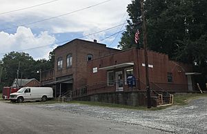
Cluster of old buildings in Moncure; post office on the right
|
|
| Country | United States |
| State | North Carolina |
| County | Chatham |
| Area | |
| • Total | 4.91 sq mi (12.72 km2) |
| • Land | 4.73 sq mi (12.25 km2) |
| • Water | 0.18 sq mi (0.47 km2) |
| Elevation | 223 ft (68 m) |
| Population
(2020)
|
|
| • Total | 780 |
| • Density | 164.90/sq mi (63.67/km2) |
| Time zone | UTC-5 (Eastern (EST)) |
| • Summer (DST) | UTC-4 (EDT) |
| ZIP code |
27559
|
| FIPS code | 37-43880 |
| GNIS feature ID | 2628645 |
Moncure is a small community in Chatham County, North Carolina. It was started in 1881. Moncure and a nearby place called Haywood make up the Moncure census-designated place (CDP). In 2020, about 780 people lived here.
Moncure is located where the Deep River and Haw River meet. These two rivers then form the Cape Fear River. Long ago, Moncure was an important port. Steamships could travel from here all the way to the Atlantic Ocean.
Contents
Moncure's Location and Size
Moncure is in the southeastern part of Chatham County. The Deep River is its southern border. This river also separates Moncure from Lee County.
The Moncure CDP includes the main village of Moncure. It also has a smaller community called Haywood to the east. Both are found along Old US Highway 1. The CDP reaches as far east as the Haw River. It goes south to where the Haw and Deep Rivers join to form the Cape Fear River.
A big highway, U.S. Route 1, goes through Moncure. You can get on it from Exit 79. This highway leads northeast about 28 miles (45 km) to Raleigh. Raleigh is the state capital. It also goes southwest about 12 miles (19 km) to Sanford.
The United States Census Bureau says the Moncure CDP covers about 4.9 square miles (12.8 square kilometers). Most of this area is land, and a small part is water.
Local Landmarks and Industry
The B. Everett Jordan Lake Dam is just north of Moncure. This area is home to some big industries in Chatham County. For example, the Shearon Harris Nuclear Power Plant is about 8 miles (13 km) to the east. There are also several factories that make plywood and lumber.
People Living in Moncure
| Historical population | |||
|---|---|---|---|
| Census | Pop. | %± | |
| 2020 | 780 | — | |
| U.S. Decennial Census | |||
In 2020, the population of Moncure was 780 people.
Community Services and Arts
Moncure has its own post office, which uses ZIP code 27559. There are also two convenience stores.
The Moncure Volunteer Fire Department helps keep the area safe from fires. This department started on May 4, 1966. It has two fire stations. Station 8 is in Moncure on Old US 1. Station 14 is on Corinth Road. The Moncure Fire Department Ladies auxiliary is also very active.
Moncure and the nearby town of Pittsboro have a lively art scene. There used to be a place called the Moncure Museum of Modern Art in Moncure.
Moncure's Beginnings
Moncure was founded in 1881. Four people helped start it: Thomas Jefferson Moncure, Benjamin Gunter Womble, Jake Wisseler, and James Everett Bryan.
Thomas Moncure was an engineer for the Seaboard Air Line Railroad. Benjamin Womble owned the Womble Hotel. He was also the first postmaster of Moncure for 30 years. The old post office building is still on the Womble family's land today.
Two important historical sites in the area are listed on the National Register of Historic Places. These are the Newkirk State (Site 3lCH366) and the Lockville Dam, Canal and Powerhouse.
See also
 In Spanish: Moncure (Carolina del Norte) para niños
 | Bessie Coleman |
 | Spann Watson |
 | Jill E. Brown |
 | Sherman W. White |


