
Monteceneri facts for kids
Quick facts for kids
Monteceneri
|
||
|---|---|---|
 |
||
|
||

Monteceneri
Location in Switzerland

Monteceneri
Location in Canton of Ticino
|
||
| Country | Switzerland | |
| Canton | Ticino | |
| District | Lugano | |
| Area | ||
| • Total | 36.08 km2 (13.93 sq mi) | |
| Elevation | 196 m (643 ft) | |
| Population
(Dec 2020 )
|
||
| • Total | 4,535 | |
| • Density | 125.693/km2 (325.54/sq mi) | |
| Postal code |
6573
|
|
| Localities | Medeglia, Bironico, Camignolo, Rivera and Sigirino | |

Monteceneri is a town, also called a municipality, in the Lugano area of Ticino, a canton in Switzerland. It was formed on November 21, 2010. This happened when five smaller towns joined together. These towns were Medeglia, Bironico, Camignolo, Rivera, and Sigirino. The first person elected to be the mayor was Emilio Filippini. He was the mayor until 2016.
Contents
A Look at Monteceneri's Past
The towns that make up Monteceneri have long histories. Medeglia was first mentioned in records in 1195. Bironico, Camignolo, and Rivera were first mentioned in 1296. Sigirino appeared in records starting in 1335.
The Story of Medeglia

Long ago, in the High Middle Ages, Medeglia was likely part of an old valley community called Carvina. This community eventually came under the control of Lugano. In the early 1500s, Medeglia became part of the Bellinzona area. However, it stayed connected to the Agno church district.
Medeglia became part of the Bironico church area in the 1200s. Later, in 1585, it became a smaller church area. Finally, in 1888, it became its own full church area. The main church, St. Bartholomew, was first mentioned in 1328. Its oldest parts were built in the Romanesque style. It was later fixed up and rebuilt in the 1400s and 1600s.
People in Medeglia used to make a living by raising animals and working in forests. Starting in the 1500s, people from Medeglia and Isone bought forests and pastures in other areas. They also started trading with Bellinzona. In the 1800s, many people left Medeglia because they were poor and there wasn't enough farmland. Most of them moved to Argentina and California. Today, most people who live in Medeglia work outside the town.
The Story of Bironico

Around the year 1000, Bironico was an important center for both government and religion in the Carvina region. This region included the middle and upper Vedeggio valley. In the Early Middle Ages, the bishop of Como had power over the village. Later, the city of Como gained control.
In the late 1200s, a noble family from Como called the Rusca family lived in Bironico. They moved into Bironico Castle in 1328 and owned it until 1416. After the Swiss Confederation took over, Bironico became a local government center. From the 1500s, an inn by the Leguana river bridge was a meeting place for Swiss leaders.
The main church, St. Martin, was first mentioned in 1267.
Historically, the town's economy depended on farming and raising animals in the mountains. In the 1800s, many people left due to poverty and little farmland. Today, Bironico has some businesses. However, most workers travel to jobs in the lower Vedeggio valley, Lugano, and Bellinzona.
The Story of Camignolo
In the Middle Ages, Camignolo was part of the Bironico church area. It was also part of the Valle Carvina community. The Como Cathedral owned a lot of land in the village. By 1348, there was a castle called San Ambrogio in the village. We don't know much about this castle, but it was probably destroyed by the Swiss Confederation in the 1500s.
Camignolo became a smaller church area under Bironico in 1670. Then, in 1809, it became its own full church area. The church of S. Pietro e Paolo was first mentioned in the 1400s. It was rebuilt in 1670 to look as it does today. The chapel of St. Ambrogio was likely built in the 900s. It is famous for its beautiful frescoes (wall paintings) from the 1400s and late Romanesque period. It was fixed up between 1976 and 1979.
The village is still mostly about farming. But some industries have also started there. Like other towns in the valley, many people left in the 1800s because they were poor and there wasn't enough farmland. Camignolo has slowly grown into a small regional center. A secondary school was built there.
The Story of Rivera

The oldest signs of people living in Rivera are old tools and graves from the Iron Age and the Roman times. In the Middle Ages, Rivera was part of the Carvina valley community. In the 1200s, Como Cathedral owned land in Sorencino, which is part of Rivera. From 1678, leaders from the twelve parts of the Swiss Confederation in Ticino met in Casa dei landfogti before going to Lugano.
Rivera was part of the Bironico church area. It became its own independent church area in 1754. The church of S. Spirito was rebuilt between 1779 and 1793.
People in Rivera made their living from farming, especially mountain farming and herding animals. When the Ceneri tunnel was being built from 1872 to 1882, the number of people living there grew a lot. A new road was finished in 1811. The tunnel and a train station also helped a new area develop in the flatter part of the valley. This area is now the northern edge of the larger Lugano city area. The base station for the Monte Tamaro gondola lift opened in Rivera in 1972.
The Story of Sigirino
In the Middle Ages, Sigirino belonged to the Carvina valley community. In a land record from 1296, Como Cathedral was the main landowner in Sigirino. It's possible that Sigirino had some kind of fort or defenses back then.
The Church of St. Andrew was first mentioned in 1296. It was completely rebuilt in the 1500s and fixed up again in the 1700s. After separating from the Bironico church area in 1625, Sigirino had its own church area.
Monteceneri's Location and Land

Monteceneri covers an area of about 37 square kilometers (14.3 square miles). About 8.5% of this land is used for farming. A large part, 77.3%, is covered by forests. About 9% of the land has buildings or roads on it. The rest, 5.2%, is unproductive land like rocky areas. Over the last two decades, the amount of land with buildings has grown, while farmland has decreased.
People in Monteceneri
Monteceneri has a population of about 4,700 people. As of 2013, about 23.8% of the people living there were foreign nationals. The population grew by about 11% between 2010 and 2013. In 2013, for every thousand people, 10.3 babies were born, and 6.7 people passed away.
Also in 2013, children and teenagers (ages 0–19) made up 19.2% of the population. Adults (ages 20–64) were 65.8%, and seniors (over 64 years old) made up 14.9%.
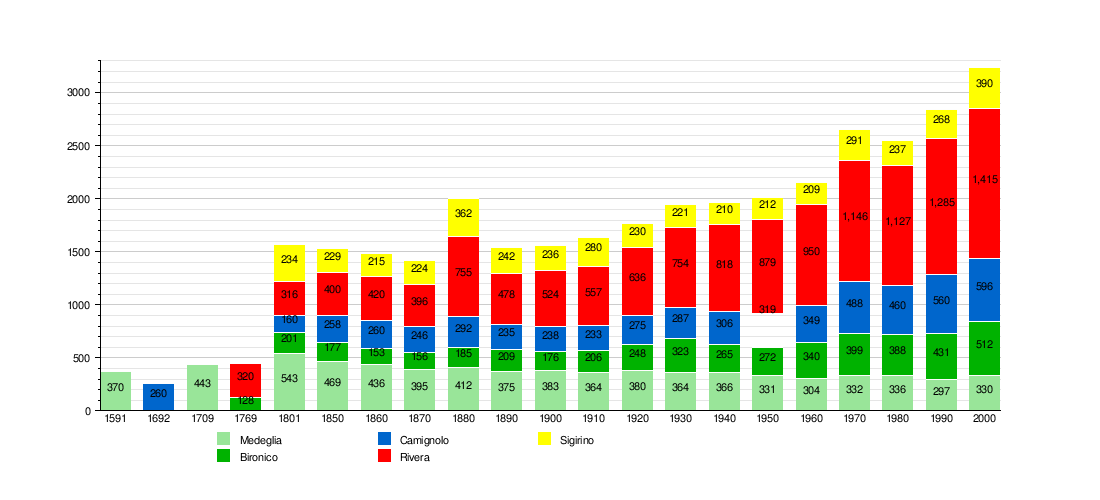
How the Population Has Changed Over Time
The chart below shows how the number of people in each of the five towns changed over many years.
Important Historical Sites

Two places in Monteceneri are very important to Switzerland's history and culture. These are the ruins of the S. Sofia Castle and the Monte Ceneri Radio Station. The entire village of Osignano is also recognized as a special heritage site.
Monteceneri's Economy
In 2012, about 2,119 people worked in Monteceneri. A small number, 26 people, worked in 16 businesses related to farming and natural resources. About 664 people worked in 78 businesses that make things, like factories. The largest group, 1,429 people, worked in 258 businesses that provide services, such as shops or offices. In 2013, about 6.1% of the people in Monteceneri received social help.
Getting Around Monteceneri
Monteceneri has its own train station called Rivera-Bironico. This station is located within the town. It is part of the important Gotthard railway line.
Monteceneri's Climate
Bironico, a part of Monteceneri, has a cool climate with cold winters and mild summers. The average temperature for the whole year is about 10.6°C (51°F). January is usually the coldest month, with an average temperature of 1.7°C (35°F). July is the warmest month, averaging 20.6°C (69°F).
May is the wettest month, getting about 193 mm (7.6 inches) of rain or snow. February is the driest month, with about 64 mm (2.5 inches) of rain or snow.
| Climate data for Bironico | |||||||||||||
|---|---|---|---|---|---|---|---|---|---|---|---|---|---|
| Month | Jan | Feb | Mar | Apr | May | Jun | Jul | Aug | Sep | Oct | Nov | Dec | Year |
| Daily mean °C (°F) | 2 (35) |
4 (39) |
7 (44) |
11 (51) |
15 (59) |
18 (64) |
21 (69) |
20 (68) |
17 (62) |
12 (53) |
7 (44) |
3 (37) |
11 (51) |
| Average precipitation mm (inches) | 69 (2.7) |
64 (2.5) |
110 (4.4) |
150 (6) |
190 (7.6) |
190 (7.3) |
160 (6.3) |
180 (7.1) |
180 (7) |
180 (7.1) |
140 (5.5) |
79 (3.1) |
1,690 (66.4) |
See also
 In Spanish: Monteceneri para niños
