
Bironico facts for kids
Quick facts for kids
Bironico
|
||
|---|---|---|
|
||

Bironico
Location in Switzerland

Bironico
Location in Canton of Ticino
|
||
| Country | Switzerland | |
| Canton | Ticino | |
| District | Lugano | |
| Municipality | Monteceneri | |
| Area | ||
| • Total | 4.18 km2 (1.61 sq mi) | |
| Elevation | 465 m (1,526 ft) | |
| Population | ||
| • Total | 515 | |
| • Density | 123.21/km2 (319.1/sq mi) | |
| Postal code |
6804
|
|
| Surrounded by | Cadenazzo, Camignolo, Medeglia, Rivera | |

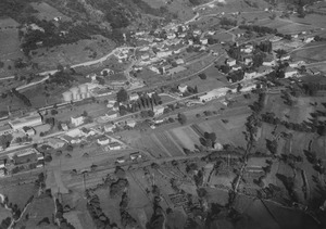
Bironico is a small village located in the northern part of the Lugano area in Ticino, a canton (like a state) in Switzerland. It's nestled in the beautiful Swiss Alps.
In 2010, Bironico joined with several other nearby villages. These included Medeglia, Camignolo, Rivera, and Sigirino. Together, they formed a new, larger municipality called Monteceneri.
Contents
History of Bironico
Bironico was first mentioned in official records way back in 1296. Around the year 1000, it was likely an important center for the Carvina region. This area included the middle and upper parts of the Vedeggio valley.
For a long time, Bironico was under the control of the bishop of Como. Later, the city of Como took over. In the late 1200s, a noble family called the Rusca lived here. They had a castle in Bironico from 1328 to 1416.
Starting in the 1500s, an inn near the Leguana bridge became a meeting spot. Ministers from the Old Swiss Confederacy would gather there. The local church, dedicated to St. Martin, has been around since 1267.
In the past, people in Bironico mostly worked in traditional farming in the mountains. Many also left to find work elsewhere. Today, more people work in trade and industry. However, most residents travel to larger towns like Lugano and Bellinzona for their jobs.
Geography and Landscape
Bironico covers an area of about 4.18 square kilometers (1.6 square miles). A big part of this land, about 77.5%, is covered by forests. About 11.2% is used for farming. The rest is made up of buildings, roads, rivers, and some unproductive land.
Most of the forested land is dense forest. A small part has orchards or groups of trees. For farming, some land is used for crops, some for orchards, and some for mountain pastures.
Bironico is located south of the Monte Ceneri Pass. It is north of Lugano, which is the main town in the district. Nearby villages include Camignolo to the south, Medeglia to the north, and Rivera to the west.
Bironico's Coat of Arms
The coat of arms for Bironico tells a story about its past. It shows a silver castle on a blue background. This castle represents one built in 1418 by Count Giov. Giacomo Rusca.
In front of the castle is a golden cross with three knobs on each arm. This is a special cross that belonged to Cardinal Agostino Oreggio. He was from Bironico and was an archbishop in the 1600s.
Finally, there's a sword and a red cloak. These represent Saint Martin, who is the patron saint of the local church.
Population and People
In 2008, about 18.4% of the people living in Bironico were from other countries. Over the ten years before that, the population grew by about 21%.
Most people in Bironico speak Italian, which is 91% of the population. German is the second most common language, spoken by about 3.3% of residents. A smaller number of people speak Serbo-Croatian.
In 2009, Bironico had 76 children aged 0-9 years old. There were 73 teenagers between 10 and 19. The adult population included 66 people aged 20-29, 98 people aged 30-39, and 107 people aged 40-49. There were also 76 people aged 50-59. For seniors, 60 people were 60-69, 44 were 70-79, and 25 were over 80.
Most homes in Bironico are single-family houses. In 2000, about 48% of households owned their homes.
The chart below shows how Bironico's population has changed over many years:

Important Heritage Sites
Bironico is home to two important historical sites. These are recognized as Swiss heritage sites of national significance. They are the ruins of the Castle of S. Sofia and the Monte Ceneri Radio Station. The radio station is shared with the nearby village of Rivera.
Economy and Jobs
In 2007, Bironico had an unemployment rate of 4.62%. This means a small percentage of people looking for work couldn't find it.
In 2005, a few people worked in the primary sector, which includes farming. More people, 75, worked in the secondary sector, like manufacturing. The largest group, 158 people, worked in the tertiary sector, which includes services like shops and offices.
Many people who live in Bironico travel to other towns for work. In 2000, 190 residents commuted out of the village for their jobs. About 67.5% of workers used a private car to get to work. In 2009, Bironico had one hotel.
Religion in Bironico
According to the 2000 census, most people in Bironico are Roman Catholic, making up about 84.4% of the population. About 4.3% belonged to the Swiss Reformed Church. A small number of people belonged to other churches or did not state their religion.
Education System
Switzerland is known for its good education system. In Bironico, about 68.8% of adults aged 25 to 64 have completed higher education. This means they finished either advanced secondary school or went on to university.
In 2009, Bironico had 126 students. The education system in Ticino offers up to three years of optional kindergarten. In Bironico, 25 children were in kindergarten.
Primary school lasts for five years. In Bironico, 38 students attended regular primary schools. After primary school, students go to lower secondary school. This can be a two-year middle school or a four-year program to prepare for university.
Upper secondary school offers different paths. Students can prepare for a trade or for university. There are also professional programs that last three years. These prepare students for jobs in fields like engineering or nursing.
In 2000, 17 students came to Bironico for school from other villages. At the same time, 77 residents of Bironico went to schools outside the village.
Climate of Bironico
Bironico has a type of climate called a Continental Subarctic climate. The average temperature throughout the year is about 10.6°C (51°F).
The coldest month is usually January, with an average temperature of about 1.7°C (35°F). The warmest month is July, with an average temperature of about 20.6°C (69°F).
May is typically the wettest month, receiving about 193 mm (7.6 inches) of rain or snow. February is the driest month, with about 64 mm (2.5 inches) of rain or snow.
| Climate data for Bironico | |||||||||||||
|---|---|---|---|---|---|---|---|---|---|---|---|---|---|
| Month | Jan | Feb | Mar | Apr | May | Jun | Jul | Aug | Sep | Oct | Nov | Dec | Year |
| Daily mean °C (°F) | 2 (35) |
4 (39) |
7 (44) |
11 (51) |
15 (59) |
18 (64) |
21 (69) |
20 (68) |
17 (62) |
12 (53) |
7 (44) |
3 (37) |
11 (51) |
| Average precipitation mm (inches) | 69 (2.7) |
64 (2.5) |
110 (4.4) |
150 (6) |
190 (7.6) |
190 (7.3) |
160 (6.3) |
180 (7.1) |
180 (7) |
180 (7.1) |
140 (5.5) |
79 (3.1) |
1,690 (66.4) |
Transportation
Bironico is connected by train through the nearby Rivera-Bironico railway station. This station is on the Gotthard railway line, making it easy to travel to and from the village.
See also
 In Spanish: Bironico para niños
