Monterey, Virginia facts for kids
Quick facts for kids
Monterey, Virginia
|
|
|---|---|

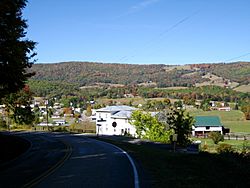
The view down into Monterey
|
|

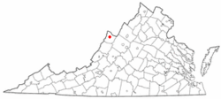
Location of Monterey, Virginia
|
|
| Country | United States |
| State | Virginia |
| County | Highland |
| Area | |
| • Total | 0.32 sq mi (0.82 km2) |
| • Land | 0.32 sq mi (0.82 km2) |
| • Water | 0.00 sq mi (0.00 km2) |
| Elevation | 2,894 ft (882 m) |
| Population
(2020)
|
|
| • Total | 165 |
| • Density | 523.8/sq mi (202.2/km2) |
| Time zone | UTC−5 (Eastern (EST)) |
| • Summer (DST) | UTC−4 (EDT) |
| ZIP code |
24465
|
| Area code(s) | 540 |
| FIPS code | 51-52680 |
| GNIS feature ID | 1498517 |
| Website | https://www.townofmonterey.com/ |
Monterey is a small town located in Highland County, Virginia, in the United States. It is the main town, also known as the county seat, for Highland County. In 2020, about 165 people lived there.
Contents
History of Monterey
The town of Monterey became the main town for Highland County in 1847. This happened around the time a new road, the Staunton and Parkersburg Turnpike, was being built in 1838.
The town got its name from a famous battle called the Battle of Monterrey in Mexico. This battle took place from September 21 to 24, 1846, during the Mexican–American War. In this battle, General Zachary Taylor, who later became a U.S. President, won an important victory for the United States. The word Monterey is Spanish and means "mountain of the king."
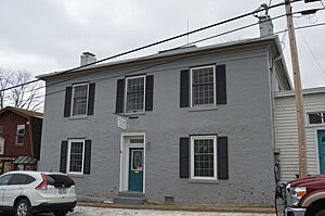
Two important places in Monterey, Monterey High School and the Monterey Hotel, are listed on the National Register of Historic Places. This means they are recognized as special historical sites.
Geography of the Town
Monterey is located at these coordinates: 38°24′43″N 79°34′50″W / 38.41194°N 79.58056°W. This helps pinpoint its exact spot on a map.
The United States Census Bureau says that Monterey covers a total area of 0.3 square miles (0.8 square kilometers). All of this area is land, meaning there are no large lakes or rivers within the town limits.
Transportation in Monterey
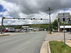
The main roads that go through Monterey are U.S. Route 220 and U.S. Route 250.
- U.S. Route 220 runs from the northeast to the southwest. If you travel southwest, the closest big city you'll reach is Roanoke. If you go northeast, you'll get to Cumberland.
- U.S. Route 250 goes from the northwest to the southeast. Traveling southeast will take you to Staunton, while going northwest leads to Elkins.
US 250 was built through this area in the 1840s. It was part of an old road called the Staunton-Parkersburg Turnpike. This turnpike connected the upper Shenandoah Valley with the Ohio River.
Economy and Tourism
Monterey's economy relies a lot on farming. It also depends on special tourism, which comes from the many events and shops that attract visitors.
The biggest event is the Highland County Maple Festival. This festival happens on the second and third weekends of March. It brings about 50,000 visitors to the area, who come to enjoy maple syrup and other local products.
Population and People
| Historical population | |||
|---|---|---|---|
| Census | Pop. | %± | |
| 1880 | 154 | — | |
| 1900 | 246 | — | |
| 1910 | 240 | −2.4% | |
| 1920 | 313 | 30.4% | |
| 1930 | 290 | −7.3% | |
| 1940 | 309 | 6.6% | |
| 1950 | 262 | −15.2% | |
| 1960 | 270 | 3.1% | |
| 1970 | 223 | −17.4% | |
| 1980 | 247 | 10.8% | |
| 1990 | 222 | −10.1% | |
| 2000 | 158 | −28.8% | |
| 2010 | 147 | −7.0% | |
| 2020 | 165 | 12.2% | |
| U.S. Decennial Census | |||
According to the 2010 census, 147 people lived in Monterey. There were 79 households and 46 families. The town had about 490 people per square mile.
Most of the people in Monterey were White (98.6%). A small number were Native American (0.7%) or Black or African American (0.7%). About 0.7% of the population was Hispanic or Latino.
The population was spread out by age:
- 14.3% were under 18 years old.
- 4.7% were between 18 and 24.
- 19.7% were between 25 and 44.
- 33.4% were between 45 and 64.
- 27.9% were 65 years or older.
The average age in Monterey was 51.5 years.
Climate in Monterey
The weather in Monterey has noticeable differences between high and low temperatures. There is also enough rainfall throughout the year. Summers are usually warm, sometimes hot, and winters are quite cold.
Based on the Köppen Climate Classification system, Monterey has a type of climate called a warm summer humid continental climate. This means it has warm, humid summers and cold winters with snow.
| Climate data for Monterey, Virginia (1981–2010) | |||||||||||||
|---|---|---|---|---|---|---|---|---|---|---|---|---|---|
| Month | Jan | Feb | Mar | Apr | May | Jun | Jul | Aug | Sep | Oct | Nov | Dec | Year |
| Mean daily maximum °F (°C) | 38.2 (3.4) |
43.2 (6.2) |
51.5 (10.8) |
61.6 (16.4) |
71.0 (21.7) |
78.0 (25.6) |
81.1 (27.3) |
79.3 (26.3) |
72.9 (22.7) |
63.8 (17.7) |
51.9 (11.1) |
43.4 (6.3) |
61.5 (16.4) |
| Mean daily minimum °F (°C) | 17.8 (−7.9) |
21.9 (−5.6) |
28.1 (−2.2) |
36.7 (2.6) |
46.0 (7.8) |
53.8 (12.1) |
57.8 (14.3) |
55.9 (13.3) |
49.0 (9.4) |
39.9 (4.4) |
30.7 (−0.7) |
23.8 (−4.6) |
38.6 (3.7) |
| Average precipitation inches (mm) | 2.60 (66) |
3.07 (78) |
3.41 (87) |
4.09 (104) |
4.44 (113) |
3.89 (99) |
4.02 (102) |
3.71 (94) |
2.94 (75) |
3.69 (94) |
4.16 (106) |
3.43 (87) |
43.46 (1,104) |
| Average snowfall inches (cm) | 9.4 (24) |
10.5 (27) |
6.9 (18) |
1.4 (3.6) |
0.2 (0.51) |
0 (0) |
0 (0) |
0 (0) |
0 (0) |
0.3 (0.76) |
2.0 (5.1) |
6.3 (16) |
37 (94.97) |
| Source: Western Regional Climate Center | |||||||||||||
See also
 In Spanish: Monterey (Virginia) para niños
 | George Robert Carruthers |
 | Patricia Bath |
 | Jan Ernst Matzeliger |
 | Alexander Miles |


