Montoro facts for kids
Quick facts for kids
Montoro
|
|||
|---|---|---|---|

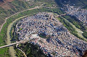
View of Montoro and the Guadalquivir
|
|||
|
|||
| Country | Spain | ||
| Autonomous community | Andalusia | ||
| Province | Córdoba | ||
| Area | |||
| • Total | 586.12 km2 (226.30 sq mi) | ||
| Elevation | 195 m (640 ft) | ||
| Population
(2018)
|
|||
| • Total | 9,436 | ||
| • Density | 16.0991/km2 (41.6965/sq mi) | ||
| Demonym(s) | Montoreños/as | ||
| Time zone | UTC+1 (CET) | ||
| • Summer (DST) | UTC+2 (CEST) | ||
Montoro is a town in Spain. It is a municipality in the province of Córdoba, which is part of Andalusia. The town is built on a special bend of the Guadalquivir river. This river wraps around Montoro from the west, north, and east.
Contents
About Montoro: A Quick Look
Montoro is located about 45 kilometers (28 miles) east-northeast of Córdoba, the capital city of the province. In 2008, about 9,895 people lived there.
This town has a long history! It was once a Roman settlement called Epora. This was a special allied city in the early Roman Republic. Later, during the time of Emperor Augustus, it became a municipium, which was a self-governing town. In the 10th century, it was known as Ḥiṣn Muntur, an Islamic fortress in the region of Córdoba.
Geography: Where Montoro Is Located
Montoro is part of the Alto Guadalquivir region in the province of Córdoba. It is 45 kilometers (28 miles) from the provincial capital. The town is also located in the Guadalquivir valley. Major roads like the Autovía del Sur and the N-420 national highway pass through its area.
The Unique River Bend
The town center sits on a hill where the Guadalquivir River makes a very strong curve. This curve is called an "embedded meander." This special shape of the town comes from its Muslim history in Al-Andalus. Since 2013, this river bend has been recognized as a natural monument. It's also known as Monte Público, meaning a public mountain area.
The river's curve is very deep and cuts into old rocks from about 500 to 250 million years ago. This makes it one of the best examples of an epigenic meander in Spain. This part of the river is important for nature. It is a Special Conservation Area (ZEC Río Guadalquivir-middle section ES6130015). It is also the southern entrance to the Sierras de Cardeña y Montoro natural park. From here, you can see the town of Montoro, which has been a Historic-Artistic Site since 1969.
Montoro's Natural Surroundings
Montoro covers about 581 square kilometers (224 square miles). This area includes mountains to the north and flatlands to the south. A large part of its northern area is a protected natural space. It is part of the Sierra de Cardeña y Montoro natural park and the Southwest Special Conservation Zone (ZEC) of the Sierra de Cardeña y Montoro (ES6130005).
The Guadalquivir River, as it flows through Montoro, is also part of the ZEC Río Guadalquivir-middle section (ES6130015). The river's meander right in the town center is a natural monument called Meandro de Montoro. The Arenoso River, which comes from the mountains, is the most important river flowing into the Guadalquivir in this area.
The land in Montoro varies in height. The highest point is Cerro de Brezorrubios in the mountains, at 782 meters (2,566 feet). The lowest point is 143 meters (469 feet) along the Guadalquivir River. The town itself is on a hill, 195 meters (640 feet) above sea level.
Montoro shares its borders with several other towns. These include Adamuz, Cardeña, Andújar (in Jaén), Marmolejo (Jaén), Pedro Abad, Bujalance, Villa del Río, and Lopera (in Jaén).
Climate: Montoro's Weather
Montoro has a hot summer Mediterranean climate. This means it has very hot and dry summers. The winters are mild and a bit wet. Rain falls moderately throughout the year.
Summers in Montoro are extremely hot. The average highest summer temperature here has been the highest in all of Europe for many years. In July and August, the average highest temperature often goes above 38°C (100°F). Temperatures over 40°C (104°F) happen very often every year.
The coldest temperature ever recorded in Montoro was -7°C (19°F) on February 9, 2012. The hottest temperature was a scorching 47.4°C (117.3°F) on August 14, 2021. This is one of the highest temperatures ever recorded in Spain! In July 2015, the average highest temperature was 41.4°C (106.5°F). For 22 days that month, the temperature was above 40°C (104°F).
| Climate data for Montoro 155 metres (509 ft) asl (2009–2023), extremes (2009-present) | |||||||||||||
|---|---|---|---|---|---|---|---|---|---|---|---|---|---|
| Month | Jan | Feb | Mar | Apr | May | Jun | Jul | Aug | Sep | Oct | Nov | Dec | Year |
| Record high °C (°F) | 25.9 (78.6) |
26.9 (80.4) |
31.3 (88.3) |
37.5 (99.5) |
41.0 (105.8) |
44.6 (112.3) |
47.3 (117.1) |
47.4 (117.3) |
45.7 (114.3) |
38.2 (100.8) |
28.6 (83.5) |
24.1 (75.4) |
47.4 (117.3) |
| Mean daily maximum °C (°F) | 15.1 (59.2) |
17.4 (63.3) |
20.3 (68.5) |
23.7 (74.7) |
29.4 (84.9) |
34.4 (93.9) |
39.0 (102.2) |
38.7 (101.7) |
32.8 (91.0) |
27.6 (81.7) |
19.5 (67.1) |
16.5 (61.7) |
26.2 (79.2) |
| Daily mean °C (°F) | 9.0 (48.2) |
10.5 (50.9) |
13.3 (55.9) |
16.7 (62.1) |
20.9 (69.6) |
25.5 (77.9) |
29.1 (84.4) |
29.0 (84.2) |
24.4 (75.9) |
19.5 (67.1) |
13.0 (55.4) |
10.3 (50.5) |
18.4 (65.2) |
| Mean daily minimum °C (°F) | 2.8 (37.0) |
3.5 (38.3) |
6.3 (43.3) |
9.7 (49.5) |
12.4 (54.3) |
16.6 (61.9) |
19.2 (66.6) |
19.3 (66.7) |
16.0 (60.8) |
11.4 (52.5) |
6.6 (43.9) |
4.0 (39.2) |
10.7 (51.2) |
| Record low °C (°F) | −4.8 (23.4) |
−7.0 (19.4) |
−3.9 (25.0) |
0.9 (33.6) |
3.3 (37.9) |
9.1 (48.4) |
12.5 (54.5) |
12.0 (53.6) |
8.1 (46.6) |
1.4 (34.5) |
−3.9 (25.0) |
−4.6 (23.7) |
−7.0 (19.4) |
| Average precipitation mm (inches) | 54.7 (2.15) |
59.8 (2.35) |
70.5 (2.78) |
60.2 (2.37) |
27.9 (1.10) |
9.8 (0.39) |
0.8 (0.03) |
5.9 (0.23) |
26.6 (1.05) |
47.7 (1.88) |
77.1 (3.04) |
101.9 (4.01) |
542.9 (21.38) |
| Source 1: Agencia Estatal de Meteorología (AEMET OpenData) | |||||||||||||
| Source 2: Agencia Estatal de Meteorología (AEMET 5361X) | |||||||||||||
Twin Towns: Montoro's Friends Around the World
Montoro has special connections with two other towns in different countries. These are called "twin towns" or "sister cities."
See also
 In Spanish: Montoro para niños
 | Isaac Myers |
 | D. Hamilton Jackson |
 | A. Philip Randolph |


