Monument Peak (San Bernardino County) facts for kids
Quick facts for kids Monument Peak |
|
|---|---|
| Highest point | |
| Elevation | 5,272 ft (1607 m) |
| Geography | |
| Location | San Bernardino County, California, U.S. |
| Parent range | San Bernardino Mountains |
| Topo map | USGS San Bernardino North |
| Garcés-Smith Monument | |
|---|---|
| Built | 1776 |
| Designated | September 11, 1956 |
| Reference no. | 618 |
Monument Peak is a special mountain top in the San Bernardino Mountains in California. It stands tall at 5,272 feet (about 1,607 meters) above sea level. This peak is not just a high point; it's also a place with a lot of history, especially about old trails and brave explorers.
Contents
A Crossroads of Old Trails
Monument Peak was once a very important spot for travel. It's where the ancient Mohave Trail crossed over the top of the San Bernardino Mountains. This trail was used by people traveling from the Mojave River area, up through Sawpit Canyon, and then down towards the San Bernardino Valley. It was a key route for many years.
The Mohave Trail: An Ancient Highway
Imagine a time long ago when there were no roads, only paths made by people and animals. The Mohave Trail was one of these paths. It was a centuries-old trade route. It connected Native American tribes living near the Colorado River to those living closer to the Pacific Ocean. People used it to trade goods, share news, and travel between different areas.
Famous Explorers on the Trail
Two very important explorers used the Mohave Trail and are remembered at Monument Peak:
- Father Francisco Garcés: In 1776, Father Garcés became the first known missionary explorer to travel across what is now San Bernardino County. He wrote down his experiences, giving us valuable records of his journey.
- Jedediah Smith: In 1826, Jedediah Smith was the first known Anglo-American to use the Mohave Trail. He was a famous fur trapper and explorer. His journey helped open up new areas for American settlers.
The Garces-Smith Monument
To remember these explorers and the historic trail, a special marker was placed on Monument Peak. This marker is called the Garces-Smith Monument. It sits on Forest Road 2N49, right on the summit.
The first historical marker was put there on September 19, 1931, by the San Bernardino County Historical Society. Later, on September 11, 1956, this site officially became California Historic Landmark number 618. This means it's a protected place because of its importance to California's history.
What the Marker Says
The monument itself has words carved into it that tell its story. It says:
- Traveled by Fr. Francisco Garcés, March, 1776, and Jedediah S. Smith, November, 1826.
- Erected 1931 by San Bernardino County Historical Society. (Marker Number 618.)
The official California Historic Landmark guide also describes the monument:
- NO. 618 GARCÉS-SMITH MONUMENT – This monument marks an old Indian trail, the Mojave Trail, used by Father Garcés in March 1776 on his trip from Needles to San Gabriel. The same trail was used by Jedediah Smith in 1826 on his first trip through San Bernardino Valley.'
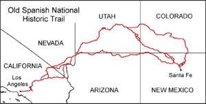
The Old Spanish Trail
A few years after Garcés and Smith, another important trade route opened up. In 1829–1830, a merchant from Santa Fe, New Mexico named Antonio Armijo led a group of 60 men and 100 mules to California. This journey helped create the famous Old Spanish Trail.
While Armijo's route followed much of the path explored by Garcés and Smith, he did not cross over Monument Peak. Instead, he used a route through Cajon Pass. This path was already known to local cowboys, called vaqueros, from the nearby San Bernardino de Sena Estancia. They even helped Armijo's group with food!
 | William M. Jackson |
 | Juan E. Gilbert |
 | Neil deGrasse Tyson |


