Mohave Trail facts for kids
The Mohave Trail was an old trade route used by Native American people. It connected villages of the Mohave Indians along the Colorado River to towns and settlements in coastal Southern California.
Contents
History of the Trail
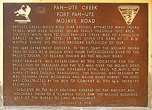
The Mohave Trail began at Mohave villages located along the Colorado River in the upper Mohave Valley. From there, it stretched westward across the dry Mojave Desert. The trail connected important water sources like Piute Spring, Indian Well, Rock Springs, Marl Spring, and Soda Spring. These springs were vital for travelers.
After Soda Spring, the trail led to the start of the Mojave River, southwest of Soda Lake. It then followed the river upstream. Along the river, travelers could find oases with water and plants where the river came to the surface.
Near what is now Summit Valley, the trail turned upwards. It climbed into and over the San Bernardino Mountains at Monument Peak. Finally, it went down into the San Bernardino Valley near the entrance of Cajon Canyon.
Europeans and Americans Use the Trail
In 1776, a Franciscan missionary named Francisco Garcés was the first European to travel and write about this route. Later, the Mohave Trail was used by raiders. These raiders would attack and steal animals from the Spanish missions and ranches in California. Spanish, and later Mexican, soldiers would chase these raiders along the trail.
The Mohave Trail was also used by the first Americans to reach Alta California by land. This happened in November 1826, when an expedition of fur trappers led by Jedediah Smith traveled the route. From 1829 to 1848, merchants from New Mexico and America used much of the trail. It became a key part of the Old Spanish Trail for trading goods.
Wagon Roads and Gold Rush
Between 1847 and 1848, Mormons from Salt Lake City and Los Angeles created a wagon road. This road connected Mormon settlements near Salt Lake City, Utah, to Los Angeles in Southern California. This new route joined the Old Spanish Trail from Utah. It met the old Mohave Trail at a place called Fork of the Road on the Mojave River.
The Mormon Road then followed the Mohave Trail along the river upstream. It left the old trail at its Last Crossing. From there, it crossed 17 miles of desert to Cajon Pass. After 1849, the Mormon Road became a very busy winter route to California. Many Forty-niners used it to avoid dangerous winter conditions.
In 1857, parts of the old trail became part of Beale's Wagon Road. This road linked Fort Tejon to Beale's Crossing on the Colorado River. In 1858, during the Mohave War, the old native path was turned into the Mojave Road. This was a wagon road built to supply the new Fort Mohave from Los Angeles.
During the Colorado River Gold Rush starting in 1862, the Mojave Road became a major route. It led to gold and silver mining areas on the upper Colorado River. In 1864, it connected to the Hardyville - Prescott Road, which led to mining regions in northern and central Arizona.
The Mohave Trail Today
Today, the eastern part of the Mohave Trail, from Manix Wash east to the Colorado River, is mostly followed by a jeep trail. This trail is now known as the Mojave Road.
See also
 In Spanish: Sendero de Mojave para niños
 | William Lucy |
 | Charles Hayes |
 | Cleveland Robinson |


