
Mojave Road facts for kids
Quick facts for kids Mojave Road |
|
|---|---|

Vehicles traveling the Mojave Road stop for a break at Marl Springs
|
|
| Location | Colorado River to Wilmington, Los Angeles, the end marker. |
| Built | Prehistory |
| Architect | Mohave Indians |
| Architectural style(s) | Dirt Trail/Road – Route 66 |
| Designated | 19 March 1985 |
| Reference no. | 963 |
| Designated | 27 September 2021 |
| Reference no. | 100007003 |
| Lua error in Module:Location_map at line 420: attempt to index field 'wikibase' (a nil value). | |
The Mojave Road, also called Old Government Road, is a very old path and a dirt road today. It crosses the Mojave National Preserve in the Mojave Desert in the United States. This rough road is about 147 miles (237 km) long. It starts at the Colorado River and goes to the Mojave River.
You need a four-wheel drive vehicle to travel most of this road. It is not kept up or maintained. Part of the old road is blocked by private land. This is near the old Camp Cady. The road starts again from the north in Manix Wash. If conditions are good, you can drive the whole 133 miles (214 km) in 2 to 3 days.
Contents
History of the Mojave Road
The Mohave Trail: An Ancient Path
Long ago, Native Americans living in the desert used the Mohave Trail. This trail connected watering holes across the Mojave Desert. It went from the Colorado River to the Mojave River. Then it followed the Mojave River to the Cajon Pass. This pass is a gap between the San Bernardino Mountains and San Gabriel Mountains. The trail ended in Southern California at Drum Barracks. Watering holes were about 60 to 70 miles (97 to 113 km) apart.
Francisco Garcés, a Spanish Franciscan missionary, traveled this trail in 1776. He had Mohave guides. Another Franciscan, José María de Zalvidea, also crossed the trail in 1806. He reportedly met five Mohave people near Hesperia. In 1826, Jedediah Smith led the first US citizens to travel the Mohave Trail.
The Old Spanish Trail and Its Connection
From 1829 to 1830, Mexican traders from New Mexico created new routes. These routes became known as the Old Spanish Trail. The first route, called Armijo's route, met the Mohave's trail near Soda Lake.
Later, the Mohave's trail became part of the main Old Spanish Trail. It connected from the north about 12 miles (19 km) west of the Colorado River. It followed the Mohave's trail along the Mojave River. Instead of crossing the mountains into the San Bernardino Valley, they used a new route. This new route went through Cajon Pass. This spot was later called "Fork of the Road". Here, the Old Spanish Trail split from what became the Mojave Road.
The Mojave Road: A Wagon Route

The United States took this land from Mexico in 1848. In 1858, the Mohave Trail became the Mojave Road. It was a wagon road. It connected to the new Beale's Wagon Road. This road went across northern New Mexico Territory. It started at Fort Defiance and ended at Beale's Crossing on the Colorado River. There, it joined the Mojave Road.
Settlers coming west used Beale's Wagon Road and the Mojave Road. This route was shorter and cooler than other paths. It also had better food for animals and more water. Soon, fighting started between the Mohaves and the settlers. This led to the Mohave War.
After the Mohave War, the US government took charge of the Mojave Road. Army posts were set up to protect travelers. Fort Mojave was built in 1859. Camp Cady was built in 1860. Smaller outposts were added later. The army protected settlers from attacks by Paiute, Mojave, and Chemehuevi Native Americans until 1871. This protection helped mining and farming grow in the area.
Exploring the Mojave Road Today
The eastern end of the Mojave Road starts near the Colorado River. This is close to Beale's Crossing, north of Needles. The western end is near the Rasor Off-Highway Vehicle Area and Afton Canyon Natural Area. It ends near the Manix Wash.
Important Places Along the Way
Here are some important spots you will find along the Mojave Road, going from east to west:
- The Colorado River – This is where the trail begins. It is near Beale's Crossing, across from where Fort Mohave was built. (mile 0) 35°02′47″N 114°37′40″W / 35.046280°N 114.627890°W
- Beaver Lake – This was once a lake or a slough of the Colorado River. The original road went north of the lake. A battle of the Mohave War happened here. Today, the lake has dried up. The modern trail crosses where the lake used to be. 35°04′12″N 114°38′24″W / 35.070010°N 114.639990°W
- Piute Creek – This creek gets its water from Piute Spring. It is a desert oasis with trees and plants. (mile 23) 35°06′54″N 114°59′07″W / 35.115020°N 114.985260°W
- Fort Piute – This fort was built in 1867 by the US army. It helped guard the road between Fort Mohave and San Bernardino. It is next to Piute Creek. (mile 23) 35°06′54″N 114°59′07″W / 35.115020°N 114.985260°W
- Lanfair Valley – Cattle ranches have been in this valley since 1880. (mile 34) 35°05′41″N 115°01′10″W / 35.094780°N 115.019520°W
- Indian Hill and Indian Well – Indian Hill is a summit about a mile north of the Mojave Road. Indian Well is an old well nearby. (mile 40) 35°08′37″N 115°09′15″W / 35.143530°N 115.154260°W 35°08′43″N 115°09′32″W / 35.145278°N 115.158889°W
- Joshua Tree Forest – The road becomes very narrow as it goes through this thick forest. (mile 47) 35°08′36″N 115°17′29″W / 35.143340°N 115.291460°W
- Rock Spring – This is the largest watering hole on the Mojave Road. Water flows down large rocks here. There is also an old cabin. (mile 49) 35°09′10″N 115°19′38″W / 35.152830°N 115.327300°W
- Government Holes – Another water source in Round Valley. It has an old concrete trough. (mile 52) 35°08′51″N 115°21′33″W / 35.147490°N 115.359200°W
- Cedar Canyon – This is the highest point of the trip. You will reach about 5,000 feet (1,500 m) elevation here. (mile 56) 35°09′10″N 115°21′43″W / 35.152900°N 115.362000°W
- Kelso-Cima Road – This is a paved road you will cross. It is in the middle of your trip. (mile 62) 35°10′34″N 115°30′32″W / 35.176210°N 115.509010°W
- Marl Spring – Another spring with a simple concrete trough. (mile 70) 35°10′15″N 115°38′51″W / 35.170700°N 115.647590°W
- Mojave Road Mail Box – You can sign your name at this flagpole. (mile 74) 35°11′07″N 115°41′34″W / 35.185400°N 115.692840°W
- Willow Wash – A sandy wash that runs near the Cima Volcanic Range. (mile 77) 35°09′46″N 115°50′32″W / 35.162850°N 115.842090°W
- Kelbaker Road – This is a paved road between Baker and Kelso Junction. 35°13′21″N 115°52′44″W / 35.2226°N 115.8789°W
- Seventeen Mile Point – A mountain that marks the halfway point between Soda Spring and Marl Spring. 35°13′18″N 115°53′35″W / 35.22165°N 115.89296°W
- Soda Lake – A large dry lake. Be careful when crossing, especially in winter. (mile 97) 35°09′09″N 116°03′10″W / 35.152410°N 116.052710°W
- Soda Springs in (Zzyzx) – A small private building at the edge of Soda Lake. 35°08′34″N 116°06′17″W / 35.142790°N 116.104740°W
- Travelers Monument – Also called Government Monument. Travelers carry a rock across the dry lake and add it to this pile. (mile 100) 35°07′51″N 116°05′43″W / 35.130840°N 116.095270°W
- Rasor OHV Area – An area where you can drive off-road vehicles. (mile 103) 35°06′32″N 116°08′37″W / 35.108780°N 116.143630°W
- Sand Dunes – You can find some soft sand dunes here. (mile 106) 35°04′50″N 116°11′38″W / 35.080507°N 116.193786°W
- Afton Canyon – A deep canyon with steep walls. It has a special riparian habitat (plants and animals near water). (mile 116) 35°02′34″N 116°18′34″W / 35.042720°N 116.309500°W
- Mojave River crossing – This is the only place on the trail where you cross water. (mile 121) 35°02′16″N 116°22′52″W / 35.037740°N 116.381120°W
- Manix Wash – This is where the Mojave Road officially ends. (mile 133) 34°58′28″N 116°32′27″W / 34.974380°N 116.540800°W
- Camp Cady – This was a former U.S. Army camp. It was located along the old Mojave Road on the Mojave River. (mile 136.1) 34°56′46″N 116°35′22″W / 34.946111°N 116.589444°W
- Fork of the Road – This is a spot on the north bank of the Mojave River. Here, the old Mojave Road split from the Old Spanish Trail or Mormon Road. (mile 147) 34°54′05″N 116°45′35″W / 34.901389°N 116.759722°W
- Drum Barracks – This is the very end of the trail in the west. It is in Wilmington, Los Angeles. 33°47′05″N 118°15′29″W / 33.78466°N 118.258163°W
Special Recognitions
The Mojave Road in Los Angeles became a California Historic Landmark (No. 963) on March 19, 1985. It was also added to the National Register of Historic Places in 2021.
The California Historic Marker says:
- NO. 963 THE MOJAVE ROAD – Long ago, Mohave Indians used many paths to cross the Mojave Desert. In 1826, Jedediah Smith, an American trapper, used their paths. He was the first non-Indian to reach the California coast by land from the middle of America. These paths were made into a military wagon road in 1859. This "Mojave Road" was a main link between Los Angeles and places to the east. It was used until a railway crossed the desert in 1885.
Camp Cady also has a California Historical Landmark Marker (No. 963-1). It says:
- NO. 963-1 Camp Cady was on the Mojave Road. This road connected Los Angeles to Albuquerque. Travel on this road and the nearby Salt Lake Road was difficult. Paiutes, Mohaves, and Chemehuevis defended their land. To protect both roads, Camp Cady was built by U.S. Dragoons in 1860. The main building was a strong mud fort. Better camp buildings were built 1/2-mile west in 1868. After peace was made, the army left in 1871. The protection from Camp Cady helped travelers, goods, and mail. This boosted California's economy and growth.
Images for kids
-
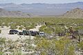
Vehicles traveling the Mojave Road stop for a break at Marl Springs
-
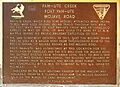
This plaque tells about the Mojave Road's history.
See also
 In Spanish: Sendero de Mojave para niños
