Morisset, New South Wales facts for kids
Quick facts for kids MorissetGreater Newcastle, New South Wales |
|||||||||||||||
|---|---|---|---|---|---|---|---|---|---|---|---|---|---|---|---|
| Population |
|
||||||||||||||
| • Density | 150.48/km2 (389.7/sq mi) | ||||||||||||||
| Established | 1887 | ||||||||||||||
| Postcode(s) | 2264 | ||||||||||||||
| Elevation | 35 m (115 ft) | ||||||||||||||
| Area | 27.1 km2 (10.5 sq mi) | ||||||||||||||
| Location |
|
||||||||||||||
| LGA(s) | City of Lake Macquarie | ||||||||||||||
| Region | Hunter | ||||||||||||||
| Parish | Morisset | ||||||||||||||
| State electorate(s) | Lake Macquarie | ||||||||||||||
| Federal Division(s) | Hunter | ||||||||||||||
|
|||||||||||||||
Morisset is a town in the Hunter Region of New South Wales, Australia. It is part of the Greater Newcastle area. Morisset is located west of Lake Macquarie, close to the M1 Pacific Motorway. It sits about halfway between Gosford and Newcastle. In 2021, about 4,078 people lived in the main suburb of Morisset. The wider Morisset area, including Cooranbong, had an estimated population of 27,828 people in 2021.
Contents
History of Morisset
The town of Morisset is named after Major James Thomas Morisset. He camped here in 1823 while traveling overland from Sydney to Newcastle. Later, Major Morisset was in charge of the Norfolk Island prison from 1829 to 1833. There was some confusion about how to spell the town's name in the past. People used different spellings like Morissett or Morriset.
Some people thought the town was named after Edric Norfolk Vaux Morisset. He was James Morisset's son. However, a letter written in 1914 by James Morisset's grandson said this was not true.
The first settlement in this area was at Cooranbong in 1826. This was about 5 kilometres (3 miles) west of where Morisset is now. Early settlers tried different types of farming. Soon, cutting down trees for wood became a very important industry. Most goods were transported by river boat on Dora Creek. This made Cooranbong the easiest place to reach.
The town of Morisset itself did not really exist until 1887. This was when the Sydney-Newcastle railway was built. Morisset grew up around the train station as a town for sawmills. The town was officially declared on December 3, 1887.
In 1908, a specialized hospital opened on a large property near the lake. In the 1960s, this hospital had many patients, around 1,600. Today, it is known as Morisset Hospital and has about 130 beds. The first bus service in the area was started by the Ward family.
More recently, the Morisset Peninsula, east of the town, has become a main living area. It has grown a lot since the Eraring Power Station was built in 1986. Many retirement villages have also been built there. While some larger land blocks have been divided, much of the Morisset area is still bushland, National Park, and Aboriginal reserves.
Heritage Sites
Morisset has some places that are important for their history. These are called heritage-listed sites.
- Morisset Park Road: Morisset Hospital
Education in Morisset
Morisset has several schools for students.
- Morisset Public School is a state primary school. It opened in 1891. For a while, it also had high school classes.
- Morisset High School is a state high school. It opened in 1965. The high school classes moved here from the public school.
- St John Vianney School is a Catholic primary school. It opened on January 17, 1962. It is now part of the Roman Catholic Diocese of Maitland-Newcastle.
Transport Links
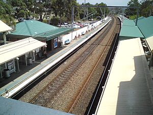
The Morisset railway station is on Dora Street. You can catch NSW TrainLink trains here to Sydney and Newcastle. These trains run on the Central Coast & Newcastle Line. There are also longer-distance trains that go to Maitland and other towns further north.
The train station is also a hub for local bus services.
- Bus routes 278 and 279 serve the towns on the Morisset Peninsula.
- Bus route 280 goes to Cooranbong.
These bus services are run by Hunter Valley Buses. In 2009, Rover Coaches started a new weekday bus service, Route 163. This route connects Morisset to Cessnock and Kurri Kurri.
Things to Do in Morisset
Morisset is located near the eastern shores of Lake Macquarie. It is also close to the Watagans National Park and the Watagan Mountains. The town centre has many shops, cafes, and restaurants. Morisset is a great starting point to explore the trails and paths around the Lake Macquarie region.
The Dillwynia Bushland Reserve is just south of the Morisset railway station. This land is looked after by members of the Biraban Local Aboriginal Land Council.
Media
You can listen to Christian radio on 87.8 FM in Morisset. This station broadcasts the 3ABN Australia Radio Network. The 3ABN Australia Production Centre is also located in Morisset.
 | DeHart Hubbard |
 | Wilma Rudolph |
 | Jesse Owens |
 | Jackie Joyner-Kersee |
 | Major Taylor |


