Morrisville, New York facts for kids
Quick facts for kids
Morrisville, New York
|
|
|---|---|
|
Village
|
|

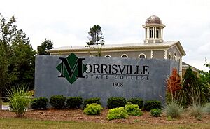
Sign for Morrisville State College in the village
|
|
| Country | United States |
| State | New York |
| County | Madison |
| Area | |
| • Total | 1.02 sq mi (2.65 km2) |
| • Land | 1.02 sq mi (2.65 km2) |
| • Water | 0.00 sq mi (0.00 km2) |
| Elevation | 1,348 ft (411 m) |
| Population
(2020)
|
|
| • Total | 1,633 |
| • Density | 1,594.73/sq mi (615.61/km2) |
| Time zone | UTC-5 (Eastern (EST)) |
| • Summer (DST) | UTC-4 (EDT) |
| ZIP code |
13408
|
| Area code(s) | 315 |
| FIPS code | 36-48593 |
| GNIS feature ID | 0957706 |
| Website | https://www.morrisvilleny.com/ |
Morrisville is a small village located in Madison County, New York, United States. In 2020, about 1,633 people lived here. The village got its name from its founder, Thomas Morris.
Morrisville is in the northwest part of the Town of Eaton. It is located along US Route 20. The village's zip code is 13408. A college, Morrisville State College, is also found in the village.
Contents
History of Morrisville
The area was first named "Morris Flats" after Thomas Morris. In 1817, Morrisville became the main town, or "county seat," for Madison County. This meant important government offices were located there. Before that, the county seat was in Cazenovia.
However, in 1907, the county seat moved again to Wampsville. This left the old county buildings empty.
A year later, in 1908, the New York State School of Agriculture was started. This new school took over the empty county buildings. Today, this school is known as Morrisville State College.
Some important buildings in Morrisville are listed on the National Register of Historic Places. These include the First National Bank of Morrisville, the Morrisville Public Library, and the Old Madison County Courthouse. These places are recognized for their historical importance.
Geography and Climate
Morrisville is located at coordinates 42°53′55″N 75°38′52″W / 42.89861°N 75.64778°W. This helps pinpoint its exact spot on a map.
The United States Census Bureau says that the village covers about 1.1 square miles (2.65 square kilometers) of land. There is no water area within the village limits.
Weather in Morrisville
Morrisville experiences a climate with warm summers and cold, snowy winters. Temperatures can vary a lot throughout the year. July is usually the warmest month, while January is the coldest. The area gets a good amount of rain and snow each year.
Population and People
The population of Morrisville has changed over the years. Here's how it has grown and shrunk:
| Historical population | |||
|---|---|---|---|
| Census | Pop. | %± | |
| 1870 | 570 | — | |
| 1880 | 741 | 30.0% | |
| 1890 | 726 | −2.0% | |
| 1900 | 624 | −14.0% | |
| 1910 | 500 | −19.9% | |
| 1920 | 497 | −0.6% | |
| 1930 | 583 | 17.3% | |
| 1940 | 666 | 14.2% | |
| 1950 | 1,250 | 87.7% | |
| 1960 | 1,304 | 4.3% | |
| 1970 | 2,296 | 76.1% | |
| 1980 | 2,707 | 17.9% | |
| 1990 | 2,732 | 0.9% | |
| 2000 | 2,148 | −21.4% | |
| 2010 | 2,199 | 2.4% | |
| 2020 | 1,633 | −25.7% | |
| U.S. Decennial Census | |||
In 2000, there were 2,148 people living in Morrisville. Most people were White, but there were also African American, Native American, and Asian residents. About 4% of the population was Hispanic or Latino.
The village had 362 households. About 27% of these households had children under 18 living with them. The average age of people in Morrisville was 20 years old, which is quite young. This is likely because of the college located there.
The average income for a household in the village was $34,375. About 19.7% of the total population lived below the poverty line. This included 27.2% of children under 18.
Education in Morrisville
Morrisville is an important place for education. It is home to SUNY Morrisville, which is a part of the State University of New York system. This college has special facilities like the Morrisville fish hatchery and the Morrisville Equestrian Center.
There are also other colleges nearby. Colgate University is about eight miles to the southeast. Cazenovia College is 12 miles to the west. And Syracuse University is about 30 miles northwest of Morrisville.
See also
 In Spanish: Morrisville (Nueva York) para niños
 | William M. Jackson |
 | Juan E. Gilbert |
 | Neil deGrasse Tyson |


