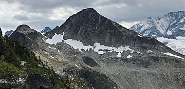
Mount Afton facts for kids
Quick facts for kids Mount Afton |
|
|---|---|

Mount Afton, north aspect
|
|
| Highest point | |
| Elevation | 2,553 m (8,376 ft) |
| Prominence | 171 m (561 ft) |
| Parent peak | Mount Jupiter (2786 m) |
| Listing | Mountains of British Columbia |
| Geography | |
| Location | Glacier National Park British Columbia, Canada |
| Parent range | Selkirk Mountains |
| Topo map | NTS 82N/4 |
| Climbing | |
| First ascent | 1893 H. Lambert, Miss MacLeod, H. Perley, W. Rau, W. Stables |
| Easiest route | YDS 2-4 Scrambling |
Mount Afton is a tall mountain peak found in Glacier National Park. This park is in the Selkirk Mountains of British Columbia, Canada. Mount Afton stands about 2,553 meters (8,376 feet) high.
It is located near the northern part of Asulkan Ridge. The mountain is about 8 kilometers (5 miles) south of Rogers Pass. It is also about 56 kilometers (35 miles) northeast of Revelstoke. And it's about 40 kilometers (25 miles) west of Golden.
First Climbers of Mount Afton
The very first time someone successfully climbed Mount Afton was in 1893. A group of five people made this amazing journey. They were Herbert Lambert, Miss MacLeod, Harold A. Perley, William H. Rau, and William Stables. They climbed the mountain using its east buttress, which is a strong, projecting part of the mountain.
How Mount Afton Got Its Name
The mountain was climbed again in 1895 by three more explorers. These climbers were Philip Stanley Abbot, Charles Ernest Fay, and Charles S. Thompson. They decided to name the mountain after themselves. They took parts of their last names to create "Afton." The "A" came from Abbot, "F" from Fay, and "T" and "ON" from Thompson.
The name "Mount Afton" was officially accepted on March 31, 1924. This was approved by the Geographical Names Board of Canada.
Climate Around Mount Afton
Mount Afton is in a place with a subarctic climate. This means it has very cold and snowy winters. The summers are usually mild, not too hot. Temperatures can drop below -20 °C (-4 °F). With the wind, it can feel even colder, sometimes below -30 °C (-22 °F).
The snow and rain that fall on the mountain eventually flow north. This water drains into the Illecillewaet River.
 | Claudette Colvin |
 | Myrlie Evers-Williams |
 | Alberta Odell Jones |


